In the last few years, climate change has made its impact known in violent, eye-grabbing ways. Heat waves and drought slowly roll across the planet; hurricanes and floods and wildfires bring sudden devastation to communities that were once safe. But there are also slower, more insidious impacts that we can easily forget about in the wake of those disasters, including the most classic impact of them all: sea-level rise.
The East Coast is particularly vulnerable to rising seas, and in her new book Charleston: Race, Water, and the Coming Storm (Pegasus Books, April 4, 2023), Susan Crawford, a writer and professor at Harvard Law School, explores how the historic city, the largest in South Carolina, is preparing — or failing to prepare — for what’s to come. Flooding has become increasingly commonplace in Charleston, Crawford writes, and the city’s racial history has meant that low-income communities of color are bearing the worst of the impact, with little hope for relief.
Charleston is a bellwether for what the rest of the East Coast can expect as the waters of the Atlantic creep ever higher. When we spoke, Crawford, author of the books Fiber and The Responsive City, among others, began by describing her book as a survival story rather than a climate story. Our conversation has been edited for length and clarity.
Let’s start with what you just told me, which is that it’s not a climate story, it’s a survival story. What do you mean by that?
Things are pigeonholed as climate inappropriately. This is more about the question of: Can we overcome our polarization and limitations as human beings and plan ahead for a rapidly accelerating cataclysm that will, in particular, hit the East Coast at three or four times the rate of speed it goes the rest of the world? Can we plan ahead? Can we think about what anybody with a belly button needs to thrive? Because after all, isn’t that the role of government?
What made you decide to write a book about Charleston?
I came to Charleston initially on a solo vacation in December 2017. I went there for Christmas. And it’s an interesting place, but I didn’t really know what the history of it was. And I decided to go back in February 2018 to interview the man who’d recently stepped down as mayor, Joe Riley. He had been mayor for 40 years. His tagline was America’s favorite mayor. And he had transformed Charleston over his tenure into a tourist magnet, seven million tourists a year. Lots of development. It became a food and arts destination. And I was just curious about Mayor Riley. So I contacted a local journalist named Jack Hitt, and he suggested that I ask the mayor about the water.
So, when I interviewed Riley, I asked him about flooding. And he’s a very charming guy, little bowtie, little khaki suit. And he clammed up. All he said was that it was going to be very expensive. That was it.
And I said, “huh, maybe there’s a story here.” And this became a quest to try to figure out what the Charleston story was. At first, I thought it was going to be a story of local government heroism. And in a sense, it still is. I think the city is, in a sense, doing what it can. But then I was lucky enough to be introduced to several Black resident leaders at Charleston who were very generous to me and explained what it’s like to be Black in Charleston, and the ongoing lack of a Black professional class in Charleston. There’s sort of the idea that the civil war never ended in Charleston: There’s a lack of Black advisors near the mayor, although there are Black members of city council.
Charleston’s successes and failures are just harbingers of what we will be seeing up and down the East Coast. They’re more visible in Charleston, and Charleston lives in the dreams of millions of people who want to visit. The failures of the structures around Charleston and inside Charleston are fractal in nature. They are replicated across the globe. It’s Confederate Disneyland, and it’s about to be SeaWorld.
 Courtesy of Pegasus Books
You said Charleston is going from Civil War Disneyland to SeaWorld. How so?
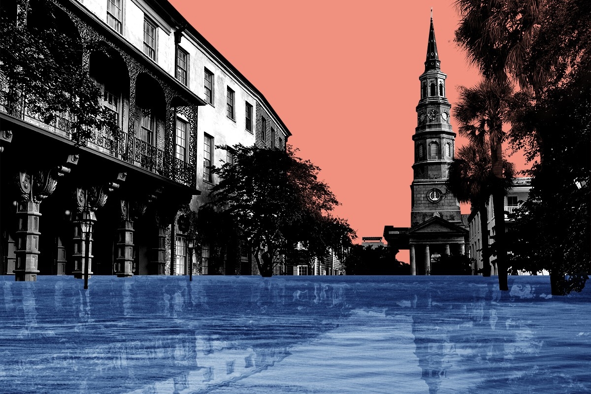
Charleston is extremely low in terms of its topography. The peninsula itself was built on fill, like much of Boston. Enslaved people filled in the perimeter of what is now today’s peninsula. So about a third of that peninsula — the lower part where these gorgeous historical houses are — is five feet or less above sea level. And then these outlying suburbs, many of which were annexed into Charleston’s property tax base by Mayor Riley over the course of his mayoralty, were historically marshy wetlands. There’s very little high land in the entire city of Charleston. A lot of the area outside off the peninsula is about 10 feet or less above sea level. So Charleston’s topography sets it up for the threat of rising waters.
It’s actually more exposed than the Netherlands, because it’s not as if there are defined waterways that lead inland — it’s actually a gazillion interconnected tiny watersheds across a flat area. So water can just roll over the place unimpeded when it rises.
Charlestonians have almost gotten used to ongoing flooding, there’s a sort of complacency that sets in. And there’s also, I think, a sense in Charleston, that they’ve missed a lot of big storms recently, and maybe they believe it’s not going to happen to them. But they’re just one storm away from being flattened, basically.
Right now the city has a single planning horizon in mind, which is 2050, and a single level of sea level rise, which is 18 inches. That might be fine up until 2050. But after that we’re going to see very rapidly accelerating sea level rise — scientists are predicting more like three feet by 2070. And then at least five by the end of the century.
Get the best of Heatmap delivered to your inbox:
And how does the history of Charleston play into that?
Charleston was the place where 40% of the enslaved people forcibly brought to America first step foot. It’s the place where, after the slave trade was outlawed in 1808, a great deal of the domestic slave trade was carried out. Its entire economy, initially, was based on extractive labor from enslaved people.
After the Civil War, a lot of free Black people moved onto the peninsula seeking work. Charleston in the 1970s was a majority Black peninsula, with 75% Black residents. Today, it’s at most 12 percent on the peninsula: That whole population has been displaced and moved to North Charleston, which has one of the highest eviction rates in the country, or off in far flung suburban areas where it’s cheaper. There are still some concentrated areas of Black residents on the peninsula on the east side, which floods all the time and has been a lower income area for all of Charleston’s history. And then there are public housing areas, mostly inhabited by Black residents.
You mention early in the book that the city’s drainage system might not work in the future.
Well, for a long time, Charleston, simply lived with flooding and let its sewage go right into the water. But in the late 19th century, a brilliant and energetic engineer figured out how to install tunnels underneath the streets of the peninsula that would drain sewage away from the houses and also take water out of the streets. It’s a gravity driven tunnel system, and a lot of that system is still in place.
But gravity isn’t going to help as the seas rise. The peninsula will be at the same level as the sea, so the gravity-based system won’t function. The city’s hard working stormwater manager is working on upgrading that system substantially, furnishing them with pumps, so they don’t have to rely just on gravity. But they’re going to need a lot of pumping to get the water off the streets in order to make life possible on the peninsula.
Mayor Riley, to his credit, developed a stormwater plan in 1984. But it was all very expensive, and many of the projects have not yet been completed, in particular on the west side of the peninsula. And all of that planning is premised on the idea that you’re supposed to pump the water off the peninsula, that no matter how much water there is, you’re going to take it away. That kind of money has not been invested in the outlying suburbs. When water comes there it just sits.
The other factor is that the groundwater in Charleston is very close to the surface. So as seas rise, the groundwater is also going to be rising and it will have nowhere to go. You know, they’re doing their best to think of ways to get that water away. But as rainwater gets heavier and seas rise, groundwater rises, and you’ll have a situation of chronic inundation.
 A historical map of Charleston, as seen in the book.
How do local leaders talk about that? You said that Mayor Riley clammed up, and I noticed in your book that the term climate change seems to be sort of taboo.
This is gradually shifting, but at the state level, certainly, you’re better off not talking about the human causes of climate change. There’s no point. Because then you look as if you’re Al Gore, bringing the heavy hand of government everywhere, and that’s not a good look. And the state government makes it impossible for cities to include the idea of retreating in their comprehensive plans.
When I first interviewed current Mayor Tecklenburg about this whole subject, he said, “do you want to talk about climate change or sea level rise?” And at first I was befuddled, but then I understood what he was saying: Let’s not talk about why it’s happening. But we can talk about the fact that it is happening, because we see it every day.
And so that that’s the approach: Don’t talk about the causes, talk about what’s going on. And in fact, that is, for me, the entire approach of this book. I, of course, fully accept that humans are causing the forcing of temperatures to their stratospheric heights these days, and we need to lower emissions and do whatever we can to decarbonize our economy. But I’m concerned that even if we do that, the changes in the climate that are already baked in are going to have disastrous effects on human beings’ lives. So we need to be planning in both directions at once, both planning to reduce missions and planning to help people survive.
This book is centered on all these voices of folks who are seeing this happen firsthand, and are also trying to do something about it. How do they view this issue?
One of the leading characters here is Reverend Joseph Darby, who is a senior AME minister, and also the co chair of the local NAACP branch in Charleston. He’s in his 70s, very wise, and he has, of course, personally experienced flooding, and in particular, flooding that makes his church inaccessible since he’s a preacher on the peninsula.
He told me he learned early in his career that it was important never to be surprised by anything he heard in Charleston. He could be shocked, he could be astonished, but he couldn’t be surprised. He continues to feel that way in the absence of powerful Black voices advising the mayor.
His two boys moved away from Charleston, as much as he might have hoped that they would stay. The Black professional class doesn’t stay in Charleston because it’s just too hard. It’s just not worth it. He feels that there’s a sort of a benevolent paternalism from political leaders, a sense of “we know what’s best for you folks.”
The Black leaders I talked to pointed out that nobody is talking about how we’re going to help low income and Black residents of the region who have nowhere to go when the flooding hits in a big way. Nobody’s talking about the kind of holistic support services that are going to be needed, and this will just further entrench and amplify the inequality and unfairness. They also point out that this is a regional problem and national problem. And they just don’t see that kind of coordination happening.
There’s a chapter in your book about how some federal agencies like the U.S. Army Corps of Engineers have plans for how to save it. What is being talked about there?
Yeah, the big plan in Charleston is to work with the Army Corps of Engineers on building a 12-foot-tall wall around the peninsula with gates in it, that would, in theory, protect the peninsula from storm surges. The wall wouldn’t be designed to protect the 90% of people who don’t live on the peninsula. Nor would it be designed to do anything about the heavy rain or the constant high tides. It’s just for storm surges.
It’s a plan to protect the high property values on the peninsula, and in particular the areas that are good for tourism. You know, pillars of the Charleston economy. It’s fair to say that that if it’s ever built, that wall will be outmoded by the time it’s finished, because it’s built to a very low standard — 18 inches of sea level rise by 2050. The reason it’s built to such a low standard is that if it was any higher the wall would mess with the freeways that come onto the peninsula from the airport. And the Army Corps of Engineers representative was pretty frank about that. He said that just wouldn’t pencil out, that wouldn’t make sense economically to build anything higher.
So I mean, Charleston is stuck, because the only vessel for money right now is coming through these armoring projects being built by the Army Corps. And the plan is for that wall to be built in very slow sections, gradually protecting parts of the peninsula. As planned, it would take 30 years to build. So the underlying plan is for Charleston to be hit by a disaster that then causes enormous concern and empathy for Charleston, and a huge congressional appropriation bill. That’s what happened after Katrina. And then that wall would be finished quickly,
The wall as designed would not protect a couple of Black settlements farther up the peninsula, because the cost benefit analysis doesn’t work out. But it’s not Charleston’s fault that it’s planning on a disaster, because our entire approach to this survival question is premising on disaster recovery, not on proactive planning. There are 30 federal agencies that have all these scattershot programs that are aimed at disaster recovery, and there is very little advanced planning going on.
How did the racial history of Charleston play into those decision making processes? I think it’s not immediately obvious how this history can make itself known through, say, a cost benefit analysis for these kinds of projects.
Well, in our country, we’ve had decades of exclusion through segregation and redlining and soft processes not quite understood by a lot of people that have pushed Black citizens into lower, more rapidly-flooding areas. And that history then plays out into what we decide to value. If our history has put Black Americans into more flood-prone, lower value housing over time, then it’s a garbage-in, garbage-out algorithm. If we then decide to only protect the places that are high property value, we will inevitably, yet again, exclude Black residents from the benefit of federal planning.
So it’s a pattern that was set a long time ago and did not arise by accident, playing out in the way we make decisions today.
And to its credit, the Biden administration just issued a terrific Economic Report of the President that said inequality and property values and ownership in the U.S. reflects decades of exclusion of racial minorities from home ownership and public investment, and we need different criteria to capture the differential vulnerability of these populations. So yeah, they’re on it. They understand.
Does that retroactively apply to projects like the one in Charleston?
No, Congress has already voted on the Charleston project. They say they’ve got this great benefit-cost ratio, one of the best in the nation, they’re really trumpeting it. It feels strange that we would pump billions of dollars into short sighted armoring of coastline that doesn’t protect against the daily harms we know are going to happen.
When do you think people might start talking about managed retreat?
Well, people’s attachment to their homes is very deep. Not just for Black residents who can’t afford to leave, but for white residents and rich people as well. It’s likely it will take a series of disasters separated by very few months to convince everybody that this place really isn’t going to be livable. For decades, we already know that you can show maps to city planners, you can talk about the data to people until you’re blue in the face. This is especially true when it comes to coastal properties. It’s not rational. People are highly reluctant to leave.
It also could be a sudden cliff in property valuation, which is likely to happen in the next few years as there are actors in the financial system who fully understand this. Private flood insurers walked away from selling insurance there, leaving the federal government providing 95% or more of the flood insurance in Charleston. At some point, the fact that coastal real estate is now overvalued in the United States to the tune of $200 billion will be reflected in residential property markets up and down, and people will be unable to sell their houses. And then we might see a change in behavior.
The only country in the world that is actively talking about relocation is the Netherlands. They are planning or at least talking about needing to keep options open to move large populations away from Amsterdam, Rotterdam, towards Germany. But for everybody else, it is extremely difficult to talk about it. And you would hope that we wouldn’t have to have a global economic crisis to force planning, because that’s what this would amount to. It would be worse than 2008 if this overvaluation is suddenly corrected, because the loss of property value is permanent, and it’s not coming back. And it would be too bad if it took that kind of market crash to force planning in this direction.
What would you like to see from the government? Do you think there should be more talk, at the federal level, about moving people away?
If we had a president who was able to engage in long term planning, we could, with dignity and respect, change the financial drivers and levers and incentives to encourage people to understand this risk and move away from it without having to lose all their wealth. And without having to be cast into the role of migrants.
We absolutely can do this. We built the Hoover Dam, and we built the Interstate Highway System. We can afford what we care about. And if this was a priority, we could do this. But for me, the moment of redemption, the first moment of redemption will be when it’s somebody’s job in the White House to speak publicly about this constantly in league with the best scientists in the world.


 Courtesy of Pegasus Books
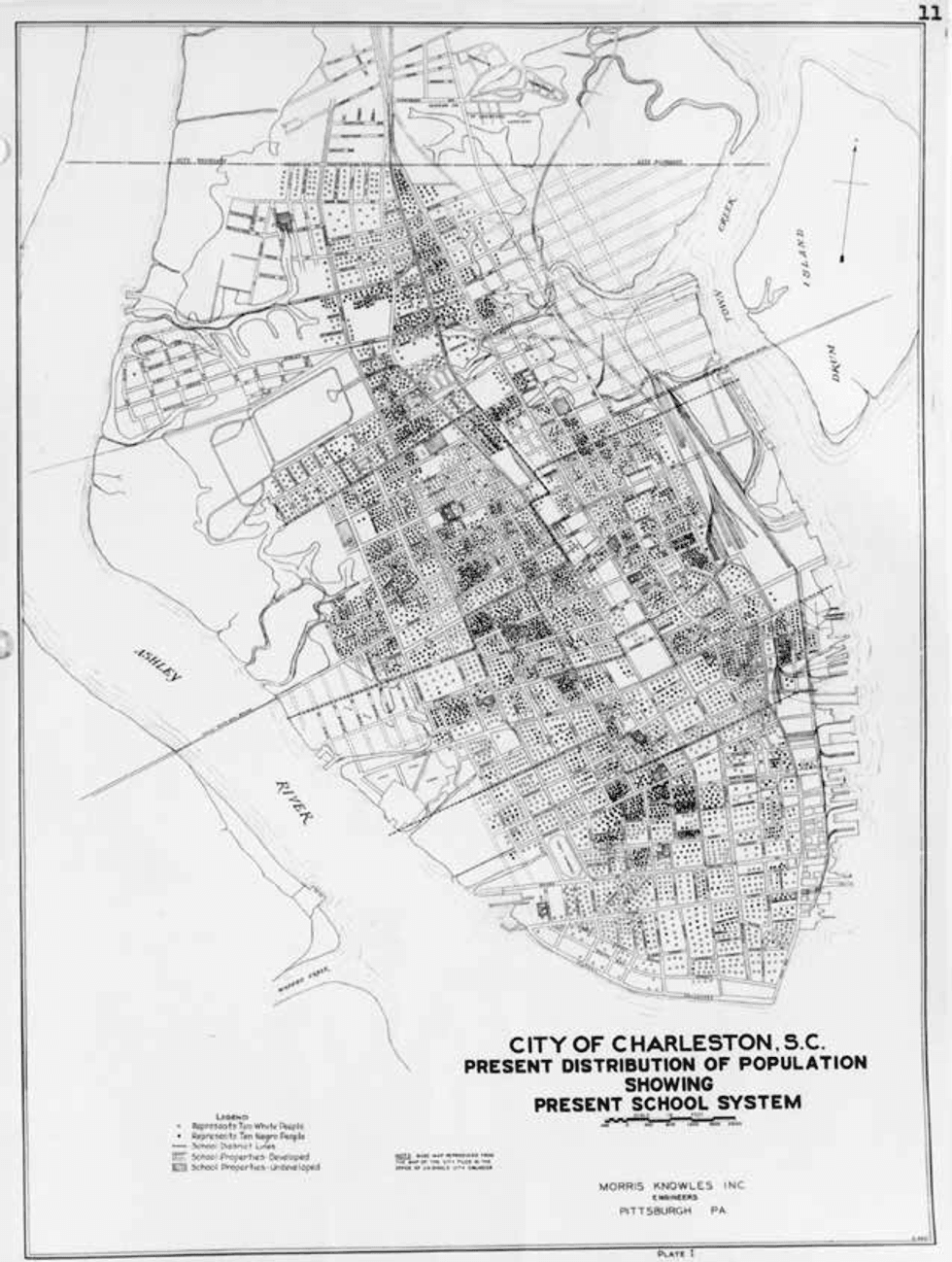 A historical map of Charleston, as seen in the book.


 Chilean President José Antonio Kast. Santiago Mazzarovich / AFP via Getty Images