Those dual-fuel plants pushed over 10 gigawatts of electricity onto the grid on the evening of July 1— about a third of the total load in the state — and hit similar peaks on the 2nd and 3rd. The peaker fleet owned and operated by the New York Power Authority was operational for over two-thirds of the heat wave, which persisted for four consecutive days, while some ran nonstop from 7 a.m. July 2 to 3 a.m. July 4, according to NYPA.
In response to questions about the use of its peakers during the heat wave, a NYPA spokesperson told me, “During times of peak energy demand, like last week’s heat wave, the state’s independent grid operator called upon NYPA’s Small Natural Gas Power Plants to run well beyond their typical usage to meet high energy needs and prevent localized blackouts.”
While specific generator information is a protected trade secret, they said, “capacity suppliers are critical resources to meet system peak loads like those experienced during the recent heatwave.”
And yet still, over 100,000 people lost power during the heat wave. Real-time electricity prices in the area of the New York grid that includes the city got as high as $1,465 per megawatt-hour on the evening of July 3, according to data collected by Grid Status.
At the same time, the latest addition to New York’s non-carbon electricity generation fleet, a transmission line from Quebec that can transmit up to 1,250 megawatts known as the Champlain Hudson Power Express, was struggling. It experienced an unplanned outage on July 1, the first day of the heat wave, followed by a second outage beginning on July 4 that still had not been resolved as of Friday.
Since 2014, the city has had an aspirational goal of reducing emissions by 80% of its 2005 levels by 2050. CHPE was a major part of that plan, which also included offshore wind and utility-scale solar. There has been progress: Of the 1,000 megawatts of solar the city aims to have installed by 2030, about two thirds have been built. Even so, about 90% of New York City’s electricity came from fossil fuels in 2025, according to the city’s comptroller.
Why the difficulty decarbonizing? Blame a mixture of policy and geography. New York City is dense and has a lot of old buildings with old heating systems. Reducing consumption of fossil fuels requires getting cars off the road (congestion pricing) and retrofitting buildings with electric appliances (Local Law 97).
But that’s the demand side — the supply side is far trickier. Utility-scale non-carbon-emitting power on the orders of hundreds of megawatts or a gigawatt will have to be built elsewhere and piped in via transmission lines. That means offshore wind, solar (ideally with battery storage), and maybe one day nuclear power.
To the extent New York City can build solar and storage locally, it means dealing with a thicket of building regulations and local opposition. Efforts to shut down or replace peaker plants in the city have run into a brick wall at the New York Independent System Operator, which has declared that at least some peakers will have to stay online through the end of the decade to maintain system-wide reliability.
The only other new source of carbon-free power currently under construction is the offshore wind project Empire Wind, due to come online in 2027. NYISO said last year that without CHPE, Empire, and two local transmission projects planned to enter service by 2030, New York City would be “deficient in the summer” through 2030.
Of course developers have scrapped several other offshore wind projects over the years, whether due to problems procuring the right size turbine or the Trump administration buying out their lease. And though New York Governor Kathy Hochul pledged last summer to develop at least a gigawatt of new nuclear capacity in the northern region of the state, that is probably a decade away from fruition.
Meanwhile the Clean Path transmission line, which was meant to connect New York City to several gigawatts of new wind, solar and hydropower, saw its contracts canceled in late 2024 as its projected costs continued to rise. Last year, utility regulators shut down an effort by the state-run New York Power Authority to take it over as a “priority transmission project,” questioning whether it was “needed expeditiously” to meet downstate reliability needs and arguing that the project “will not be needed to serve substantial amounts of generation until well after 2033, and possibly not until 2040.”
While the city has some utility-scale battery storage systems, would-be developers have faced intense local opposition. Fullmark Energy, for instance, scrapped a planned 650-megawatt storage project after protests from political figures, including frequent mayoral candidate Curtis Sliwa. A dispute over another battery storage project in Queens has escalated into accusations of assault leveled by Councilmember Phil Wong, who called for a criminal investigation into what he said was an assault by a contractor for a project against his staffer.
So what’s left for New York City to do?
Any near-term progress will likely come from increasing efficiency and adding marginal generation capacity, as opposed to large-scale new projects and decommissioning of power plants.
“We need to max out our energy efficiency gains from Local Law 97,” former New York City Chief Climate Policy Advisor Daniel Zarelli told me, referring to a 2019 law mandating steep reductions in emissions from large buildings in the city, which came into effect two years ago. He also called for a further“push on batteries and behind the meter solar, clean energy, and energy efficiency.”
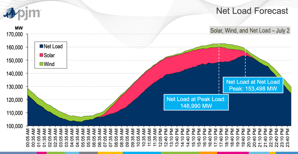
Already across the state, behind-the-meter solar is shaving off peak power demand. On the afternoon of July 2, behind-the-meter solar accounted served about 4.5 gigawatts to users, according to NYISO and Grid Status data.
Going forward, Zarelli said, the city should use its purchasing and planning power — as it did with CHPE — for projects like resurrecting Clean Path. “We need to be starting now. Maybe it’s not by 2030, but soon after we could be getting the benefit of that.”
“Battery developers started to see interconnection costs that were around 30 or 40 times what is standard,” Patrick Robbins, director of the Utility Customers Association told me. “It just means that new battery projects completely don’t pencil out and so we have a de facto moratorium on new [battery] projects.”
Advocates for solar and storage have blamed Con Edison for the city’s slow progress there, claiming that changes in the interconnection process have made it essentially cost prohibitive for battery storage developers to move forward on new projects.
Some of these fights have landed in front of New York’s Public Service Commission. In a filing, the city cited data from Con Edison showing that “the interconnection costs for some projects … have increased by thousands of percent,” citing one project whose interconnection costs jumped from $640,000 to over $35 million due to changes in how Con Edison attributed grid costs from new projects.
"Battery storage is essential to New York's clean energy future, and Con Edison strongly supports the development of energy storage when projects are deployed at the right locations, at the appropriate scale, and with operating parameters that provide the greatest benefit to customers and the electric grid,” a Con Edison spokesperson told me. “Because grid constraints vary across our system — from neighborhood‑level distribution lines to major transmission corridors — the location of a battery ultimately determines how much benefit it can deliver to the grid and to customers.”
There were 115 megawatts of battery storage operational in New York City at the end of last year, according to Con Edison, and 865 megawatts of projects with interconnection agreements. Peak load in the region is about 10,000 megawatts, meaning that these new projects would meaningfully alter the way the utility serves its customers.
Con Edison has claimed in a regulatory filing that the concentration of projects could lead to “significant impacts from BESS charging on infrastructure upstream of primary feeders,” necessitating the changes to its interconnection process. The city claimed in its filing that the added cost has “understandably chilled ongoing development activity at a time when New York City needs more supply resources capable of serving peak demand.”
When I reached out to the Mayor’s Office of Climate & Environmental Justice about the dispute, I received a statement in return from New York City Chief Climate Officer Louise Yeung: “Expanding battery storage capacity will be critical to New York City’s clean energy future, as extreme climate events continue to strain our grid system,” she said. “The City is working across agencies and communities to ensure battery energy storage projects are deployed safely and can provide reliable power when New Yorkers need it most.”
As for residential solar and storage, it will likely take years for those distributed resources to become a regular part of New York City’s energy landscape. There’s only one fully permitted and approved residential storage system allowed in New York City, which was installed earlier this year by Brooklyn Solar Works. Negotiating approvals with city agencies including the Department of Buildings and the New York City Fire Department took around six years, the company’s vice president of sales, Steve Nelson, told me.
“It’s New York City. We’re expecting there to be some level of bureaucracy and some lift to get that stuff approved,” Nelson said. “But what we also lack is a ready, readily accessible residential battery that meets the criteria that these departments have set.”
All that adds up to both a practical and a political gap for decarbonization, Zarelli told me.
“Batteries are a great way to connect the climate agenda and the affordability agenda, and it’s in the mayor’s control — it’s the regulatory apparatus at FDNY,” he said. “That’s a big near-term play that I think would make a big difference.”
Earlier this year, New York City Councilmember James Gennaro introduced a bill to amend the fire code to relax some battery storage permitting and safety requirements. But that still leaves the city’s decarbonization advocates with many big fish to fry.
“It’s a challenging future that’s still out in front of us, and how to navigate that is really difficult. But it’d be good if we were actually aligned on what our goals were as a society,” Zarelli said.


 Here comes the sun.PJM