January is one of the worst months of the year for wildfires — in southern Australia. Not in the metro area of Los Angeles, where it is, technically, supposed to be the rainy season.
But try telling a fire that it’s unseasonal.
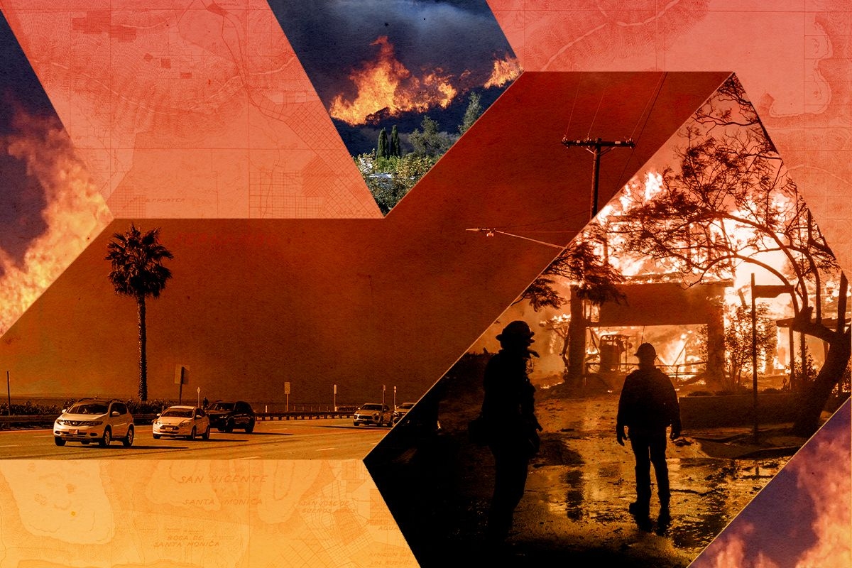
At the time of this writing, three wildfires are burning in the Los Angeles area, mostly uncontained: the nearly 3,000-acre Palisades fire in the hills between Santa Monica and Malibu; the 500-acre Hurst fire in Sylmar, northwest of downtown L.A.; and the 2,300-acre Eaton fire outside of Pasadena. The fire has destroyed more than 1,000 buildings — including, apparently, the home of reality TV royals Heidi Montag and Spencer Pratt — and at least two people have died. Emergency management officials told an additional 30,000 people to evacuate immediately, a number that is likely to climb as dry, windy conditions worsen throughout the day on the West Coast. Though it’s still early in the unfolding disaster, forecasters expect fire weather to continue through at least Thursday, and some experts are already saying the event may end up being the costliest wildfire on record.
It’s not the case, however, that this unusual storm has taken emergency management or the public by surprise. “We’ve been advertising this event for several days and talking about how serious it could be starting last week,” Kristen Allison, a fire management specialist with the Southern California Geographic Area Coordination Center, told me. Given the high Santa Ana winds —which, with their 100-mile-per-hour gusts, were strong enough to blow unimpeded over the San Gabriel mountains and hit typically sheltered areas like Pasadena — and the low humidity, forecasters saw all the classic warning signs of wildfire well in advance.
It’s not the wind or dry air that is so atypical for January, though. “We haven’t had significant rain since April, so we’ve been dry for eight or nine months,” Allison went on. “Our fuels are basically bone dry at this point.”
And there is a lot of fuel waiting to burn after the region’s wet spring — a dangerous situation created by the see-sawing between extremes that is typical of climate change. Earlier this year, the U.S. Drought Monitor classified many parts of the state as being in a “moderate” drought, a trend that also has strong links to climate change and will have dried out the vegetation in the hills.
Get the best of Heatmap in your inbox daily.
Making matters worse, the winter storms that usually hit the L.A. area this time of year have tracked north, soaking the Pacific Northwest and Northern California instead. L.A.’s fires, then, are “not so much a temperature story,” Max Moritz, a cooperative extension wildfire specialist at U.C. Santa Barbara’s Bren School of Environmental Science & Management, told me. “This is really more of a precipitation and climate change story.” All the landscape was ever going to need, in other words, was a spark.
It might be a long time before we discover what this particular spark was. But it also doesn’t really matter. “Once fires like this start, there is not a whole lot firefighters can do,” Neil Lareau, a professor of atmospheric science at the University of Nevada, Reno, told me. “The pre-positioning of resources — all of that was there. But you see the impossibility of the task at hand once the fires get going.”
Allison agreed that few who live in the fire-prone hills outside of Malibu or Pasadena are likely to have ignored the warnings just because they’ve otherwise been lucky lately. “People know that if we haven’t had rain in months and months and months, and we got the wind coming — they know this is fire weather,” Allison said. The lack of significant casualties so far might be attributed to the fact that as awful as the physical destruction is, this is also what southern California does, even if it’s an unusual time of year.
But Scott Capps, an atmospheric scientist and the head of Atmospheric Data Solutions, a forecasting firm, pointed out to me in an email that just because we expect fire weather, “we cannot predict where and when a wildfire ignition will happen.” As he explained, the terrain of southern California is complex and extraordinarily difficult to accurately model; in a fast-moving situation like the fires in L.A., the advantages of predicting fire weather quickly reach their limits. Especially when a wildfire starts burning between fuel-rich homes, entire neighborhoods can quickly go up in smoke.
The late author and urban theorist Mike Davis once argued that we should let Malibu burn. “After every major California blaze, homeowners and their representatives take shelter in the belief that if wildfire can’t be prevented, nonetheless, its destructiveness can be tamed,” he wrote, adding: “Yet, as a contemporary Galileo might say … ‘still it burns.’”
Davis was writing in 1998, a time when he described fire season as “late August to early October.” Many would argue now that there isn’t such a thing as a fire “season” anymore. Allison warned me that the forecast looks favorable for fires through Friday, and that “additional winds are coming next week” and “we’re not going to see rain anytime soon.” At a certain point, Davis’ wry pessimism might not seem not so crass.
Moritz, though, wanted to be clear in distinguishing between the inevitabilities. “We have built communities right up into and against flammable landscapes, so yes, it is inevitable that many of these neighborhoods are going to experience a fire,” he explained. But “is it inevitable that we would have this many home losses, or have to evacuate this many people, and who knows how many fatalities may end up emerging — is that part inevitable? No.”
Predicting fires is, of course, vitally important: Warnings and outlooks prevent deaths, promote home-hardening and resilience measures, and help encourage smooth evacuations that, in turn, keep first responders safe. But when you have an alignment of conditions like these, prediction will never equal prevention. Moritz argued that we need to move beyond “preventing” fires, anyway — it’s more important that we begin to think of land use and urban planning as public health measures. “We need to have urban design standards that explicitly address the need for more survivable communities” in southern California, he told me.
Because of the climate, because of bad luck, because of the folly of wanting to live somewhere with that perfect Pacific view — California was going to catch fire. “I think there are going to be some tragic outcomes that we hear about,” Moritz said, “and if there are any lessons that we can take away, it’s that we have to learn to coexist with this kind of inevitable natural hazard.”