You’re out of free articles.
Log in
To continue reading, log in to your account.
Create a Free Account
To unlock more free articles, please create a free account.
Sign In or Create an Account.
By continuing, you agree to the Terms of Service and acknowledge our Privacy Policy
Welcome to Heatmap
Thank you for registering with Heatmap. Climate change is one of the greatest challenges of our lives, a force reshaping our economy, our politics, and our culture. We hope to be your trusted, friendly, and insightful guide to that transformation. Please enjoy your free articles. You can check your profile here .
subscribe to get Unlimited access
Offer for a Heatmap News Unlimited Access subscription; please note that your subscription will renew automatically unless you cancel prior to renewal. Cancellation takes effect at the end of your current billing period. We will let you know in advance of any price changes. Taxes may apply. Offer terms are subject to change.
Subscribe to get unlimited Access
Hey, you are out of free articles but you are only a few clicks away from full access. Subscribe below and take advantage of our introductory offer.
subscribe to get Unlimited access
Offer for a Heatmap News Unlimited Access subscription; please note that your subscription will renew automatically unless you cancel prior to renewal. Cancellation takes effect at the end of your current billing period. We will let you know in advance of any price changes. Taxes may apply. Offer terms are subject to change.
Create Your Account
Please Enter Your Password
Forgot your password?
Please enter the email address you use for your account so we can send you a link to reset your password:
The oldest climate story isn’t about a wildfire or a hurricane, a heat wave or a drought. It’s about a flood.
“The deluge is terrifying not just for its destructive capacity but also for the way it undoes all that has been accomplished, brings us back to the fathomless chaos of beginning,” The New Yorker’s Avi Steinberg writes of this most primordial human fear, the story of which has been echoed across cultures and religions from the Mesopotamian Epic of Gilgamesh to the Bible’s Old Testament to the Ancient Greek Deucalion Myth to stories told by Native peoples across North America. It might also be humankind’s oldest cautionary tale: When the rain starts and the waters begin to rise, pay attention.
In the United States, floods are the deadliest extreme weather phenomenon after heat waves. In particular, flash floods — which the National Oceanic and Atmospheric Administration distinguishes as flooding that “begins within 6 hours, and often within 3 hours, of ... heavy rainfall” — often take people by surprise, or are dangerously underestimated.
With Hurricane Hilary threatening to dump potentially a year’s worth of rain on parts of the southwestern United States in the span of 72 hours, learning how to react to rising waters ahead of time can be life-saving. This is what you need to know.
Unlike learning your personal wildfire risk, which is relatively easy, it can be frustrating to try to figure out the flood risk of your home.
FEMA publishes flood maps (you can search by your address here), but the shading key can be hard to make out and I had difficulty getting the images to load. I had my best luck navigating to this version of the map, clicking on the location I was interested in, then clicking to the second page of the pop-up information, where you will see “Flood Hazard Zones” followed by a letter. The letters B, C, and X designate moderate- to low-risk flood areas (though the risk in these locations is not non-existent!) while high-risk areas are marked with A or V.
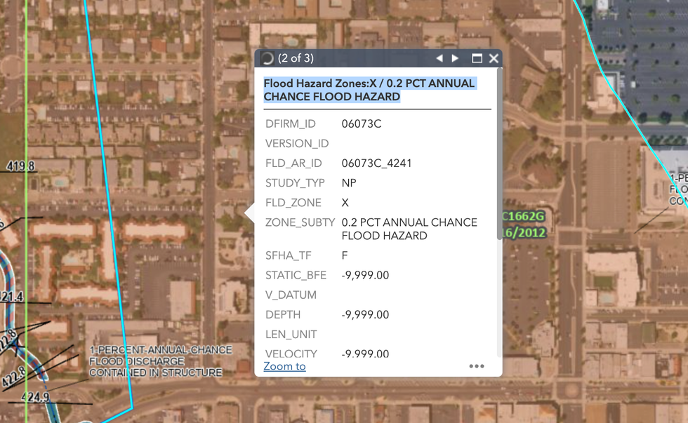
An example of where to find your individual flood hazard zone on the FEMA flood map.FEMA
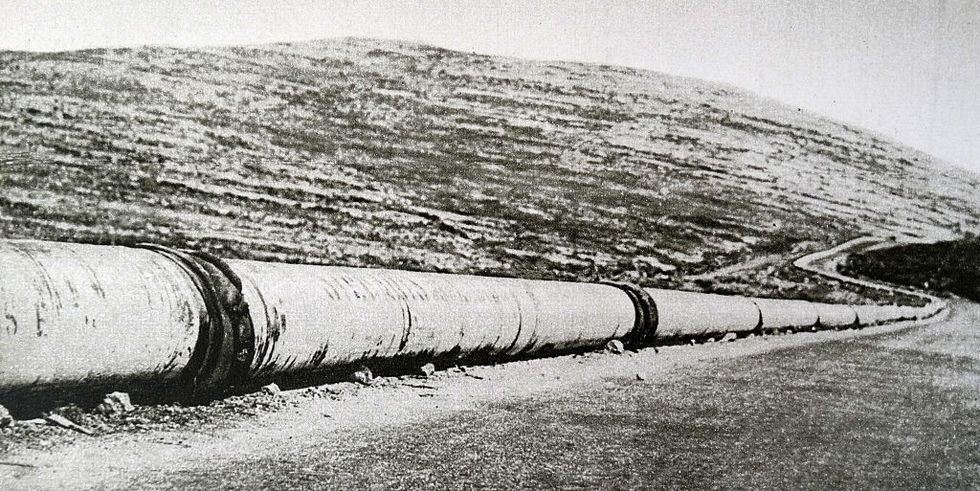
Personally, I preferred the clear information laid out at RiskFactor.com. The website told me my neighborhood’s risk (I live by the river in New York City, so mine is “moderate”) and the number of properties in the area that have a “greater than ... 26% chance of being severely affected by flooding over the next 30 years” (for my neighborhood, 16%!). The website will even estimate the “max depth of flooding” of a specific home or building for this year and in the next 30 years.
If you are in a moderate- to high-risk area on either map, you should take steps to prepare for a flash flood. Even if you score lower, you might want to consider preparing your house because minimal risk doesn’t denote zero risk.
Either way, you should read the below section about “what to do if you’re in a car during a flash flood,” since such a scenario can happen to anyone.
You don’t have to wait for a flash flood warning to begin to prepare for the worst. But if you’re in a situation where you can anticipate flooding — like much of Southern California, Nevada, and southwestern Arizona can right now — you should prepare ahead of time to run errands so you won’t need to leave the house during the storm. Keep in mind, the best way to stay safe during a flash flood is to not encounter the flood in the first place.
Make sure you have enough food for several days, as well as enough pet food for your animals. Also be sure to pick up any prescriptions or medications you might need. Anticipate any other reasons why you might need to leave your home and try to prevent or limit them ahead of time.
Confirm that the contents of your “go bag” or emergency evacuation kit are up-to-date. Here’s a generic checklist of what should go in it, as well as a version in Spanish.
Check the batteries in your flashlights and charge backup batteries for electronics like cell phones, in case the power goes out.
Clean up your yard if you have time; secure outdoor furniture so it doesn’t get blown around.
Prepare electricity-free entertainment options (now is the time to start brushing up on gin rummy).
Check on neighbors or relatives who might not be aware of the coming storm or have made preparations yet.
I can't believe I have to write this, but absolutely do not order Doordash or Uber Eats or food or products from any other courier service during flash flood conditions. Doing so puts other people in direct danger. Your ramen craving can be satisfied later.
Never wait out a storm in a basement or an apartment that is below ground level if you live in an area with moderate to high flood risk; move to a higher floor or find a different location to shelter in. Even if your home or basement has been okay in previous rainstorms, major flood events can overwhelm city sewer systems and back up water into areas it hasn’t reached before. As Reza Khanbilvardi, a professor of civil engineering and hydrology at City College of New York, told Gothamist after Hurricane Ida killed dozens in New York, New Jersey, and Connecticut in 2021, “Apartments in cellars and basements can be death traps.” Paved urban areas can be especially dangerous in these conditions.
Follow potential evacuation alerts on your phone or on a radio (yes, they still exist!). Sign up for alerts now if you haven’t already.
Seal your important documents in a gallon-size freezer bag or other waterproof bag if you anticipate needing to evacuate, The New York Times suggests.
Unplug electronics and move any valuables to higher floors or locations if you have time to prepare for an evacuation.
If water enters your home, evacuate immediately with your go bag. Do not wait or try to retrieve any additional items. One of the most common ways people get hurt during flash floods is by waiting too long to evacuate. Use your best judgment — if it feels safer to climb to a higher floor than to try to drive to higher ground, do so, but avoid sheltering in an attic where FEMA warns you could get trapped. “Go on the roof only if necessary,” FEMA writes, and “signal for help.”
Do not attempt to walk or swim through floodwaters. Six inches of moving water is enough to knock an adult off their feet. Electrocution is also the second-biggest cause of death during a flood after drowning; never attempt to turn off a circuit breaker box or touch appliances if you are wet or standing in water.
If you come in contact with floodwaters, be sure to wash that area of your body very well when you reach safety.
If at all possible, avoid driving during flash flood conditions. Of course, this isn’t always possible — often people are out when they get caught in a storm. The National Weather Service reports that nearly half of flash-flood fatalities are vehicle-related and the “majority” of victims are male.
First and foremost, never, ever drive through floodwaters or around a roadblock or barrier. “Turn around, don’t drown” is a well-worn NWS slogan for a reason. Just 6 inches of flowing water can move a car and just 12 inches can carry it away — it doesn’t matter how good of a driver you are.
Additionally, even if the water looks shallow, it might not be. “Do not attempt to cross a flooded road even if the car in front of you made it through,” meteorologist Bonnie Schneider writes in her book Extreme Weather.
If your car stalls in water, first responders want you to remember “seatbelt, windows, out.” Do not waste valuable time trying to call 911 and wait for rescue. Unbuckle immediately so you are free to move. Then roll down the windows so that if the car’s electrical system shorts out, you still have a means of escape. (As a backup, buy a “Lifehammer” to punch your way through the window and out of your car. If you do not have a Lifehammer or something similar, the pointy metal ends of a headrest can work in a pinch, The New York Times reports.)
At this point, there is “no right answer,” Joseph Bushra, the medical director with Narberth Ambulance, told WHYY. You need to assess the situation. If it is safe to exit your car and escape to higher ground, do so, but plan your path before getting out of the car and remember, just 6 inches of water can knock an adult over.
If it is not safe to try to make it to higher ground, then you need to get on top of your car. Turn on your hazard lights to make the car visible to first responders. Evacuate children first, starting with the oldest child, and tell them to hang onto whatever they can, The New York Times advises. Once you have evacuated and are on top of your car, then call 911.
It’s not called a “worst-case scenario” for nothing. So what do you do if you end up in the water during a flash flood?
Your number one priority should be to try to get out of the water as quickly as you can. Climb a tree, a building, a car or truck, or head toward any available higher ground.
If you are forced to swim, move perpendicular to the current. Keep in mind this is a last possible resort: “People need to realize that most people who lose their footing in a flash flood don’t get out,” Julie Munger, the founder of Sierra Rescue International, told The New York Times.
If swimming to safety isn’t possible, the Riverside County Fire Department recommends orienting your body so you’re on your back, with your feet down-current, so you can use them to move debris out of the way. “Most victims in swift water die when they get pinned against obstacles, or get trapped in submerged debris and vegetation,” the department writes. Get out of the water or on top of something as quickly as possible — and hold on tight.
Log in
To continue reading, log in to your account.
Create a Free Account
To unlock more free articles, please create a free account.
Why killing a government climate database could essentially gut a tax credit
The Trump administration’s bid to end an Environmental Protection Agency program may essentially block any company — even an oil firm — from accessing federal subsidies for capturing carbon or producing hydrogen fuel.
On Friday, the Environmental Protection Agency proposed that it would stop collecting and publishing greenhouse gas emissions data from thousands of refineries, power plants, and factories across the country.
The Trump administration argues that the scheme, known as the Greenhouse Gas Reporting Program, costs more than $2 billion and isn’t legally required under the Clean Air Act. Lee Zeldin, the EPA administrator, described the program as “nothing more than bureaucratic red tape that does nothing to improve air quality.”
But the program is more important than the Trump administration lets on. It’s true that the policy, which required more than 8,000 different facilities around the country to report their emissions, helped the EPA and outside analysts estimate the country’s annual greenhouse gas emissions.
But it did more than that. Over the past decade, the program had essentially become the master database of carbon pollution and emissions policy across the American economy. “Essentially everything the federal government does related to emissions reductions is dependent on the [Greenhouse Gas Reporting Program],” Jack Andreasen Cavanaugh, a fellow at the Center on Global Energy Policy at Columbia University, told me.
That means other federal programs — including those that Republicans in Congress have championed — have come to rely on the EPA database.
Among those programs: the federal tax credit for capturing and using carbon dioxide. Republicans recently increased the size of that subsidy, nicknamed 45Q after a section of the tax code, for companies that turn captured carbon into another product or use it to make oil wells more productive. Those changes were passed in President Trump’s big tax and spending law over the summer.
But Zeldin’s scheme to end the Greenhouse Gas Reporting Program would place that subsidy off limits for the foreseeable future. Under federal law, companies can only claim the 45Q tax credit if they file technical details to the EPA’s emissions reporting program.
Another federal tax credit, for companies that use carbon capture to produce hydrogen fuel, also depends on the Greenhouse Gas Reporting Program. That subsidy hasn’t received the same friendly treatment from Republicans, and it will now phase out in 2028.
The EPA program is “the primary mechanism by which companies investing in and deploying carbon capture and hydrogen projects quantify the CO2 that they’re sequestering, such that they qualify for tax incentives,” Jane Flegal, a former Biden administration appointee who worked on industrial emissions policy, told me. She is now the executive director of the Blue Horizons Foundation.
“The only way for private capital to be put to work to deploy American carbon capture and hydrogen projects is to quantify the carbon dioxide that they’re sequestering, in some way,” she added. That’s what the EPA program does: It confirms that companies are storing or using as much carbon as they claim they are to the IRS.
The Greenhouse Gas Reporting Program is “how the IRS communicates with the EPA” when companies claim the 45Q credit, Cavanaugh said. “The IRS obviously has taxpayer-sensitive information, so they’re not able to give information to the EPA about who or what is claiming the credit.” The existence of the database lets the EPA then automatically provide information to the IRS, so that no confidential tax information is disclosed.
Zeldin’s announcement that the EPA would phase out the program has alarmed companies planning on using the tax credit. In a statement, the Carbon Capture Coalition — an alliance of oil companies, manufacturers, startups, and NGOs — called the reporting program the “regulatory backbone” of the carbon capture tax credit.
“It is not an understatement that the long-term success of the carbon management industry rests on the robust reporting mechanisms” in the EPA’s program, the group said.
Killing the EPA program could hurt American companies in other ways. Right now, companies that trade with European firms depend on the EPA data to pass muster with the EU’s carbon border adjustment tax. It’s unclear how they would fare in a world with no EPA data.
It could also sideline GOP proposals. Senator Bill Cassidy, a Republican from Louisiana, has suggested that imports to the United States should pay a foreign pollution fee — essentially, a way of accounting for the implicit subsidy of China’s dirty energy system. But the data to comply with that law would likely come from the EPA’s greenhouse gas database, too.
Ending the EPA database wouldn’t necessarily spell permanent doom for the carbon capture tax credit, but it would make it much harder to use in the years to come. In order to re-open the tax credit for applications, the Treasury Department, the Energy Department, the Interior Department, and the EPA would have to write new rules for companies that claim the 45Q credit. These rules would go to the end of the long list of regulations that the Treasury Department must write after Trump’s spending law transformed the tax code.
That could take years — and it could sideline projects now under construction. “There are now billions of dollars being invested by the private sector and the government in these technologies, where the U.S. is positioned to lead globally,” Flegal said. Changing the rules would “undermine any way for the companies to succeed.”
Ditching the EPA database, however, very well could doom carbon capture-based hydrogen projects. Under the terms of Trump’s tax law, companies that want to claim the hydrogen credit must begin construction on their projects by 2028.
The Trump administration seems to believe, too, that gutting the EPA database may require new rules for the carbon capture tax credit. When asked for comment, an EPA spokesperson pointed me to a line in the agency’s proposal: “We anticipate that the Treasury Department and the IRS may need to revise the regulation,” the legal proposal says. “The EPA expects that such amendments could allow for different options for stakeholders to potentially qualify for tax credits.”
The EPA spokesperson then encouraged me to ask the Treasury Department for anything more about “specific implications.”
Paradise, California, is snatching up high-risk properties to create a defensive perimeter and prevent the town from burning again.
The 2018 Camp Fire was the deadliest wildfire in California’s history, wiping out 90% of the structures in the mountain town of Paradise and killing at least 85 people in a matter of hours. Investigations afterward found that Paradise’s town planners had ignored warnings of the fire risk to its residents and forgone common-sense preparations that would have saved lives. In the years since, the Camp Fire has consequently become a cautionary tale for similar communities in high-risk wildfire areas — places like Chinese Camp, a small historic landmark in the Sierra Nevada foothills that dramatically burned to the ground last week as part of the nearly 14,000-acre TCU September Lightning Complex.
More recently, Paradise has also become a model for how a town can rebuild wisely after a wildfire. At least some of that is due to the work of Dan Efseaff, the director of the Paradise Recreation and Park District, who has launched a program to identify and acquire some of the highest-risk, hardest-to-access properties in the Camp Fire burn scar. Though he has a limited total operating budget of around $5.5 million and relies heavily on the charity of local property owners (he’s currently in the process of applying for a $15 million grant with a $5 million match for the program) Efseaff has nevertheless managed to build the beginning of a defensible buffer of managed parkland around Paradise that could potentially buy the town time in the case of a future wildfire.
In order to better understand how communities can build back smarter after — or, ideally, before — a catastrophic fire, I spoke with Efseaff about his work in Paradise and how other communities might be able to replicate it. Our conversation has been lightly edited and condensed for clarity.
Do you live in Paradise? Were you there during the Camp Fire?
I actually live in Chico. We’ve lived here since the mid-‘90s, but I have a long connection to Paradise; I’ve worked for the district since 2017. I’m also a sea kayak instructor and during the Camp Fire, I was in South Carolina for a training. I was away from the phone until I got back at the end of the day and saw it blowing up with everything.
I have triplet daughters who were attending Butte College at the time, and they needed to be evacuated. There was a lot of uncertainty that day. But it gave me some perspective, because I couldn’t get back for two days. It gave me a chance to think, “Okay, what’s our response going to be?” Looking two days out, it was like: That would have been payroll, let’s get people together, and then let’s figure out what we’re going to do two weeks and two months from now.
It also got my mind thinking about what we would have done going backwards. If you’d had two weeks to prepare, you would have gotten your go-bag together, you’d have come up with your evacuation route — that type of thing. But when you run the movie backwards on what you would have done differently if you had two years or two decades, it would include prepping the landscape, making some safer community defensible space. That’s what got me started.
Was it your idea to buy up the high-risk properties in the burn scar?
I would say I adapted it. Everyone wants to say it was their idea, but I’ll tell you where it came from: Pre-fire, the thinking was that it would make sense for the town to have a perimeter trail from a recreation standpoint. But I was also trying to pitch it as a good idea from a fuel standpoint, so that if there was a wildfire, you could respond to it. Certainly, the idea took on a whole other dimension after the Camp Fire.
I’m a restoration ecologist, so I’ve done a lot of river floodplain work. There are a lot of analogies there. The trend has been to give nature a little bit more room: You’re not going to stop a flood, but you can minimize damage to human infrastructure. Putting levees too close to the river makes them more prone to failing and puts people at risk — but if you can set the levee back a little bit, it gives the flood waters room to go through. That’s why I thought we need a little bit of a buffer in Paradise and some protection around the community. We need a transition between an area that is going to burn, and that we can let burn, but not in a way that is catastrophic.
How hard has it been to find willing sellers? Do most people in the area want to rebuild — or need to because of their mortgages?
Ironically, the biggest challenge for us is finding adequate funding. A lot of the property we have so far has been donated to us. It’s probably upwards of — oh, let’s see, at least half a dozen properties have been donated, probably close to 200 acres at this point.
We are applying for some federal grants right now, and we’ll see how that goes. What’s evolved quite a bit on this in recent years, though, is that — because we’ve done some modeling — instead of thinking of the buffer as areas that are managed uniformly around the community, we’re much more strategic. These fire events are wind-driven, and there are only a couple of directions where the wind blows sufficiently long enough and powerful enough for the other conditions to fall into play. That’s not to say other events couldn’t happen, but we’re going after the most likely events that would cause catastrophic fires, and that would be from the Diablo winds, or north winds, that come through our area. That was what happened in the Camp Fire scenario, and another one our models caught what sure looked a lot like the [2024] Park Fire.
One thing that I want to make clear is that some people think, “Oh, this is a fire break. It’s devoid of vegetation.” No, what we’re talking about is a well-managed habitat. These are shaded fuel breaks. You maintain the big trees, you get rid of the ladder fuels, and you get rid of the dead wood that’s on the ground. We have good examples with our partners, like the Butte Fire Safe Council, on how this works, and it looks like it helped protect the community of Cohasset during the Park Fire. They did some work on some strips there, and the fire essentially dropped to the ground before it came to Paradise Lake. You didn’t have an aerial tanker dropping retardant, you didn’t have a $2-million-per-day fire crew out there doing work. It was modest work done early and in the right place that actually changed the behavior of the fire.
Tell me a little more about the modeling you’ve been doing.
We looked at fire pathways with a group called XyloPlan out of the Bay Area. The concept is that you simulate a series of ignitions with certain wind conditions, terrain, and vegetation. The model looked very much like a Camp Fire scenario; it followed the same pathway, going towards the community in a little gulch that channeled high winds. You need to interrupt that pathway — and that doesn’t necessarily mean creating an area devoid of vegetation, but if you have these areas where the fire behavior changes and drops down to the ground, then it slows the travel. I found this hard to believe, but in the modeling results, in a scenario like the Camp Fire, it could buy you up to eight hours. With modern California firefighting, you could empty out the community in a systematic way in that time. You could have a vigorous fire response. You could have aircraft potentially ready. It’s a game-changing situation, rather than the 30 minutes Paradise had when the Camp Fire started.
How does this work when you’re dealing with private property owners, though? How do you convince them to move or donate their land?
We’re a Park and Recreation District so we don’t have regulatory authority. We are just trying to run with a good idea with the properties that we have so far — those from willing donors mostly, but there have been a couple of sales. If we’re unable to get federal funding or state support, though, I ultimately think this idea will still have to be here — whether it’s five, 10, 15, or 50 years from now. We have to manage this area in a comprehensive way.
Private property rights are very important, and we don’t want to impinge on that. And yet, what a person does on their property has a huge impact on the 30,000 people who may be downwind of them. It’s an unusual situation: In a hurricane, if you have a hurricane-rated roof and your neighbor doesn’t, and theirs blows off, you feel sorry for your neighbor but it’s probably not going to harm your property much. In a wildfire, what your neighbor has done with the wood, or how they treat vegetation, has a significant impact on your home and whether your family is going to survive. It’s a fundamentally different kind of event than some of the other disasters we look at.
Do you have any advice for community leaders who might want to consider creating buffer zones or something similar to what you’re doing in Paradise?
Start today. You have to think about these things with some urgency, but they’re not something people think about until it happens. Paradise, for many decades, did not have a single escaped wildfire make it into the community. Then, overnight, the community is essentially wiped out. But in so many places, these events are foreseeable; we’re just not wired to think about them or prepare for them.
Buffers around communities make a lot of sense, even from a road network standpoint. Even from a trash pickup standpoint. You don’t think about this, but if your community is really strung out, making it a little more thoughtfully laid out also makes it more economically viable to provide services to people. Some things we look for now are long roads that don’t have any connections — that were one-way in and no way out. I don’t think [the traffic jams and deaths in] Paradise would have happened with what we know now, but I kind of think [authorities] did know better beforehand. It just wasn’t economically viable at the time; they didn’t think it was a big deal, but they built the roads anyway. We can be doing a lot of things smarter.
A war of attrition is now turning in opponents’ favor.
A solar developer’s defeat in Massachusetts last week reveals just how much stronger project opponents are on the battlefield after the de facto repeal of the Inflation Reduction Act.
Last week, solar developer PureSky pulled five projects under development around the western Massachusetts town of Shutesbury. PureSky’s facilities had been in the works for years and would together represent what the developer has claimed would be one of the state’s largest solar projects thus far. In a statement, the company laid blame on “broader policy and regulatory headwinds,” including the state’s existing renewables incentives not keeping pace with rising costs and “federal policy updates,” which PureSky said were “making it harder to finance projects like those proposed near Shutesbury.”
But tucked in its press release was an admission from the company’s vice president of development Derek Moretz: this was also about the town, which had enacted a bylaw significantly restricting solar development that the company was until recently fighting vigorously in court.
“There are very few areas in the Commonwealth that are feasible to reach its clean energy goals,” Moretz stated. “We respect the Town’s conservation go als, but it is clear that systemic reforms are needed for Massachusetts to source its own energy.”
This stems from a story that probably sounds familiar: after proposing the projects, PureSky began reckoning with a burgeoning opposition campaign centered around nature conservation. Led by a fresh opposition group, Smart Solar Shutesbury, activists successfully pushed the town to drastically curtail development in 2023, pointing to the amount of forest acreage that would potentially be cleared in order to construct the projects. The town had previously not permitted facilities larger than 15 acres, but the fresh change went further, essentially banning battery storage and solar projects in most areas.
When this first happened, the state Attorney General’s office actually had PureSky’s back, challenging the legality of the bylaw that would block construction. And PureSky filed a lawsuit that was, until recently, ongoing with no signs of stopping. But last week, shortly after the Treasury Department unveiled its rules for implementing Trump’s new tax and spending law, which basically repealed the Inflation Reduction Act, PureSky settled with the town and dropped the lawsuit – and the projects went away along with the court fight.
What does this tell us? Well, things out in the country must be getting quite bleak for solar developers in areas with strident and locked-in opposition that could be costly to fight. Where before project developers might have been able to stomach the struggle, money talks – and the dollars are starting to tell executives to lay down their arms.
The picture gets worse on the macro level: On Monday, the Solar Energy Industries Association released a report declaring that federal policy changes brought about by phasing out federal tax incentives would put the U.S. at risk of losing upwards of 55 gigawatts of solar project development by 2030, representing a loss of more than 20 percent of the project pipeline.
But the trade group said most of that total – 44 gigawatts – was linked specifically to the Trump administration’s decision to halt federal permitting for renewable energy facilities, a decision that may impact generation out west but has little-to-know bearing on most large solar projects because those are almost always on private land.
Heatmap Pro can tell us how much is at stake here. To give you a sense of perspective, across the U.S., over 81 gigawatts worth of renewable energy projects are being contested right now, with non-Western states – the Northeast, South and Midwest – making up almost 60% of that potential capacity.
If historical trends hold, you’d expect a staggering 49% of those projects to be canceled. That would be on top of the totals SEIA suggests could be at risk from new Trump permitting policies.
I suspect the rate of cancellations in the face of project opposition will increase. And if this policy landscape is helping activists kill projects in blue states in desperate need of power, like Massachusetts, then the future may be more difficult to swallow than we can imagine at the moment.