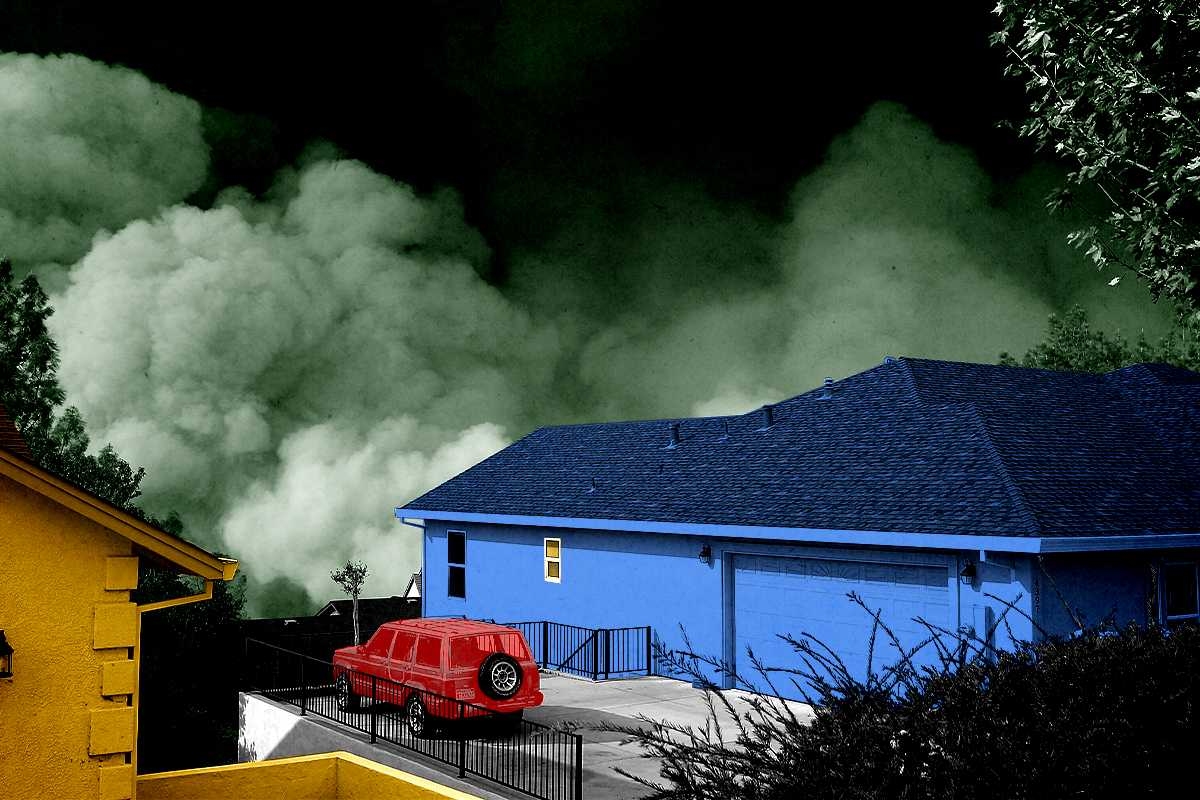
The 2018 Camp Fire was the deadliest wildfire in California’s history, wiping out 90% of the structures in the mountain town of Paradise and killing at least 85 people in a matter of hours. Investigations afterward found that Paradise’s town planners had ignored warnings of the fire risk to its residents and forgone common-sense preparations that would have saved lives. In the years since, the Camp Fire has consequently become a cautionary tale for similar communities in high-risk wildfire areas — places like Chinese Camp, a small historic landmark in the Sierra Nevada foothills that dramatically burned to the ground last week as part of the nearly 14,000-acre TCU September Lightning Complex.
More recently, Paradise has also become a model for how a town can rebuild wisely after a wildfire. At least some of that is due to the work of Dan Efseaff, the director of the Paradise Recreation and Park District, who has launched a program to identify and acquire some of the highest-risk, hardest-to-access properties in the Camp Fire burn scar. Though he has a limited total operating budget of around $5.5 million and relies heavily on the charity of local property owners (he’s currently in the process of applying for a $15 million grant with a $5 million match for the program) Efseaff has nevertheless managed to build the beginning of a defensible buffer of managed parkland around Paradise that could potentially buy the town time in the case of a future wildfire.
In order to better understand how communities can build back smarter after — or, ideally, before — a catastrophic fire, I spoke with Efseaff about his work in Paradise and how other communities might be able to replicate it. Our conversation has been lightly edited and condensed for clarity.
Do you live in Paradise? Were you there during the Camp Fire?
I actually live in Chico. We’ve lived here since the mid-‘90s, but I have a long connection to Paradise; I’ve worked for the district since 2017. I’m also a sea kayak instructor and during the Camp Fire, I was in South Carolina for a training. I was away from the phone until I got back at the end of the day and saw it blowing up with everything.
I have triplet daughters who were attending Butte College at the time, and they needed to be evacuated. There was a lot of uncertainty that day. But it gave me some perspective, because I couldn’t get back for two days. It gave me a chance to think, “Okay, what’s our response going to be?” Looking two days out, it was like: That would have been payroll, let’s get people together, and then let’s figure out what we’re going to do two weeks and two months from now.
It also got my mind thinking about what we would have done going backwards. If you’d had two weeks to prepare, you would have gotten your go-bag together, you’d have come up with your evacuation route — that type of thing. But when you run the movie backwards on what you would have done differently if you had two years or two decades, it would include prepping the landscape, making some safer community defensible space. That’s what got me started.
Was it your idea to buy up the high-risk properties in the burn scar?
I would say I adapted it. Everyone wants to say it was their idea, but I’ll tell you where it came from: Pre-fire, the thinking was that it would make sense for the town to have a perimeter trail from a recreation standpoint. But I was also trying to pitch it as a good idea from a fuel standpoint, so that if there was a wildfire, you could respond to it. Certainly, the idea took on a whole other dimension after the Camp Fire.
I’m a restoration ecologist, so I’ve done a lot of river floodplain work. There are a lot of analogies there. The trend has been to give nature a little bit more room: You’re not going to stop a flood, but you can minimize damage to human infrastructure. Putting levees too close to the river makes them more prone to failing and puts people at risk — but if you can set the levee back a little bit, it gives the flood waters room to go through. That’s why I thought we need a little bit of a buffer in Paradise and some protection around the community. We need a transition between an area that is going to burn, and that we can let burn, but not in a way that is catastrophic.
How hard has it been to find willing sellers? Do most people in the area want to rebuild — or need to because of their mortgages?
Ironically, the biggest challenge for us is finding adequate funding. A lot of the property we have so far has been donated to us. It’s probably upwards of — oh, let’s see, at least half a dozen properties have been donated, probably close to 200 acres at this point.
We are applying for some federal grants right now, and we’ll see how that goes. What’s evolved quite a bit on this in recent years, though, is that — because we’ve done some modeling — instead of thinking of the buffer as areas that are managed uniformly around the community, we’re much more strategic. These fire events are wind-driven, and there are only a couple of directions where the wind blows sufficiently long enough and powerful enough for the other conditions to fall into play. That’s not to say other events couldn’t happen, but we’re going after the most likely events that would cause catastrophic fires, and that would be from the Diablo winds, or north winds, that come through our area. That was what happened in the Camp Fire scenario, and another one our models caught what sure looked a lot like the [2024] Park Fire.
One thing that I want to make clear is that some people think, “Oh, this is a fire break. It’s devoid of vegetation.” No, what we’re talking about is a well-managed habitat. These are shaded fuel breaks. You maintain the big trees, you get rid of the ladder fuels, and you get rid of the dead wood that’s on the ground. We have good examples with our partners, like the Butte Fire Safe Council, on how this works, and it looks like it helped protect the community of Cohasset during the Park Fire. They did some work on some strips there, and the fire essentially dropped to the ground before it came to Paradise Lake. You didn’t have an aerial tanker dropping retardant, you didn’t have a $2-million-per-day fire crew out there doing work. It was modest work done early and in the right place that actually changed the behavior of the fire.
Tell me a little more about the modeling you’ve been doing.
We looked at fire pathways with a group called XyloPlan out of the Bay Area. The concept is that you simulate a series of ignitions with certain wind conditions, terrain, and vegetation. The model looked very much like a Camp Fire scenario; it followed the same pathway, going towards the community in a little gulch that channeled high winds. You need to interrupt that pathway — and that doesn’t necessarily mean creating an area devoid of vegetation, but if you have these areas where the fire behavior changes and drops down to the ground, then it slows the travel. I found this hard to believe, but in the modeling results, in a scenario like the Camp Fire, it could buy you up to eight hours. With modern California firefighting, you could empty out the community in a systematic way in that time. You could have a vigorous fire response. You could have aircraft potentially ready. It’s a game-changing situation, rather than the 30 minutes Paradise had when the Camp Fire started.
How does this work when you’re dealing with private property owners, though? How do you convince them to move or donate their land?
We’re a Park and Recreation District so we don’t have regulatory authority. We are just trying to run with a good idea with the properties that we have so far — those from willing donors mostly, but there have been a couple of sales. If we’re unable to get federal funding or state support, though, I ultimately think this idea will still have to be here — whether it’s five, 10, 15, or 50 years from now. We have to manage this area in a comprehensive way.
Private property rights are very important, and we don’t want to impinge on that. And yet, what a person does on their property has a huge impact on the 30,000 people who may be downwind of them. It’s an unusual situation: In a hurricane, if you have a hurricane-rated roof and your neighbor doesn’t, and theirs blows off, you feel sorry for your neighbor but it’s probably not going to harm your property much. In a wildfire, what your neighbor has done with the wood, or how they treat vegetation, has a significant impact on your home and whether your family is going to survive. It’s a fundamentally different kind of event than some of the other disasters we look at.
Do you have any advice for community leaders who might want to consider creating buffer zones or something similar to what you’re doing in Paradise?
Start today. You have to think about these things with some urgency, but they’re not something people think about until it happens. Paradise, for many decades, did not have a single escaped wildfire make it into the community. Then, overnight, the community is essentially wiped out. But in so many places, these events are foreseeable; we’re just not wired to think about them or prepare for them.
Buffers around communities make a lot of sense, even from a road network standpoint. Even from a trash pickup standpoint. You don’t think about this, but if your community is really strung out, making it a little more thoughtfully laid out also makes it more economically viable to provide services to people. Some things we look for now are long roads that don’t have any connections — that were one-way in and no way out. I don’t think [the traffic jams and deaths in] Paradise would have happened with what we know now, but I kind of think [authorities] did know better beforehand. It just wasn’t economically viable at the time; they didn’t think it was a big deal, but they built the roads anyway. We can be doing a lot of things smarter.


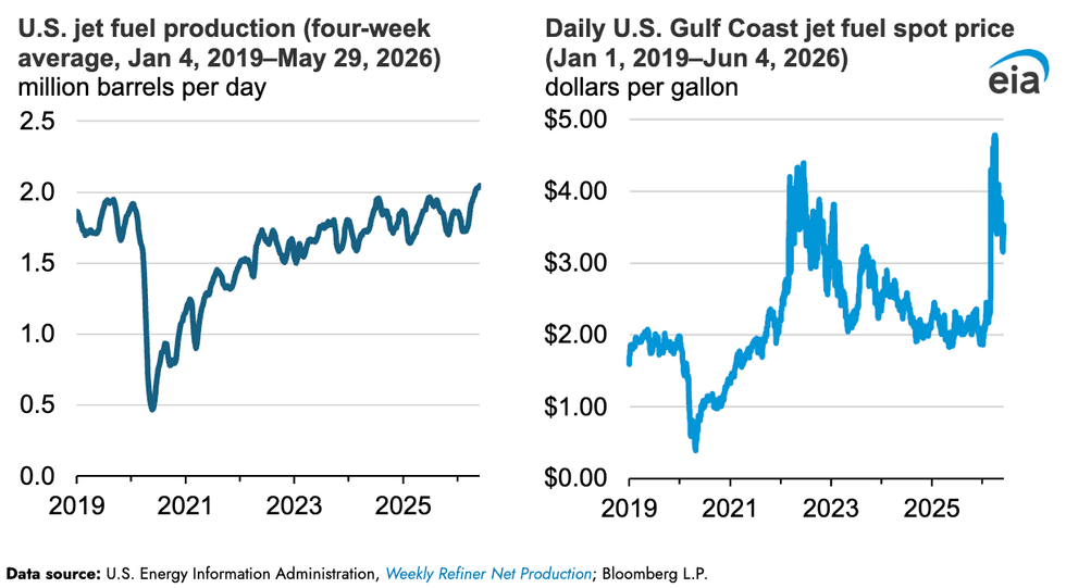 While spot prices are coming back down, they're still far above recent years. EIA