The heat is chilling out this week, meaning today’s update is a short one. If you’re in the Northeast, start dreaming of pumpkins and hot cocoa. If you live farther south … keep running that AC a little longer.
Fall is in sight — for some
Those in the Northeast can start airing out their sweaters this week. According to Paul Pastelok, AccuWeather senior meteorologist, a long-lasting jet stream should bring temperatures 5 to 10 degrees Fahrenheit below historical averages through the end of August. The region can also expect some precipitation and stronger storms, which will likely bring down temperatures even more.
The Pacific Northwest will also get fall-like weather this week, Pastelok told me, which will move into the Great Lakes and the Ohio Valley on Thursday. For much of the South and the Gulf Coast, however, forecasts are not looking as optimistic. Pastelok told me it’s possible that both Albuquerque, New Mexico and Lubbock, Texas will break heat records this week, getting well into the 90s and 100s, respectively.
After a brief respite, the heat will also return to the western Dakotas, Nebraska, Wyoming, and southeast Montana. Some parts of the Pacific Northwest that started the week feeling fall-ish might end it back in summer, as temperatures creep back up on the eastern side of the region. By Friday, Texas will have it worst.
Park Fire slows down
The Park Fire seems to have finally halted — it hasn’t grown past 429,000 acres burned since last week. Containment is now at 53%. and no new counties have been affected. “I think there's a reasonable chance that the fire has largely reached its final footprint,” said Climate scientist of the University of California, Los Angeles Daniel Swain during a live briefing on Friday.
After experiencing its hottest July ever, California will finally get a break from the heat this week as the low pressure along the northwest coast will send cool air down into California, Pastelok told me. “The combination of smoke and westerly winds will cool northern California, as well as the coastal areas down to southern California,” he said.
But that doesn’t mean fire conditions are going away, Swain explained. As long as things stay windy and dry, the risk will remain, and a new heat wave arriving around the end of August could up the danger even higher.
Greece’s worst wildfire of the year almost reached Athens
Gigantic wildfires in Greece stopped just shy of Athens. The fire spread incredibly quickly last week due to powerful winds, with flames as high as 80 feet — the mayor of Kifisia, Vasilis Xypolitas, told CNN that at one point, the fire was moving faster than cars. Thousands of residents had to be evacuated.
While the flames have since died down, they burned through almost 260,000 acres, causing extensive damage to cities and villages. Houses, schools, and hospitals have been completely destroyed and many residents might have to wait weeks before electricity is restored. One death has been confirmed.
The cause of the fire has not yet been determined, but Greece has been suffering through a particularly hot and dry summer — prime conditions for relentless fires. This year, the country saw its hottest June and July on record.
Another heat wave in the Balkans
Southeastern Europe has recently seen temperatures above 100 degrees during a heat wave that is expected to persist this week. This is the latest heat wave to hit Romania, which has already suffered through drought and extreme weather this summer. While some rain is predicted for the country this week, temperatures will continue to run above average
Bosnia has also been particularly hard hit, and farmers there have noticed a significant impact to production this year. Around Bijeljina, where most of the country’s grain production takes place, farmers estimate that half their crops have been damaged due to the heat. The whole country has seen little to no precipitation this summer, with temperatures constantly above 95 degrees.




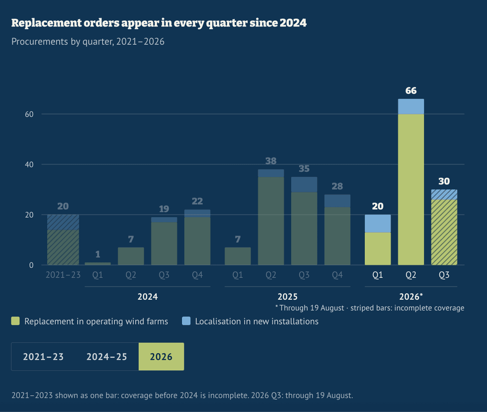 The great localization push of 2026. OSW
 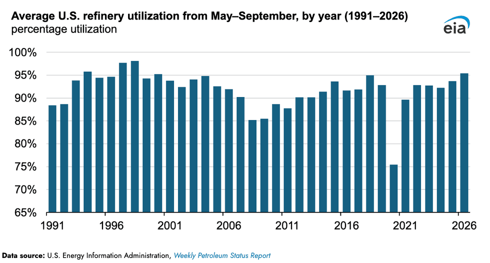 The 1990s are back. EIA