Sign In or Create an Account.

By continuing, you agree to the Terms of Service and acknowledge our Privacy Policy

Sparks

Why the World Needs Yet Another Methane Satellite

Carbon Mapper’s ultra-precise Tanager-1 is headed to space.

Methane pollution.
Heatmap Illustration/Carbon Mapper

Yet another methane satellite is launching into orbit Friday, as early as 11:19 a.m. Pacific time, on a SpaceX rocket. Developed by a coalition of public and private partners and led by the nonprofit Carbon Mapper, its precision imaging helps fill a gap in the methane detection universe and complements the abilities of MethaneSAT, the Environmental Defense Fund-developed, Google-backed satellite launched back in March.

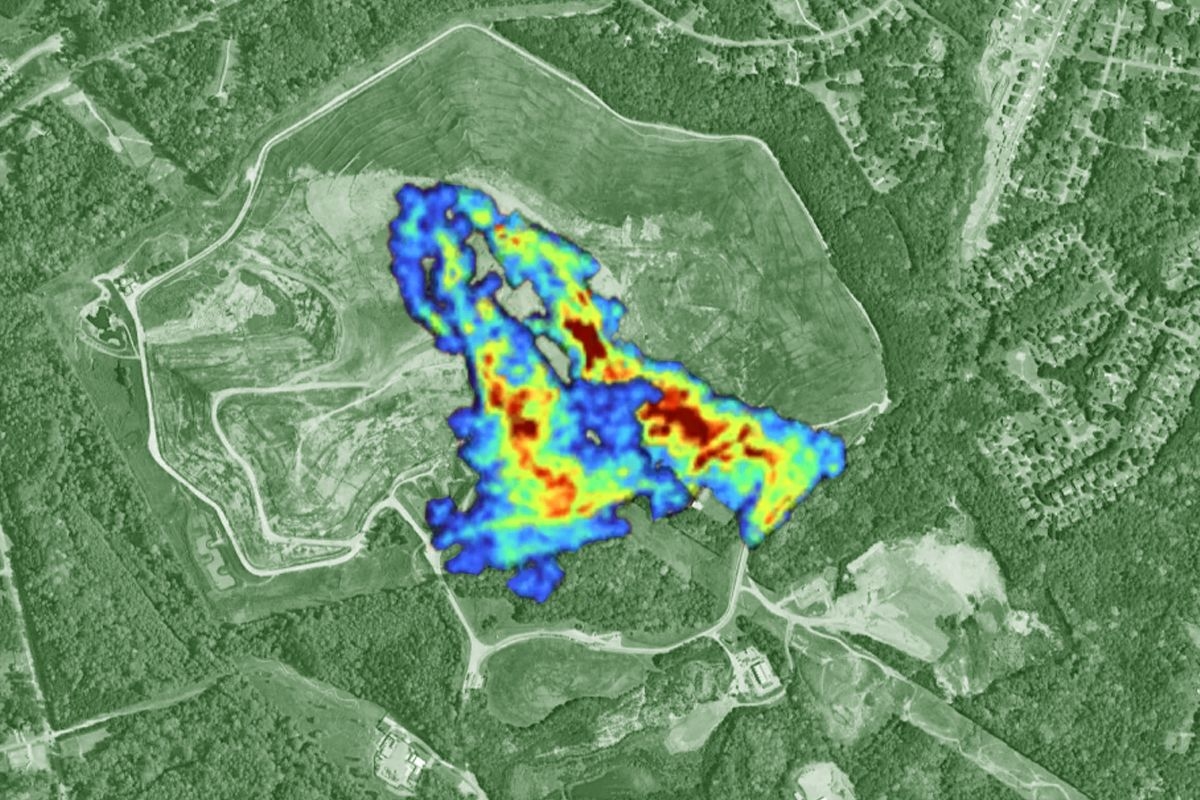
Riley Duren, CEO of Carbon Mapper, likens his company’s satellite to a telephoto lens, saying it “has a resolution that's about 10 times higher than the MethaneSAT instrument” — although the tradeoff is that the field of view is about 10 times smaller. The ultimate goal is to identify “super-emitters” of methane and carbon dioxide at the facility level. So while MethaneSAT can detect the total emissions emanating from a particular basin, state, or country, Carbon Mapper can zoom in to figure out what’s going on within 50 meters of accuracy so that operators and regulators can be notified.

Both companies use an imaging technology known as spectroscopy, which involves splitting the light reflected by Earth’s surface into its constituent wavelengths. Methane and carbon dioxide each have their own spectroscopic signature. “It's not unlike being able to perceive the distinction in human fingerprints,” Duren told me.

The Carbon Mapper Coalition satellite, called Tanager-1, came from a partnership between Planet Labs, which developed the satellite, and NASA’s Jet Propulsion Laboratory, which developed the particular spectrometer used onboard. Duren helped create the tech during his nearly 28-year career at JPL, where his research revealed the outsized importance of super-emitters. That helped inspire Duren to found Carbon Mapper in 2020, though until now the organization has mostly done suborbital aerial surveys to track methane and carbon dioxide emissions.

Promisingly, he’s found that distributing his team’s findings often leads to a rapid response. “When we've shared our data with oil and gas companies, landfill operators, and regulators, what they tell us is nearly half of the emissions that we're reporting were previously unknown,” Duren told me. “And in many cases, they can quickly repair them.”

The data from these surveys is publicly accessible on the Carbon Mapper data portal, and the data from Tanager-1 will be published there as well. In addition to Planet Labs and JPL, other coalition partners include the California Air Resources Board, University of Arizona, Arizona State University, and RMI. To date, Carbon Mapper has raised over $130 million in philanthropic funding, from donors including the High Tide Foundation, Bloomberg Philanthropies, and the Grantham Foundation for the Protection of the Environment.

Ultimately, Carbon Mapper aims to launch a constellation of more than 10 satellites, which together will detect and track up to 90% of high-emitting methane sources with near-daily frequency. But this will require funding beyond what the philanthropic sector is likely to pony up.

“Scaling up this to the full constellation and sustaining it will hinge on the ability of governments and the private sector to pay for data,” Duren told me. (MethaneSAT is also philanthropically supported.) “We're hopeful that as these programs scale up and we demonstrate their utility and the regulators depend on them, that we'll see governments begin to match what philanthropy has started,” Durian said.

If you want to watch the launch live, you can do so here.

Green

You’re out of free articles.

Subscribe today to experience Heatmap’s expert analysis 
of climate change, clean energy, and sustainability.
To continue reading
Create a free account or sign in to unlock more free articles.
or
Please enter an email address
By continuing, you agree to the Terms of Service and acknowledge our Privacy Policy
Sparks

How Hurricane Melissa Got So Strong So Fast

The storm currently battering Jamaica is the third Category 5 to form in the Atlantic Ocean this year, matching the previous record.

Hurricane Melissa.
Heatmap Illustration/Getty Images

As Hurricane Melissa cuts its slow, deadly path across Jamaica on its way to Cuba, meteorologists have been left to marvel and puzzle over its “rapid intensification” — from around 70 miles per hour winds on Sunday to 185 on Tuesday, from tropical storm to Category 5 hurricane in just a few days, from Category 2 occurring in less than 24 hours.

The storm is “one of the most powerful hurricane landfalls on record in the Atlantic basin,” the National Weather Service said Tuesday afternoon. Though the NWS expected “continued weakening” as the storm crossed Jamaica, “Melissa is expected to reach southeastern Cuba as an extremely dangerous major hurricane, and it will still be a strong hurricane when it moves across the southeastern Bahamas.”

Keep reading...Show less
Sparks

New York’s Largest Battery Project Has Been Canceled

Fullmark Energy quietly shuttered Swiftsure, a planned 650-megawatt energy storage system on Staten Island.

Curtis Sliwa.
Heatmap Illustration/Getty Images

The biggest battery project in New York has been canceled in a major victory for the nascent nationwide grassroots movement against energy storage development.

It’s still a mystery why exactly the developer of Staten Island’s Swiftsure project, Fullmark Energy (formerly known as Hecate), pulled the plug. We do know a few key details: First, Fullmark did not announce publicly that it was killing the project, instead quietly submitting a short, one-page withdrawal letter to the New York State Department of Public Service. That letter, which is publicly available, is dated August 18 of this year, meaning that the move formally occurred two months ago. Still, nobody in Staten Island seems to have known until late Friday afternoon when local publication SI Advance first reported the withdrawal.

Keep reading...Show less
Blue
Sparks

Major Renewables Nonprofit Cuts a Third of Staff After Trump Slashes Funding

The lost federal grants represent about half the organization’s budget.

The DOE wrecking ball.
Heatmap Illustration/Getty Images

The Interstate Renewable Energy Council, a decades-old nonprofit that provides technical expertise to cities across the country building out renewable clean energy projects, issued a dramatic plea for private donations in order to stay afloat after it says federal funding was suddenly slashed by the Trump administration.

IREC’s executive director Chris Nichols said in an email to all of the organization’s supporters that it has “already been forced to lay off many of our high-performing staff members” after millions of federal dollars to three of its programs were eliminated in the Trump administration’s shutdown-related funding cuts last week. Nichols said the administration nixed the funding simply because the nonprofit’s corporation was registered in New York, and without regard for IREC’s work with countless cities and towns in Republican-led states. (Look no further than this map of local governments who receive the program’s zero-cost solar siting policy assistance to see just how politically diverse the recipients are.)

Keep reading...Show less
Yellow