For the past three years, our planet’s climate patterns have been ruled by a surprisingly long “triple-dip” La Niña. But a regime change is coming: La Niña is finally over.
One-third of the pattern of shifting winds and ocean temperatures along the Pacific that meteorologists call the El Niño-Southern Oscillation, or ENSO, La Niña is known for cooler temperatures and strong easterly winds. These come together to create extra-long, extra-destructive hurricane seasons, like the ones we’ve seen over the past few years, and parching the Southwest with drought.
Its counterpart, the El Niño, does the opposite, causing ocean temperatures to rise and winds to slow or even change direction. The northern United States and Canada become dryer than usual, and the Gulf Coast and South, at least in theory, see more rain and floods.
Usually, each climate pattern lasts somewhere between nine to 12 months, and we can sometimes go years without seeing either one.
While climate scientists think an El Niño is likely coming this summer, we are, for now, in the final third of ENSO, enjoying a period of relative calm that’s simply known as ENSO Neutral. This is when our planet’s climate patterns settle back to “normal,” with surface temperatures on the Pacific mostly hewing close to average and weaker easterly winds than during a La Niña.
But don’t be fooled: Calm on a global scale doesn’t necessarily mean calm on the ground.
Every year, the National Oceanic and Atmospheric Administration, or NOAA, publishes a report called the spring outlook, which is exactly what it sounds like: a late-winter prediction of what the season ahead will look like. This year’s report, published Thursday, makes the coming spring look like a mixed bag.
First, the good news: All the rain and snow slamming into California over the last few months has, at least temporarily, helped ease the La Niña-enhanced drought that’s gripped the West for years. According to the report, “winter precipitation, combined with recent storms, wiped out exceptional and extreme drought in California for the first time since 2020, and is expected to further improve drought conditions this spring.”
But easing the drought has come at a cost. Wind, floods, mudslides, and piles upon piles of snow have devastated communities and knocked out power for hundreds of thousands in California — and more rain is on the way. Once all the snow that’s fallen on mountains across the country starts to melt, NOAA predicts floods will come to other parts of the country as well. "Approximately 44% of the U.S. is at risk for flooding this spring,” said Ed Clark, director of NOAA’s National Water Center, in the spring outlook. Unlike the floods that hit California over the past few months, which were mostly due to torrential rain, spring floods are likely to come from rivers saturated with snowmelt overtopping their banks.
 Image courtesy of NOAA.
But snowmelt should bring some much-needed relief to parts of the Colorado River basin, which is in the midst of a drought that’s brought Lake Powell and Lake Mead to historic lows. Yet as droughts ease in some places, they look likely to spread or worsen in others. NOAA expects our “Neutral” spring to bring above-average temperatures and potential droughts to parts of New Mexico and Washington State that are currently drought-free.
For a period of relative calm, that sounds pretty chaotic. But an El Niño might be even worse — it tends to bring periods of warming, and some think the arrival of one this summer could be a preview of what the world would be like under 1.5 degrees Celsius of warming.
Enjoy our chaotic Neutral moment while it lasts.


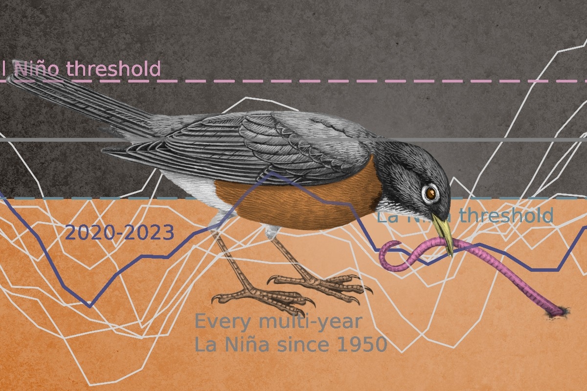
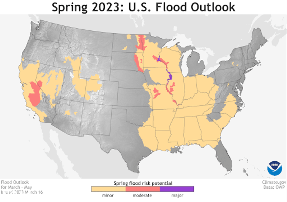 Image courtesy of NOAA.