Tropical Storm Barry was, by all measures, a boring storm. “Blink and you missed it,” as a piece in Yale Climate Connections put it after Barry formed, then dissipated over 24 hours in late June, having never sustained wind speeds higher than 45 miles per hour. The tropical storm’s main impact, it seemed at the time, was “heavy rains of three to six inches, which likely caused minor flooding” in Tampico, Mexico, where it made landfall.
But a few days later, U.S. meteorologists started to get concerned. The remnants of Barry had swirled northward, pooling wet Gulf air over southern and central Texas and elevating the atmospheric moisture to reach or exceed record levels for July. “Like a waterlogged sponge perched precariously overhead, all the atmosphere needed was a catalyst to wring out the extreme levels of water vapor,” meteorologist Mike Lowry wrote.
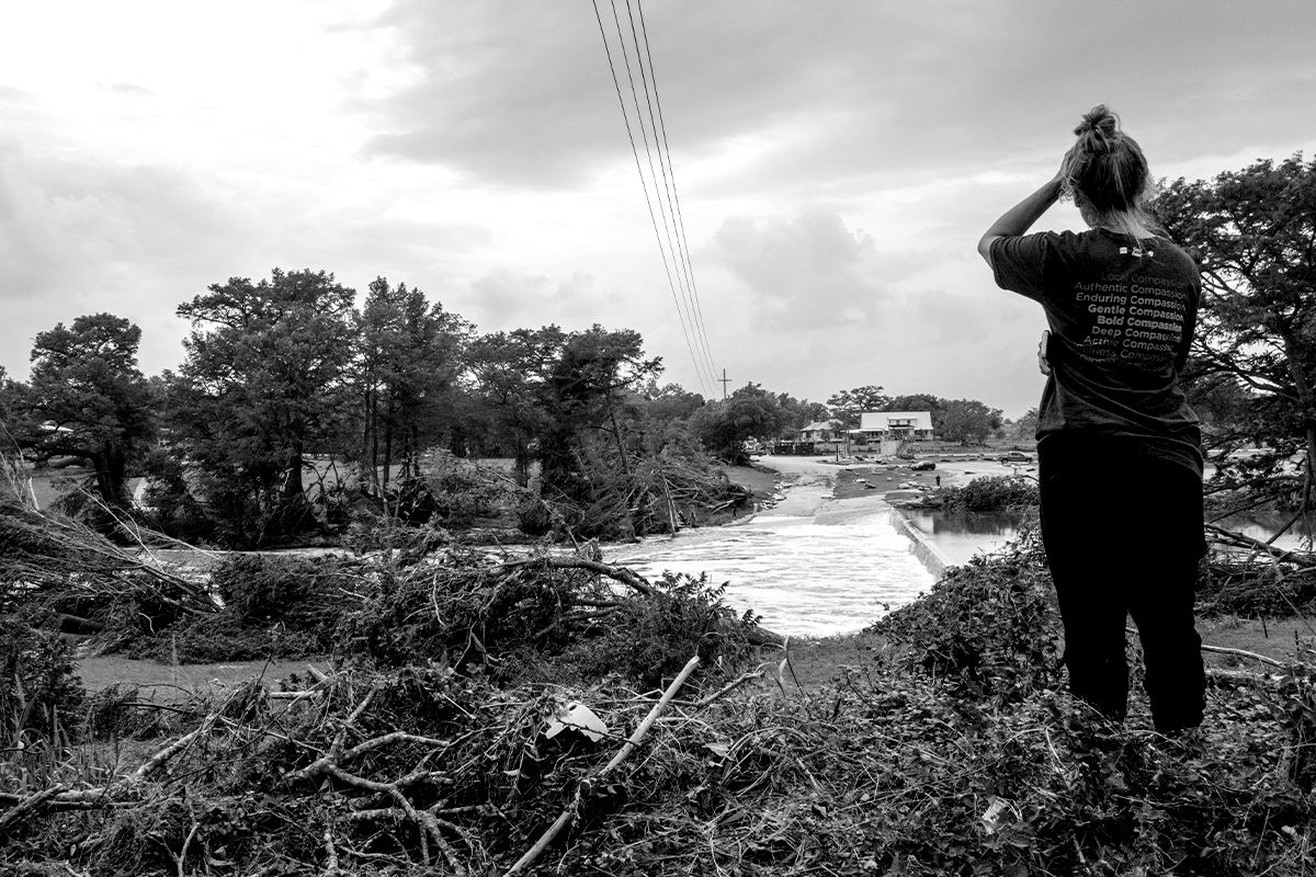
More than 100 people — many of them children — ultimately died as extreme rainfall caused the Guadalupe River to rise 34 feet in 90 minutes. But the tragedy was “not really a failure of meteorology,” UCLA and UC Agriculture and Natural Resources climate scientist Daniel Swain said during a public “Office Hours” review of the disaster on Monday. The National Weather Service in San Antonio and Austin first warned the public of the potential for heavy rain on Sunday, June 29 — five days before the floods crested. The agency followed that with a flood watch warning for the Kerrville area on Thursday, July 3, then issued an additional 21 warnings, culminating just after 1 a.m. on Friday, July 4, with a wireless emergency alert sent to the phones of residents, campers, and RVers along the Guadalupe River.
The NWS alerts were both timely and accurate, and even correctly predicted an expected rainfall rate of 2 to 3 inches per hour. If it were possible to consider the science alone, the official response might have been deemed a success.
Of all the storm systems, convective storms — like thunderstorms, hail, tornadoes, and extreme rainstorms — are some of the most difficult to forecast. “We don’t have very good observations of some of these fine-scale weather extremes,” Swain told me after office hours were over, in reference to severe meteorological events that are often relatively short-lived and occur in small geographic areas. “We only know a tornado occurred, for example, if people report it and the Weather Service meteorologists go out afterward and look to see if there’s a circular, radial damage pattern.” A hurricane, by contrast, spans hundreds of miles and is visible from space.
Global weather models, which predict conditions at a planetary scale, are relatively coarse in their spatial resolution and “did not do the best job with this event,” Swain said during his office hours. “They predicted some rain, locally heavy, but nothing anywhere near what transpired.” (And before you ask — artificial intelligence-powered weather models were among the worst at predicting the Texas floods.)
Over the past decade or so, however, due to the unique convective storm risks in the United States, the National Oceanic and Atmospheric Administration and other meteorological agencies have developed specialized high resolution convection-resolving models to better represent and forecast extreme thunderstorms and rainstorms.
NOAA’s cutting-edge specialized models “got this right,” Swain told me of the Texas storms. “Those were the models that alerted the local weather service and the NOAA Weather Prediction Center of the potential for an extreme rain event. That is why the flash flood watches were issued so early, and why there was so much advanced knowledge.”
Writing for The Eyewall, meteorologist Matt Lanza concurred with Swain’s assessment: “By Thursday morning, the [high resolution] model showed as much as 10 to 13 inches in parts of Texas,” he wrote. “By Thursday evening, that was as much as 20 inches. So the [high resolution] model upped the ante all day.”
To be any more accurate than they ultimately were on the Texas floods, meteorologists would have needed the ability to predict the precise location and volume of rainfall of an individual thunderstorm cell. Although models can provide a fairly accurate picture of the general area where a storm will form, the best current science still can’t achieve that level of precision more than a few hours in advance of a given event.
Climate change itself is another factor making storm behavior even less predictable. “If it weren’t so hot outside, if it wasn’t so humid, if the atmosphere wasn’t holding all that water, then [the system] would have rained and marched along as the storm drifted,” Claudia Benitez-Nelson, an expert on flooding at the University of South Carolina, told me. Instead, slow and low prevailing winds caused the system to stall, pinning it over the same worst-case-scenario location at the confluence of the Hill Country rivers for hours and challenging the limits of science and forecasting.
Though it’s tempting to blame the Trump administration cuts to the staff and budget of the NWS for the tragedy, the local NWS actually had more forecasters on hand than usual in its local field office ahead of the storm, in anticipation of potential disaster. Any budget cuts to the NWS, while potentially disastrous, would not go into effect until fiscal year 2026.
The proposed 2026 budget for NOAA, however, would zero out the upkeep of the models, as well as shutter the National Severe Storms Laboratory in Norman, Oklahoma, which studies thunderstorms and rainstorms, such as the one in Texas. And due to the proprietary, U.S.-specific nature of the high-resolution models, there is no one coming to our rescue if they’re eliminated or degraded by the cuts.
The impending cuts are alarming to the scientists charged with maintaining and adjusting the models to ensure maximum accuracy, too. Computationally, it’s no small task to keep them running 24 hours a day, every day of the year. A weather model doesn’t simply run on its own indefinitely, but rather requires large data transfers as well as intakes of new conditions from its network of observation stations to remain reliable. Although the NOAA high-resolution models have been in use for about a decade, yearly updates keep the programs on the cutting edge of weather science; without constant tweaks, the models’ accuracy slowly degrades as the atmosphere changes and information and technologies become outdated.
It’s difficult to imagine that the Texas floods could have been more catastrophic, and yet the NOAA models and NWS warnings and alerts undoubtedly saved lives. Still, local Texas authorities have attempted to pass the blame, claiming they weren’t adequately informed of the dangers by forecasters. The picture will become clearer as reporting continues to probe why the flood-prone region did not have warning sirens, why camp counselors did not have their phones to receive overnight NWS alarms, why there were not more flood gauges on the rivers, and what, if anything, local officials could have done to save more people. Still, given what is scientifically possible at this stage of modeling, “This was not a forecast failure relative to scientific or weather prediction best practices. That much is clear,” Swain said.
As the climate warms and extreme rainfall events increase as a result, however, it will become ever more crucial to have access to cutting-edge weather models. “What I want to bring attention to is that this is not a one-off,” Benitez-Nelson, the flood expert at the University of South Carolina, told me. “There’s this temptation to say, ‘Oh, it’s a 100-year storm, it’s a 1,000-year storm.’”
“No,” she went on. “This is a growing pattern.”


 AirNow.gov