Meteorologists had nothing polite to say about Tropical Storm Bertha. The “weak, disorganized, and lopsided” system made initial landfall in Louisiana last week as a “hot, sheared mess,” one that forecasters doubted would reach Texas with much oomph at all. Still, the Galveston County Consolidated Drainage District — the local flood mitigation and drainage management entity for the state’s most flood-prone county — had stood at the ready, posting updates on the storm’s progress to its Facebook feed in the lead-up.
There had been action behind the scenes, too. Since this spring, the county has relied on a new “AI-powered flood warning solution” pilot program to help local administrators identify the gaps in their understanding of the county’s flood risk and monitor rising water levels in real time. In a crisis, a chatbot could even advise them on when to issue an evacuation order.
“Imagine you’re an operator and you have to tell people to leave their homes because of floods coming in,” Todd Barr, the CEO of Axonis Decision Intelligence, which has partnered with the smart water-level sensor company Simplicity Integration in Texas’ Galveston County, told me. Axonis provides AI-assisted decision-making tools to clients in a number of time-sensitive industries, and in every case, “You want a paper trail of the data you used to make the decision — the reasoning and the model you used — and our platform does all of that,” Barr went on.
Issuing evacuation notices is a famously thorny business, and one that has resulted in high-profile and high-casualty failures, including in the Paradise, California, and Maui wildfires. Particularly noteworthy were the 2025 Kerr County floods that killed more than 100 people in Texas’ Hill Country after local officials took 90 minutes to send phone alerts once they became aware of the rising river.
In many cases, particularly in more rural counties, the teams making the evacuation decisions are small and lack sufficient training not only on when to make such a call, but even on how to word it. “The people who are put in the position of issuing the messages are doing 20 other things at the same time,” Jeannette Sutton, a researcher at the University at Albany’s Emergency and Risk Communication Message Testing Lab, told me when I reported on evacuation notices after the Los Angeles fires.
As for Galveston, “100%” of the buildings on the densely populated island are at flood risk, with modeling suggesting a worst-case-scenario hurricane could produce 26 feet of storm surge. Much of the city’s stormwater infrastructure additionally predates modern climate-change-intensified rainfall probabilities, with the district in the midst of a $54 million drainage project aimed at mitigating future flooding by building a pump station and enlarging sewer lines.
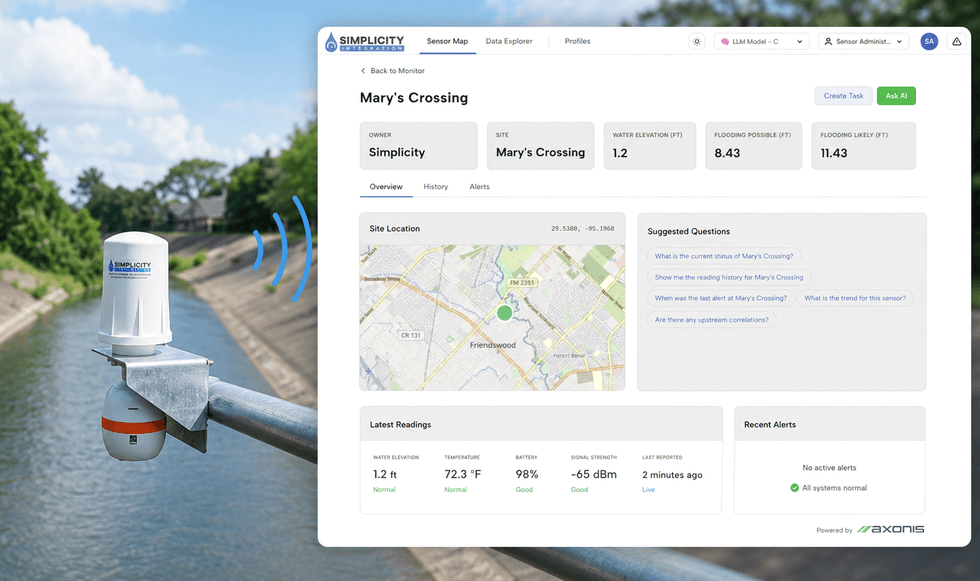
As part of the region’s ongoing resiliency work, the Galveston County Consolidated Drainage District installed seven of Simplicity’s water-level sensors —the county’s first — at locations on the mainland. (There are no sensors currently on Galveston Island proper.) Simplicity’s Axonis-powered system, SI-Ai, also pulls in data from NOAA, the U.S. Geological Survey, and Houston’s Harris County to present residents of the entire region with a live flood-risk dashboard, complete with intuitive green-yellow-red indicators to evaluate their neighborhood hazard level in real time. Operators also have their own proprietary dashboard where they can monitor sensors and are prompted to ask questions to interpret readings and open “investigations” if something appears amiss.
 Axonis/Simplicity
“If I’m the municipality, I can say, ‘Okay, here’s what the forecast is looking like and what is potentially going to happen,” Alison Reese, the COO and co-founder of Simplicity, explained to me. “Then I could ask a question like, ‘Hey, what other locations in this watershed are at high risk for flash flooding?’”
That’s where Axonis, the artificial intelligence company, comes in. “Today you would have to be like, ‘Alright! Get the weather report, quick! What’s happening? What are the sensors saying? Okay Bill, now what’s the upstream sensor saying?’” Barr said, acting out the frantic scenario of trying to source data from multiple streams at once. “All of that is what we’re automating.” (Galveston’s Office of Emergency Management is “not the POC for the flood sensor operations,” a representative told me; the drainage district oversees the Axonis-Simplicity partnership, and did not return a request for an interview. The mayor of League City, a city 35-minutes north of Galveston that is also managed by the district, has publicly criticized the SI-Ai program as a separate sensor network that duplicates the work of the Harris County Flood Control District.)
Working from the assumption that emergency managers have to parse reams of data in short periods of time — flash floods can rise as much as 10 feet in an hour — Axonis provides what is essentially a chatbot for authorities to query potential decisions ranging from road closures to evacuation notices, based on feedback from the sensors. It stops short, however, of having a dialogue box that pops up to tell operators, EVACUATE THIS NEIGHBORHOOD NOW.
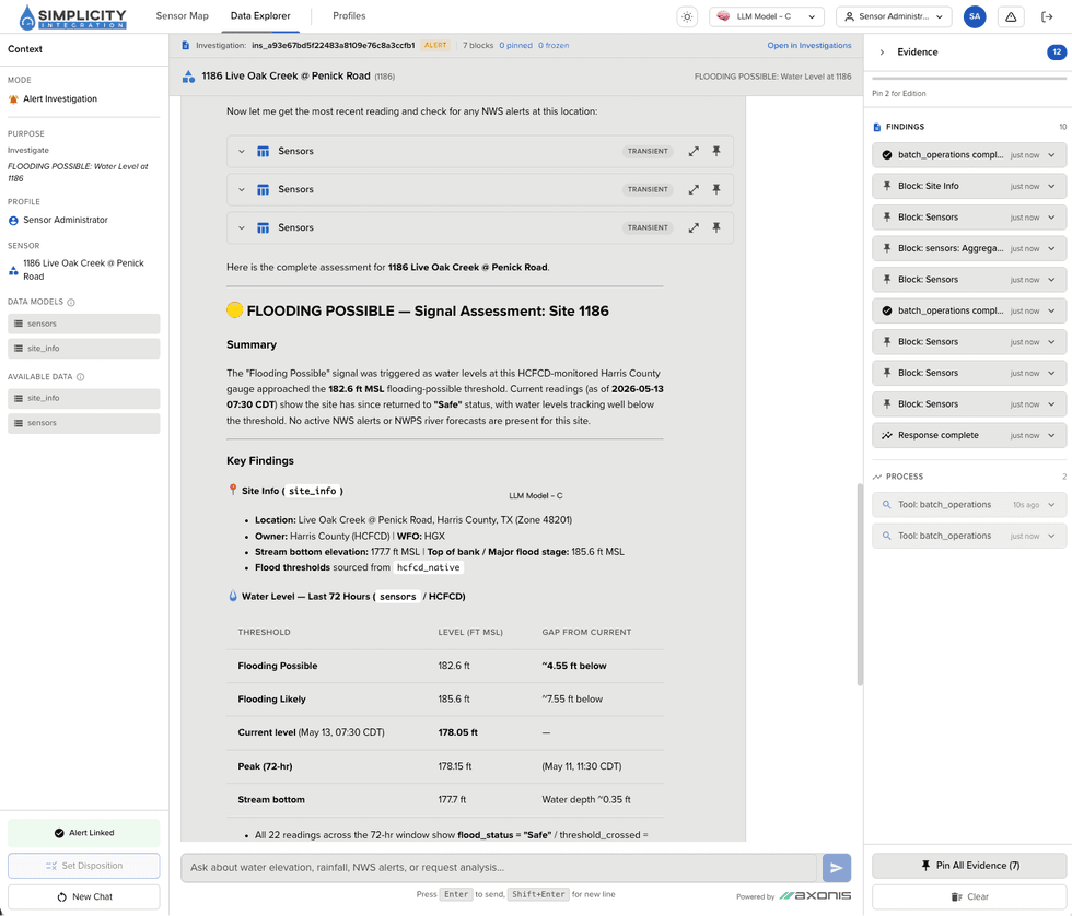
When Barr demoed the program to me, he had the tool configured to create a credit risk review memo for a would-be banking client. (Axonis also has customers in the banking and defense sectors.) The dashboard essentially functioned the same as it would for Galveston County, though, and his investigation returned the kind of simplified, emoji-studded one-sheet that users of large language model-powered AI interfaces would immediately recognize. In this case, the tool identified a “🔴Risk Alert CANDIDATE” — Barr said that would be a particular sensor, in the case of Galveston — and followed it with a summary and bullet-pointed sections breaking down “⚠️Credit Risk Indicators” and “💧Liquidity Position.” (In a screenshot of an example flood report for Simplicity, shared with me, those sections were replaced by “📍Site Location” and “💧Water Level — Last 72 Hours.” I wondered what else was possible: “🌊Historic hydraulic risk”? “💀Vulnerable Populations”? )
 Simplicity
The system then takes operators through a four-step decision-making model based on the OODA Loop, a common workflow in military contexts that involves justifying actions through evidence-based observations. “We always keep a human in the loop on these things, at least today in 2026 — though who knows in two or three years,” Barr said. He clarified in a later conversation with me, though, that “Axonis and [AI] tools should never tell you to evacuate now. It should tell you the information you need to make that decision.”
That was a point Barr stressed numerous times during our conversation: That Axonis’ chatbot is intended as a brainstorming tool or sounding board, and one that keeps a careful paper trail, “cryptographically sealing” any eventual decisions for review and attestation later. I likened it to a police body camera, and Barr didn’t dispute the similarities. “It’s an accountability tool,” he told me.
Of course, that means the burden of decision-making still falls on potentially fallible humans. I worried in particular that by sharing the responsibility with AI, human operators might get lazy or fail to properly question a decision the program might be leading them toward, particularly in an instance of hallucinated data. To the latter point, Barr told me that this is part of what Axonis is designed to address. “You can’t just take the sensor data and throw it into Claude and be like, ‘Alright, go make a decision for me.’ You need to set guard rails,” he said.
As to the former point, Barr told me the chat includes a disclaimer reminding its users that AI can make mistakes, and that the company trains its customers on how LLM technology works. “At the end of the day, it’s a tool, not a decider,” he said, although he allowed that it might be used to automatically trigger warning lights, sirens, or barriers, such as closing a flooded roadway.
I also posed the concern about complacency to Ali Mostafavi, a professor who supervises the UrbanResilience.AL Lab at Texas A&M, which researches, among other things, how artificial intelligence might be utilized in emergency contexts. Mostafavi agreed that there is always a risk in cognitive outsourcing, but that there is a “counter-argument that is also valid — that without these technologies, we have seen what can happen. We had the catastrophic floods last year in Kerr County, and if a similar technology had existed back then, an automated system could have identified the flash flood, and many young children would be alive today.”
Still, Barr told me he isn’t aware of Axonis advising in an actual evacuation order yet. While it is operational, the predictive model remains untested against its highest-stakes use case: the extremes of a climate-changed world, where formerly unthinkable outcomes may be one storm away.
“The more we can stress-test these technologies in real operational settings and use that feedback loop to improve the technologies, the better,” Mostafavi said. “But that’s easier said than done, because to have a technology implemented in an operational setting it should already be stress-tested, right?”
Bertha, though, was not that reckoning; the gusty squalls blew through Galveston last week without even disturbing the dinner reservations at the marina. But although it was already back to 90 and sunny by Monday morning on the Texas Gulf, the drainage in Galveston County, as in many places around the country, remains outdated and easily overwhelmed. One day, inevitably, the water will come. Hopefully when it does, someone or something will be watching.



 Axonis/Simplicity
 Simplicity



 The Rhine in decline. Oliver Berg/picture alliance via Getty Images