How many different ways are there to say “go”? In the emergency management world, it can seem at times like there are dozens.
Does a “level 2” alert during a wildfire, for example, mean it’s time to get out? How about a “level II” alert? Most people understand that an “evacuation order” means “you better leave now,” but how is an “evacuation warning” any different? And does a text warning that “these zones should EVACUATE NOW: SIS-5111, SIS-5108, SIS-5117…” even apply to you?
As someone who covers wildfires, I’ve been baffled not only by how difficult evacuation notices can be to parse, but also by the extent to which they vary in form and content across the United States. There is no centralized place to look up evacuation information, and even trying to follow how a single fire develops can require hopping among jargon-filled fire management websites, regional Facebook pages, and emergency department X accounts — with some anxious looking-out-the-window-at-the-approaching-pillar-of-smoke mixed in.
Google and Apple Maps don’t incorporate evacuation zone data. Third-party emergency alert programs have low subscriber rates, and official government-issued Wireless Emergency Alerts, or WEAs — messages that trigger a loud tone and vibration to all enabled phones in a specific geographic region — are often delayed, faulty, or contain bad information, none of which is ideal in a scenario where people are making life-or-death decisions. The difficulty in accessing reliable information during fast-moving disasters like wildfires is especially aggravating when you consider that nearly everyone in America owns a smartphone, i.e. a portal to all the information in the world.
So why is it still so hard to learn when and where specific evacuation notices are in place, or if they even apply to you? The answer comes down to the decentralized nature of emergency management in the United States.
Shoot the Messenger
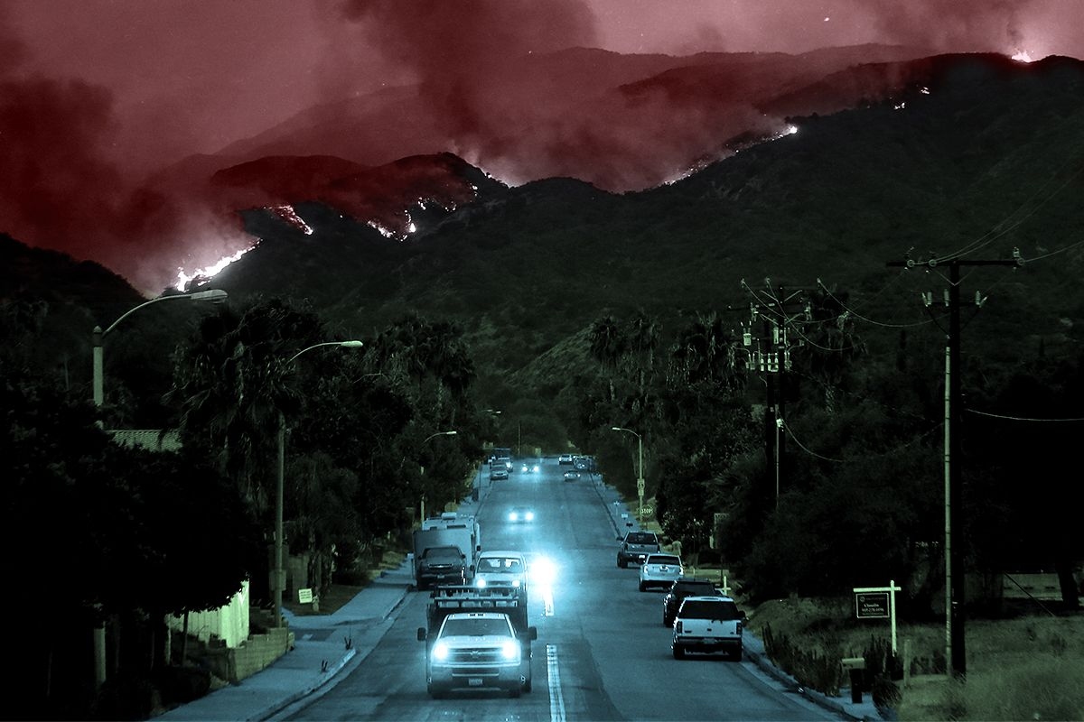
A downed power line sparks a fire on a day with a Red Flag Warning. A family driving nearby notices the column of smoke and calls to report it to 911. The first responders on the scene realize that the winds are fanning the flames toward a neighborhood, and the sheriff decides to issue a wildfire warning, communicating to the residents that they should be ready to leave at a moment’s notice. She radios her office — which is now fielding multiple calls asking for information about the smoke column — and asks for the one person in the office that day with training on the alert system to compose the message.
Scenarios like these are all too common. “The people who are put in the position of issuing the messages are doing 20 other things at the same time,” Jeannette Sutton, a researcher at the University at Albany’s Emergency and Risk Communication Message Testing Lab, told me. “They might have limited training and may not have had the opportunity to think about what the messages might contain — and then they’re told by an incident commander, Send this, and they’re like, Oh my God, what do I do?”
The primary way of issuing wildfire alerts is through WEAs, with 78,000 messages sent since 2012. Although partnerships between local emergency management officials, the Federal Emergency Management Agency, the Federal Communications Commission, and cellular and internet providers facilitate the technology, it’s local departments that determine the actual content of the message. Messaging limits force some departments to condense the details of complicated and evolving fire events into 90 characters or fewer. Typos, confusing wording, and jargon inevitably abound.
Emergency management teams often prefer to err on the side of sending too few messages rather than too many for fear of inducing information overload. “We’re so attached to our devices, whether it’s Instagram or Facebook or text messages, that it’s hard to separate the wheat from the chaff, so to speak — to make sure that we are getting the right information out there,” John Rabin, the vice president of disaster management at the consulting firm ICF International and a former assistant administrator at the Federal Emergency Management Agency, told me. “One of the challenges for local and state governments is how to bring [pertinent information] up and out, so that when they send those really important notifications for evacuations, they really resonate.”
But while writing an emergency alert is a bit of an art, active prose alone doesn’t ensure an effective evacuation message.
California’s Cal Fire has found success with the “Ready, Set, Go” program, designed by the International Association of Fire Chiefs, which uses an intuitive traffic light framework — “ready” is the prep work of putting together a go-bag and waiting for more news if a fire is in the vicinity, escalating to the “go” of the actual evacuation order. Parts of Washington and Oregon use similar three-tiered systems of evacuation “levels” ranging from 1 to 3. Other places, like Montana, rely on two-step “evacuation warnings” and “evacuation orders.”
Wisdom of Crowds
Watch Duty, a website and app that surged in popularity during the Los Angeles fires earlier this year, doesn’t worry about oversharing. Most information on Watch Duty comes from volunteers, who monitor radio scanners, check wildfire cameras, and review official law enforcement announcements, then funnel the information to the organization’s small staff, who vet it before posting. Though WatchDuty volunteers and staff — many of whom are former emergency managers or fire personnel themselves — actively review and curate the information on the app, the organization still publishes far more frequent and iterative updates than most people are used to seeing and interpreting. As a result, some users and emergency managers have criticized Watch Duty for having too much information available, as a result.
The fact that Watch Duty was downloaded more than 2 million times during the L.A. fires, though, would seem to testify to the fact that people really are hungry for information in one easy-to-locate place. The app is now available in 22 states, with more than 250 volunteers working around the clock to keep wildfire information on the app up to date. John Clarke Mills, the app’s CEO and co-founder, has said he created the app out of “spite” over the fact that the government doesn’t have a better system in place for keeping people informed on wildfires.
“I’ve not known too many situations where not having information makes it better,” Katlyn Cummings, the community manager at Watch Duty, told me. But while the app’s philosophy is “rooted in transparency and trust with our users,” Cummings stressed to me that the app’s volunteers only use official and public sources of information for their updates and never include hearsay, separating it from other crowd-sourced community apps that have proved to be less than reliable.
Still, it takes an army of a dozen full-time staff and over 200 part-time volunteers, plus an obsessively orchestrated Slack channel to centralize the wildfire and evacuation updates — which might suggest why a more official version doesn’t exist yet, either from the government or a major tech company. Google Maps currently uses AI to visualize the boundaries of wildfires, but stops short of showing users the borders of local evacuation zones (though it will route you around known road closures). A spokesperson for Google also pointed me toward a feature in Maps that shares news articles, information from local authorities, and emergency numbers when users are in “the immediate vicinity” of an actively unfolding natural disaster — a kind of do-it-yourself Watch Duty. The company declined to comment on the record about why Maps specifically excludes evacuation zones. Apple did not respond to a request for comment.
Two to Tango
There is, of course, a major caveat to the usefulness of Watch Duty.
Users of the app tend to be a self-selecting group of hyper-plugged-in digital natives who are savvy enough to download it or otherwise know to visit the website during an unfolding emergency. As Rabin, the former FEMA official, pointed out, Watch Duty users aren’t the population that first responders are most concerned about — they’re like “Boy Scouts,” he said, because they’re “always prepared.” They’re the ones who already know what’s going on. “It’s reaching the folks that aren’t paying attention that is the big challenge,” he told me.
The older adult population is the most vulnerable in cases of wildfire. Death tolls often skew disproportionately toward the elderly; of the 30 people who died in the Los Angeles fires in January, for example, all but two were over 60 or disabled, with the average age of the deceased 77, the San Francisco Chronicle reported. Part of that is because adults 65 and older are more likely to have physical impairments that make quick or unplanned evacuations challenging. Social and technological isolation are also factors — yes, almost everyone in America has a smartphone, but that includes just 80% of those 65 and older, and only 26% of the older adult population feels “very confident” using computers or smartphones. According to an extensive 2024 report on how extreme weather impacts older adults by CNA, an independent, nonprofit research organization, “Evacuation information, including orders, is not uniformly communicated in ways and via media that are accessible to older adults or those with access and functional needs.”
Sutton, the emergency warning researcher, also cautioned that more information isn’t always better. Similar to the way scary medical test results might appear in a health portal before a doctor has a chance to review them with you (and calm you down), wildfire information shared without context or interpretation from emergency management officials means the public is “making assumptions based upon what they see on Watch Duty without actually having those official messages coming from the public officials who are responsible for issuing those messages,” she said. One role of emergency managers is to translate the raw, on-the-ground information into actionable guidance. Absent that filter, panic is probable, which could lead to uncontrollable evacuation traffic or exacerbate alert fatigue. Alternatively, people might choose to opt out of future alerts or stop checking for updates.
Sutton, though she’s a strong advocate of creating standardized language for emergency alerts — “It would be wonderful if we had consistent language that was agreed upon” between departments, she told me — was ultimately skeptical of centralizing the emergency alert system under a large agency like FEMA. “The movement of wildfires is so fast, and it requires knowledge of the local communities and the local terrain as well as meteorological knowledge,” she said. “Alerts and warnings really should be local.”
The greater emphasis, Sutton stressed, should be on providing emergency managers with the training they need to communicate quickly, concisely, and effectively with the tools they already have.
The high wire act of emergency communications, though, is that while clear and regionally informed messages are critical during life-or-death situations, it also falls on residents in fire-risk areas to be ready to receive them. California first adopted the “Ready, Set, Go” framework in 2009, and it has spent an undisclosed amount of money over the years on a sustained messaging blitz to the public. (Cal Fire’s “land use planning and public education budget is estimated at $16 million, and funds things like the updated ad spots it released as recently as this August.) Still, there is evidence that even that has not been enough — and Cal Fire is the best-resourced firefighting agency in the country, setting the gold standard for an evacuation messaging campaign.
Drills and test messages are one way to bring residents up to speed, but participation is typically very low. Many communities and residents living in wildfire-risk areas continue to treat the threat with low urgency — something to get around to one day. But whether they’re coming from your local emergency management department or the White House itself, emergency notices are only as effective as the public is willing and able to heed them.