And if you are like 24,000 other Americans every year, this will kill you.
Though wildfire smoke exposure might seem to be more of a nuisance to a healthy person than anything else, experts agree it should be taken seriously. “In my profession, wildland firefighting, you make a decision that you run into that,” Nicholai Allen, a firefighter and founder of Safe Soss, a home-hardening product line, told me. “But for my family and my children, I don’t want them breathing in the smoke that’s traveling that far. We have air purifiers, and we’re taking similar precautions.”
On Wednesday, more than 100 million people in the Midwest and Northeast face unhealthy smoke conditions from fires burning up to 2,000 miles away. Here’s what you need to know.
Where are the fires?
The smoke is largely coming from 150 or so lightning-ignited fires in Ontario and northeastern Minnesota. Triple-digit temperatures, dry conditions, and high winds have fanned a “wall of fire” across the region, as the firefighting newsletter The Hotshot Wakeup put it, even as Canada is, on the whole, tracking behind its five-year average for area burned so far. Most of the fires sending smoke to the U.S. this week are still out of control and spreading rapidly.
Where will there be smoke?
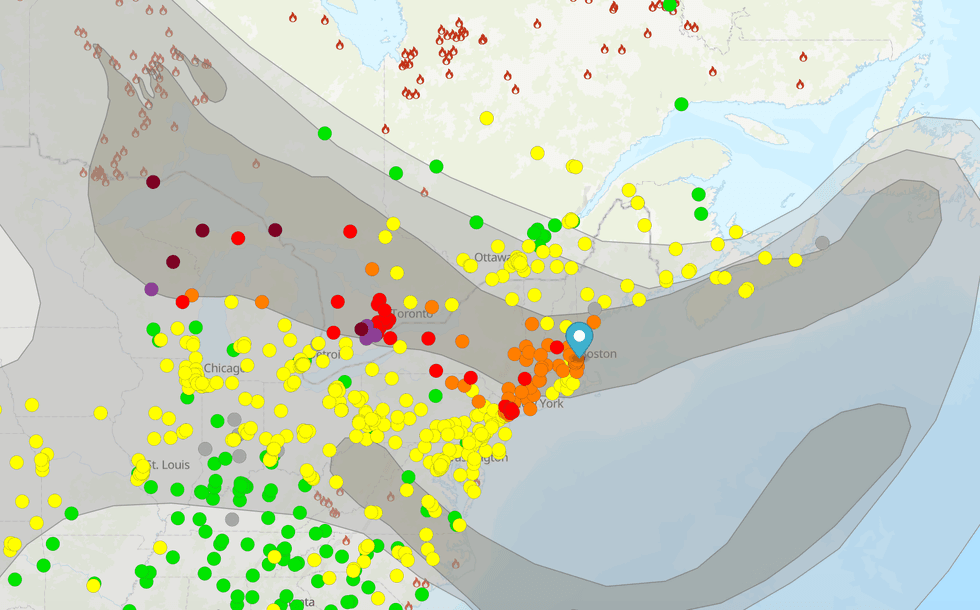
 AirNow.gov
A high-pressure area over the central U.S. and a low-pressure area over Eastern Canada are acting as a funnel, pulling bad air east across the Great Lakes region and into the populous Acela Corridor. Conditions are worst closest to the fires: Around 8 a.m. on Wednesday morning, Duluth, Minnesota had a “hazardous” air quality rating of 785 out of 800. By the afternoon, Toronto had the worst air quality of any major city in the world, and drivers in northern Michigan have been advised to slow down and turn on their low-beam headlights because visibility has been so reduced by the smoke. The eastern-moving plume has also blanketed large portions of Upstate New York.
Degraded air quality reached the Boston and New York City areas on Tuesday night and is expected to linger through Thursday. The smoke reaches as far north as Maine, having dimmed the morning light in New Hampshire, and could spread as far south as Washington, D.C. over the next 24 hours.
Though the smoke is staying largely to the north over the middle part of the country, forecasts show it could dip into downtown Chicago on Thursday as well.
How bad will it get?
Wednesday and early Thursday will be the worst days for the eastern U.S., per the current outlook. A cold front should help push the worst of the smoke out of the region as we head into the weekend.
So far it appears that much of the smoke has remained high enough in the atmosphere that while you’ll be able to see and likely smell it, it might not cause extreme air quality problems on the ground. As of Wednesday afternoon, New York City was recording some of the worst air on the East Coast, with an air quality index of around 160 — bad enough to trigger an “unhealthy” alert for the general public and to rank fifth-worst among major cities worldwide. The rest of the region still mostly showed orange readings designed to alert sensitive groups such as older adults, people with respiratory conditions, and pregnant women, or more moderate yellow ratings.
Conditions could still change, though. Heat, pressure, and winds can drive smoke down to ground level, where it becomes a threat to public health. In fact, the Fox Forecast Center’s models indicate that particulate matter concentrations around the Great Lakes and Northeast could be on par with the 2023 East Coast smoke event, during which New York had the world’s worst air quality, although The New York Times reports that “even the most severe forecasts” this week should not approach that level.
The best thing to do is to continue monitoring your local air quality. If you want help navigating what those readings mean, my colleague Emily Pontecorvo has written a great explainer.
Why does smoke make the sky look orange?
For many on the East Coast, the orange skies are a flashback to the 2023 smoke event. While eerie and apocalyptic, the smoke also gives us an excuse to talk about Mie theory.
Air molecules are much smaller than the wavelength of light. When white light from the sun enters the atmosphere, nitrogen and oxygen scatter the short, higher-frequency blue light in multiple directions. This is known as Rayleigh scattering, and is also the answer to, “Why is the sky blue?” Under normal conditions, wherever you look in the sky, blue light is headed toward your eye.
Smoke particles, while small enough to enter our lungs when inhaled, are larger than air molecules — about the same size as light wavelengths. Because these particles are larger, they also scatter light more democratically, including the lower-frequency, longer reds and oranges. This is called Mie scattering. When sunlight passes through smoke, the reds, oranges, yellows, and blues are all mixed together as they reach our eyes, appearing as a hazy gray or white.
You might expect thicker smoke to result in a darker gray, then. But smoke also contains organic compounds from burned plants called brown carbon, plus soot, both of which absorb visible light. Brown carbon, in particular, prefers light at the shorter end of the spectrum, absorbing about three-quarters of the total light at blue wavelengths in smoke plumes, compared to about half at red wavelengths. That means that when the smoke thickens, the blue light doesn’t reach our eyes nearly as well, and the sky takes on an orange appearance.
What can I do to protect myself?
One of the dangers of the current smoke event is that it coincides with high temperatures across the Central U.S. and New England. Both conditions together — high heat and smoke — can lead to some confusion over how to respond.
The best strategy is to keep your windows closed. But while it might feel safe side, wildfire smoke can still degrade indoor air quality. “If you have a fresh air intake on your air conditioning system, I would shut that off so that you’re recirculating just your purified air inside your house,” Allen, the firefighter, told me.
You can also install activated carbon exterior filters on attic and crawl space vents and run a purifier with a HEPA filter. (If you bought an air purifier during the last smoke event, consider this your reminder to replace your filter.) “Then I would avoid going outside or exercising outside if there’s smoke in the air,” Allen added. “When the particles are arriving to you from a great distance from the wildfire, they are the smaller particles that can get in your lungs. So not to create undue fear, but there’s definitely stuff in that air that you don’t want to breathe.”


 AirNow.gov