The bill wouldn’t eliminate environmental oversight altogether. Small-scale marine energy projects would still undergo basic environmental screenings as a part of FERC licensing, and would still require state and local permits, which can trigger their own environmental reviews. They’d also remain subject to the Endangered Species Act and the Clean Water Act — though the bill would expedite reviews under both of those laws, too. On the whole, the reforms are intended to give developers and investors alike a quicker, more predictable timeline.
“Taking a 1-megawatt marine energy project and trying to license it like it’s a 1,000-megawatt conventional dam just wasn’t working. It was apples to oranges,” Matthew Allen, senior director of legislative affairs at the National Hydropower Association, told me. “Recognizing that it deserves its own process could be a tremendous market signal for the technology.”
After all, this tech certainly doesn’t look like large-scale hydropower, where colossal dams unleash thousands of tons of water per second that rush through electricity-generating turbines to the river below. Such gargantuan infrastructure projects typically require favorable geography — think big rivers running through steep, mountainous terrain, where a dam can create a sharp drop in elevation. And with most of the best sites in the U.S. already developed, the country is unlikely to build many new greenfield hydro projects anytime soon.
But less-developed marine energy technologies have barely scratched the surface of their potential. Some look like large buoys, bobbing with the ocean swells and converting that motion into electricity. Others use turbines anchored to the seafloor or riverbed, spinning as tides ebb and flow or river currents rush past. While these devices generate essentially zero power for the grid today, in theory the resource is enormous: The National Renewable Energy Laboratory estimates that wave, tidal, and river-current projects have the technical potential to generate a staggering 2,300 terawatt-hours of electricity annually — more than half of the country’s total electricity generation last year. Wave energy alone accounts for about 60% of that number.
Of course, technical potential is a long way from practical reality. Economic constraints, environmental regulations, competing water uses, and public acceptance could limit uptake of these technologies. NREL suggests that we would be lucky to eventually tap even 10% of marine energy’s potential. Meanwhile, most of the tech remains in the pilot or demonstration stage in the U.S. — which is exactly why expediting permitting for small-scale projects stands to have significant impact.
“Marine energy is so new and still so novel that a 5-megawatt device, it doesn’t even exist right now,” Jennifer Garson, former director of the Water Power Technologies Office during the Biden administration, told me. “So you’re still talking about a good amount of headroom for being able to deploy smaller-scale marine energy devices in rivers and nearshore.”
Early deployments have largely served remote or island communities. In the 70-person Alaska Native village of Igiugig, for example, Ocean Renewable Power Company installed two 35-kilowatt turbine systems on a local riverbed, designed to supply nearly half the village’s power and thus reduce reliance on expensive diesel generators. While the project’s pilot license expires in three years, the permitting bill could offer a pathway to continued power generation.
The lack of a commercial licensing pathway has already led to the demise of one promising project, National Hydropower Association senior program manager Kelly Rogers told me. Verdant Power’s tidal energy pilot in New York City’s East River — the first project of its type to receive a license in the U.S. — officially shuttered in 2021 when said pilot license expired. By then, its turbines had delivered over 312 megawatt-hours of total electricity to the grid, harnessing the tides as they flowed in and out of the saltwater channel.
Other companies in this space include wave energy startups Oscilla Power and CalWave, which make surface-floating and submerged wave energy converters, respectively, with the goal of selling to utility customers and remote communities alike. C-Power, another early-stage wave energy company, is focused on powering off-grid equipment like ocean sensors. And while all have received at least some venture backing, a significant portion of their funding comes from Department of Energy grants.
In 2022, all three received DOE funding to trial their tech at PacWave, an Oregon-based facility that’s the first grid-connected wave energy test site in the continental U.S. Backed by the DOE, the facility secured all its necessary state and federal approvals in advance so that companies working there could largely bypass the permitting process and get their tech straight into the water. But getting there, Garson told me, involved an arduous 15 years of negotiations among the DOE, the Bureau of Ocean Energy Management, and state and local authorities before the facility could open for testing this August.
The permitting bill can only do so much to accelerate a permitting process like this, Garson explained. Even with a faster FERC licensing process, all projects in federal waters — generally those more than 3 nautical miles from shore — will still need a separate lease from BOEM, a complex process that the bill’s new permitting pathway wouldn’t replace. “One of the complexities of anything that you do with water is you just have so many split jurisdictional challenges and questions,” she told me.
It’s also telling that as of yet, there are no wave energy devices in PacWave’s waters, as the Trump administration’s federal funding freeze has scrambled the plans of some of the marine energy developers who’d originally intended to test there. Oregon startup AquaHarmonics, for example, was on track to deploy its wave energy converter at PacWave but had to shut down last year after the Trump administration withheld its previously allocated grant money.
“A lot of the device deployments, particularly in the United States, have been contingent on or reliant on federal funding,” Garson told me. “You’re dealing with still such early-stage R&D that it really points to a necessity for the federal government to be in this space”
But while the federal budget for emerging marine energy technologies has generally grown year over year, Garson said relatively little of that money is actually reaching developers. When she was still at the DOE, for example, the Water Power Technologies Office launched a funding solicitation offering up to $112.5 million in total for wave energy companies to test their devices at sea, including at PacWave. But while the DOE was supposed to announce the winners last year, Garson said it has yet to do so — and it’s disbursed no funding, either.
“That’s a long time for a lot of these companies to sit and wait for any funding to even be available,” she told me. CalWave, at least, still plans to hook its system up at PacWave, as the startup’s CEO, Marcus Lehmann, told me the company is “now in the construction phase of installing the first grid-connected system” and that it plans to launch at PacWave sometime in 2027 or 2028.
He sees the permitting bill as “really critical” in helping early-stage projects “get online faster, and just to prove it out on a community level or a microgrid level” before scaling up to larger installations and device arrays that would likely exceed the 5-megawatt threshold.
“Regulatory certainty, particularly when you’re dealing with capital-tight startups — great. Anything that makes their lives easier, I am all for,” Garson told me, calling the existing permitting structure for marine energy “byzantine.” But she doesn’t think that if the bill passes we’ll suddenly see a slew of wave, tidal, and river-current projects coming online. “You’re still talking about relatively small outputs of power until we reach more [technological] maturity.”
But it could certainly be a first step toward recognizing the potential of water power technologies beyond conventional hydropower — and giving them a place in the broader clean energy conversation. “This is a meaningful amount of power to a lot of people. We just tend to get so lost in the gigawatt conversation,” Garson told me.
And while developers do measure these projects in kilowatts and megawatts for now, one day they too could help move the needle at the gigawatt level. As Garson put it, “If we can figure out how to unlock the ocean — power for everybody, everywhere.”







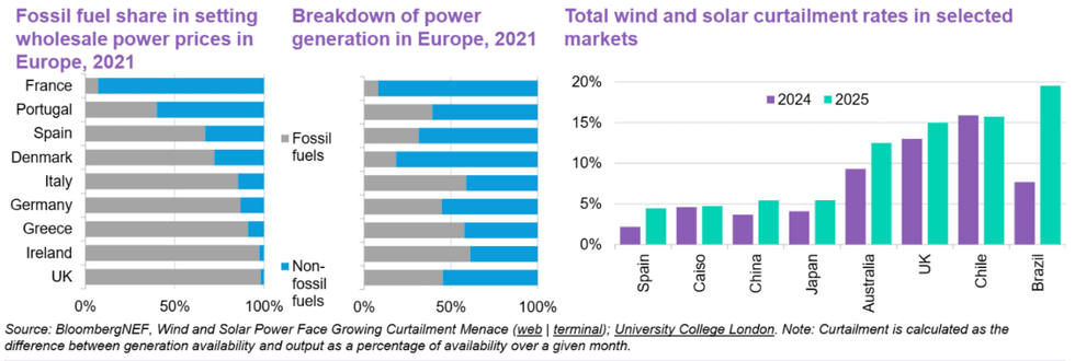 Curtailments are on the rise. BNEF