Americans living downwind of the Canadian fires can breathe a sigh of relief this week, knowing they’re likely safe from a repeat of last week’s
history-making smoke pollution event. But maybe don’t breathe too deeply — where there is fire, there is smoke, and there were still almost 450 active fires burning in Canada on Monday morning.
The good news is, the low-pressure front off the Atlantic Coast that
had been responsible for channeling smoke directly at New York City, Boston, and Washington, D.C., has weakened and broken up, meaning “the winds are fanning out in more directions, spreading the smoke across a wider area,” Bloomberg reports. The smoke from Canada now stretches as far east as Western Europe and Norway, but pollutant concentrations are low enough that most people aren’t in danger.
Still, if you’re planning on a big gardening project or a long run, earlier in the week will be better since some signs point to the potential for smoky air to return as we approach the weekend.
Here’s how things are stacking up across the country:
New York City and the Tri-State Region
The AQI hovered around 100 on Monday morning in New York City — just
a tick away from being considered unhealthy for sensitive groups. But the rain forecast for the city is expected to help clear up some of the lingering pollution via a process called “coagulation,” when water droplets essentially wash out pollutants from the air.
The bad news is, “in order to extensively clean out the air currently over our region, we would need a major rainstorm, such as a tropical storm or nor’easter,”
CBS News New York reports, noting that none are in our immediate forecast. Additionally, the pollution-clearing “bad weather” will likely be localized on Monday, meaning some areas will get flushed out better than others. There is even a chance that the stormy weather back East could actually fan the flames in Canada and eventually send more smoke back toward the States, AccuWeather’s meteorologists predicted.
Based on models at the time of publication, New York will remain under smoke through Tuesday morning, with the chance of some lingering smoke returning in low quantities on Wednesday morning. Much will depend on how much smoke is produced in the weeks — and possibly months — ahead, with some U.S. leaders turning their attention toward stopping the problem at the source.
Upstate New York
New York state remained under a cover of smoke going into Monday, although AQI warnings were mostly in a “moderate” under-100 range. Rain upstate though is expected to clear the air quality and hopefully help mitigate the local risk of more fires starting. Buffalo has gone 22 days without measurable rainfall, “a tie for the 10th longest stretch without measurable rainfall since rainfall records started back in 1874,”
ABC News’ local affiliate reports. If Canada gets the rain, too, it could help slow or put out some of the fires, leading to reduced smoke downwind in the States.
By mid-week, meteorologists forecast a new low-pressure system might form that could
pull smoke back down over western New York, though it’s doubtful it will be as bad as it was last week.
New England
New England was mostly spared the smoke during last week’s crisis due to the low-pressure zone that directed bad air around it. Because that system has now broken up, New England joins the rest of the East Coast this week under a hazy sun.
In particular, the National Weather Service warns that there will be “degraded air quality” on Monday evening due to the winds blowing smoke back into the area.
The Capital Region
The worst air quality in Washington, D.C., in any given year is usually on the Fourth of July ... due to firework smoke. That gives you some idea of how rare air this bad is in the DMV; last week, the U.S. Capital endured its worst smoke pollution on record.
Now for the good news: Clear air is expected to stick around this week as winds move the remaining pollutants north and east. There is no guarantee smoke won’t be back later this month or summer, but for now, it appears the Capital region can enjoy a breath of fresh(er) air.
The Midwest
Smoke is expected to billow back over the central United States later this week although the pollution will likely be too high in the atmosphere to impact ground-level air quality significantly. Still, the sun might look a little more red than usual:
The high-level smoky haze could last through at least Wednesday.
Everywhere else
The movement of smoke is famously tricky to predict, but there are
a few different models you can use to keep an eye on your area. Here are the models for the next day from the FireSmoke Canada website, which tracks PM2.5 smoke particles at ground level from wildfires across North America. Check the FireSmoke Canada website or NOAA models for the most up-to-date forecasts and keep in mind that, like forecasting the weather, these are not guarantees. Err on the side of caution and protect yourself.
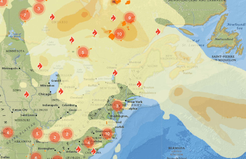
 The model for 7 p.m. on June 12. Darker colors indicate higher PM2.5 levels, the particles associated with wildfire smoke. The numbered circles refer to the number of regional wildfires.FireSmoke Canada
 The model for 7 a.m. on June 13. FireSmoke Canada
 The model for 1 p.m. on June 13. FireSmoke Canada


 The model for 7 p.m. on June 12. Darker colors indicate higher PM2.5 levels, the particles associated with wildfire smoke. The numbered circles refer to the number of regional wildfires.
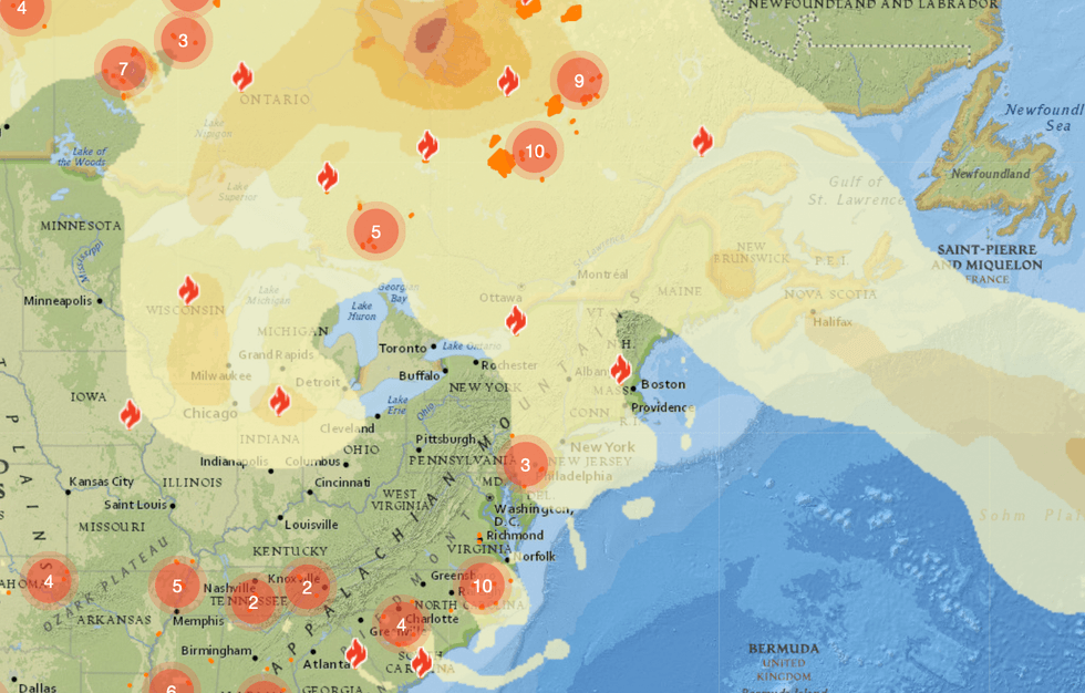 The model for 7 a.m. on June 13.
 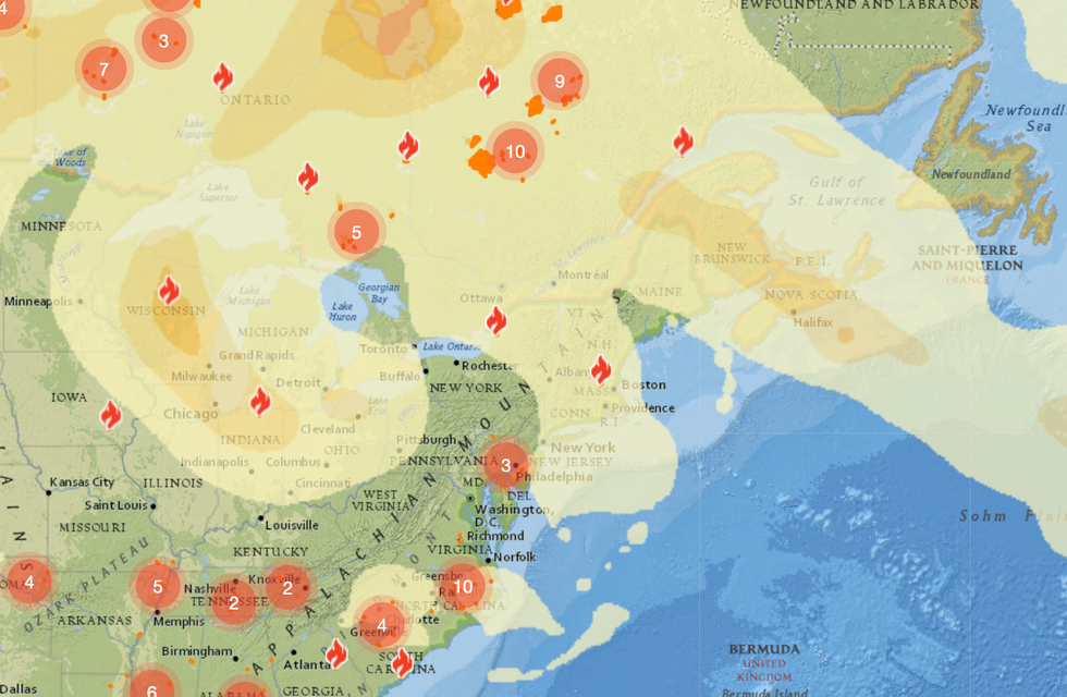 The model for 1 p.m. on June 13.


