Solving the energy side of the equation is a major hurdle for Jupiter, largely because of permitting delays and legal challenges.
In mid-September, the New Mexico Supreme Court lifted a stay it placed on consideration of the project’s state air permitting application. But on Wednesday, the Santa Fe New Mexican published emails between the New Mexico Environment Department and Project Jupiter staff detailing that independent emissions modeling showed pollution would be greater than predicted by the developers, after they had already requested permission to emit more CO2 than the state’s three largest cities combined. A final decision on the air permit was expected in November; the emails suggest the deadline may slip further. After the emails were reported, Oracle declared it would try to reduce emissions from the site by more than 30%.
At the same time, the New Mexico Justice Department is opposing the Federal Energy Regulatory Commission’s environmental assessment under the National Environmental Policy Act for a gas pipeline key to powering the project. The state’s attorneys assert the agency improperly failed to examine how the data center’s use of the pipeline would affect the environment. This week, a dozen GOP attorneys general representing states with large gas industries wrote FERC insisting they ignore the state’s protests, arguing that a recent Supreme Court ruling – known colloquially as Seven County – meant the federal government doesn’t need to look at the data centers gas pipelines are feeding when the lines are reviewed. Oracle has declared a “force majeure” over the pipeline delay. Rumors have circulated that trucks may just bring gas in for operations; company representatives told the Dona Ana County Commission this week those claims were “misinformation.”
Amidst these delays and potential legal conflicts, I’ve sought to understand whether projects like these – large data centers racing to operate within the next year or two – would be affected by enactment of the Bipartisan American Affordability and Jobs Act of 2026, a major permitting reform deal negotiated in part by New Mexico’s senior senator, Energy and Natural Resources chairman Martin Heinrich.
In Washington D.C., this legislation is exciting many constituencies, including energy industry types, policy wonks, business-friendly climate advocates. At the same time, more conservation-minded environmental groups opposed to provisions benefiting the fossil fuel industry are leaning into an argument that the legislation would accelerate a new era of gas-dominant data center construction.
Last week, I wrote about the environmentalists’ argument. I also examined the parts of the bill unlocking a new transmission build-out and requiring data center ratepayer protection. If enacted, FERC would have to require utilities to charge data centers not only for the costs of new grid upgrades but the charges incurred for using the grid, too. As my colleague Robinson Meyer has written, by forcing AI infrastructure operators to pay for both embedded and incremental energy costs, the legislation would essentially mean data centers paying both to reduce rates and build new energy generation. We’re seeing in real time what happens when you don’t deal with the transmission connection system while building new grid upgrades: companies will often opt to just build their own private off-grid fossil fuel islands. In Texas, for example, we’re seeing transmission hook-up delays lead to companies just building their own gas plants instead. This is not to say companies won’t still go off the grid if this bill passes, but it’s a serious consequence of our dilapidated energy system worth considering.
So I decided to evaluate Project Jupiter as a test case. How might the permitting bill affect this project and other big data centers at a stage like it?
For starters, let's say what the permitting bill does not do. It wouldn’t change the Clean Air Act. Project Jupiter would be one of the largest data centers in the country if completed, as well as potentially one of the nation’s biggest CO2 emitters if permitted as proposed. Nothing in the bill would affect requirements that the project adhere to national air emissions standards, so it wouldn’t affect the New Mexico Environment Department’s pending decision around the project’s air permits.
Enacting BAAJA could potentially affect this sprawling data center project in extremely hypothetical ways. It would reduce legal risks associated with future interstate gas pipelines under development expected to potentially branch out to Project Jupiter, including the Desert Southwest Expansion pipeline. It’s easy to understand in the words of Robert Pattinson in Primetime how this looks: like an easier path to expanding gas generation in this area.
On renewables, the bipartisan permitting deal would codify new permitting certainty and timeline provisions that claim to make it easier for companies to pursue solar development on federal acreage managed by the Bureau of Land Management. Project Jupiter just concluded a request for proposals to procure two gigawatts of renewable energy including solar power to meet the developers’ pledge to achieve 100% carbon matching by 2031 and Thiagarajan previously told the commission they’ve examined potentially getting energy from solar projects nearby on BLM lands.
But all of this is too theoretical and the case for any individual early-stage energy project too. Not to mention that we have no idea how the Trump administration would implement this certainty language, even for Project Jupiter.
To me, if people want to earnestly understand how the bipartisan permitting bill might actually affect data centers, they need to fully consider how making it easier and more transparent to hook up to the existing electric grid could reduce how much on-site gas generation is used at AI data center operations.
Delays in state permitting for the off-grid fuel cell plant have led Project Jupiter’s developers to consider what turning to the power grid would look like. In early September during a Dona Ana County commission meeting, Oracle executive vice president Mahest Thiagarajan told the panel, “If we end up in a situation where the air permit is not actually approved, I do have to work with a grid provider. Whether it is actually part of the grid or they built the grid for me could be TBD.”
“It doesn’t need to be on the grid, but I need [a] source of power to help power the data center,” Thiagarajan said.
Commission chair Manuel Sanchez replied that the microgrid plans were established in their community benefit agreement but he supported proposals requiring data center developers paying for upgrades and directly paying to reduce electricity rates for nearby residents. “It’s actually provided a downward pressure on rates,” Sanchez said, referring directly to such a policy created by the Georgia Public Service Commission.
Thiagarajan agreed. “My current plan is to continue to work with NMED [the New Mexico Environment Division] and get the off-grid site. If for any reason we have to, because I don’t have the air permit and I have to build the site, I strongly believe it has to come with me bringing down pressure to the rates. Period. I don’t think that’s a question of, I’m not increasing the rates. I actually have to come in and say, I am lowering the rates here.”
If Congress enacted this permitting bill in the lame duck, would Project Jupiter ditch plans to be off grid? It’s challenging to prove or disprove such a hypothetical. Representatives for the project did not respond to requests for comment. But we know any attempts at grid hookups without greater ratepayer protections are only leading to more conflict locally; this week, when Project Jupiter tried proposing a hook up to the grid for emergency power, the county commission fumed. Right now, the plan is still to power Project Jupiter with the gas fuel cell generation on site.
As I concluded this research, I noticed Heinrich’s office has actually promoted news coverage about what his efforts to enact data center ratepayer protections would do to Project Jupiter.
In early August, as the Senate was leaving for a summer recess, his office republished a Santa Fe New Mexican article about legislation the senator authored – the GRID Savings Act – and its potential impact on Project Jupiter. The article claimed that if Project Jupiter was unable to get its air permit, they’d be able to get power a different way under his proposal. The local news outlet also quoted an email from Sanchez, the county commission chair, stating that Heinrich’s bill “could be an avenue for Project Jupiter to fulfill their requirements if the air permit is denied.” Sanchez did not respond to requests for comment.
So I asked Senator Heinrich’s office for comment about this republished article, as well as if his permitting deal would indeed help ensure Project Jupiter was completed and came online. To conclude this story, here is their full statement:
The Senator has been clear that building big things responsibly means putting communities first. As he stated in his interview with the Albuquerque Journal, Project Jupiter botched community engagement from the start.
BAAJA is about making sure we build the energy infrastructure we need while keeping costs down for families and small businesses in New Mexico and across the country. The legislation would help get new energy generation, primarily clean energy, on the grid. By getting the energy onto the grid, states like New Mexico, which has enacted the Energy Transition Act, can continue working to ensure the energy powering our grid is increasingly clean.
The Senator has fought to ensure that growing energy demand doesn’t come at the expense of New Mexicans’ electricity bills by requiring data centers to pay for all of their associated transmission costs, rather than those costs shifting onto ratepayers. Ultimately, the Senator strongly believes that any major development, including data centers, should come as a benefit to the communities that host them, not a burden — and that starts with meaningful community engagement and real benefits for New Mexicans.
To be clear, BAAJA is federal legislation focused on energy infrastructure and grid connectivity. It does not ‘permit’ data centers. State and local government approval is still required. The Senator's legislation addresses the federal energy infrastructure challenges associated with a grid that cannot keep up with demand; it does not circumvent the state and local processes that determine whether Project Jupiter moves forward.
Media representatives for Project Jupiter did not respond to requests for comment.








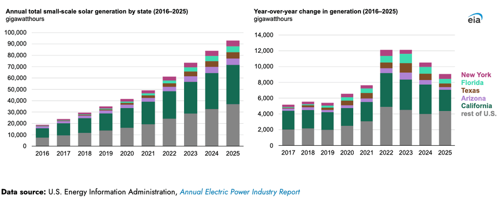 Solar capacity keeps growing. GoodPower