You’re out of free articles.
Log in
To continue reading, log in to your account.
Create a Free Account
To unlock more free articles, please create a free account.
Sign In or Create an Account.
By continuing, you agree to the Terms of Service and acknowledge our Privacy Policy
Welcome to Heatmap
Thank you for registering with Heatmap. Climate change is one of the greatest challenges of our lives, a force reshaping our economy, our politics, and our culture. We hope to be your trusted, friendly, and insightful guide to that transformation. Please enjoy your free articles. You can check your profile here .
subscribe to get Unlimited access
Offer for a Heatmap News Unlimited Access subscription; please note that your subscription will renew automatically unless you cancel prior to renewal. Cancellation takes effect at the end of your current billing period. We will let you know in advance of any price changes. Taxes may apply. Offer terms are subject to change.
Subscribe to get unlimited Access
Hey, you are out of free articles but you are only a few clicks away from full access. Subscribe below and take advantage of our introductory offer.
subscribe to get Unlimited access
Offer for a Heatmap News Unlimited Access subscription; please note that your subscription will renew automatically unless you cancel prior to renewal. Cancellation takes effect at the end of your current billing period. We will let you know in advance of any price changes. Taxes may apply. Offer terms are subject to change.
Create Your Account
Please Enter Your Password
Forgot your password?
Please enter the email address you use for your account so we can send you a link to reset your password:
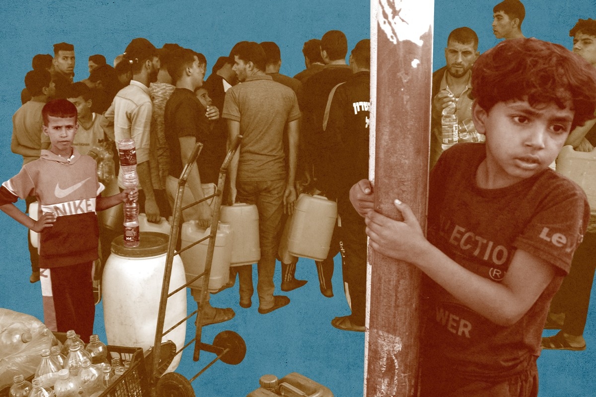
Home to two million people, the Gaza Strip sits squeezed between Israel and the Mediterranean Sea on a bit of land just twice the size of Washington, D.C. Gaza is the smaller part of Palestine’s two territories; you could walk the length of its southern border with Egypt in under three hours. But land is not the only thing that’s long been in short supply in Gaza. As the war between Israel and Hamas, the Palestinian militant group that rules the region, has made clear, Gaza is also increasingly bereft of water.
Over the course of the tragic war, water infrastructure has played an unprecedented role. In the aftermath of Hamas’s massacre and kidnapping of Israeli civilians on October 7, the Israeli government took measures to halt drinking water — as well as aid, food, and electricity — from entering the Strip. First, on October 9, Israel shut off the pipelines that usually send water into Gaza and halted deliveries by truck. And while it turned back on some of the pipelines on October 15, it didn’t restart the electricity or the fuel shipments that power Gaza’s desalination and wastewater treatment plants.
Yet these harsh measures in recent weeks belie a much longer-term problem, as a deeper dive into the region’s infrastructure reveals. Palestinians in Gaza have not had access to safe or ample drinking water for decades.
“The water crisis that Gaza is facing is a chronic crisis,” Dr. Shaddad Attili, the former Palestinian minister of water and head of the Palestinian Water Authority (PWA) from 2008 to 2014, told me. “But now water is being used as a weapon. If they don’t get killed by missiles, they will die from the contaminated water that they’re using.”
The Israeli Defense Forces, the water authority in the West Bank, and COGAT, the Israeli body responsible for the government activities in the Palestinian territories, all did not reply to requests for comment by the time of publication.
There are three natural water resources that run through Israel and Palestine: the Jordan River Basin on the eastern border; the Mountain Aquifer, which runs directly through the West Bank; and the Coastal Aquifer, on which Israel is upstream and Gaza is downstream. The majority of the water comes from these three sources, but since the region is a desert geography, water is generally in short supply.
Israel acquired control over all the water that runs through the Israeli and Palestinian territories in the Six-Day War in 1967 when it seized the Gaza Strip from Egypt, the West Bank from Jordan, and the Golan Heights in the north from Syria. In November of that year, Israel introduced a military order stating that Palestinians could not construct any new water infrastructure without first obtaining a permit from the Israeli army. Israel gave, and continues to give, these permits sparingly.
Today, the water discrepancy is striking. While there are eight times more Palestinians living in the West Bank than Israeli settlers, 70% of the water output is given to the settlements, where it is largely used for farming, according to an April 2023 report on the West Bank’s water deprivation by the Israeli humanitarian organization, B’Tselem.
During the Oslo Accords in the mid-1990s, the West Bank won some rights to run their own pumping stations in select parts of the territory. Today, they still need to earn permits from the Israeli military in order to build new pumping stations. Gaza used to pump their water from the Coastal Aquifer, but developments over the past 30 years have made that water inaccessible.
Prior to this war, the water situation in Gaza was already dire. The World Health Organization said that Gaza’s water supply was unable to meet the minimum requirement for daily per capita water consumption.
Gaza has some unregulated pumping stations that pull water up from the aquifer, but they’re not a major cause of the problem. The Coastal Aquifer extends from a town called Binyamina in Northern Israel to the Sinai Desert in Egypt. Just 2% of the total aquifer passes through Gaza. Through the late 1990s, it supplied drinkable tap water to most of Gaza’s residents. While it historically has provided 95% of their freshwater, it’s unusable now for a few reasons.
First, Gaza’s population growth rate is among the highest in the world, with almost half of the population under 18 years old in 2022. High population growth means the already scarce groundwater can no longer replenish fast enough to meet demand.
But there are deeper problems with the water’s quality. Seawater seeps into the aquifer since it’s so close to the coast and untreated wastewater has polluted the aquifer for decades to a point that it’s no longer safe to drink. In 2020, a study in the journal Water said that the quality of groundwater in the Coastal Aquifer had “deteriorated rapidly,” largely due to Israeli pumping.
“At least 95% of the freshwater (from the aquifer) is either inaccessible or not drinkable,” said Jordan Fischbach, director of planning and policy research at The Water Institute and author of a report on the public health impacts of Gaza’s water crisis in 2018.
As a result, the Coastal Aquifer — the primary source of Gaza’s water — is essentially out of commission. Residents of Gaza are now left with only about 20% of their needs filled.
But those sources have also proven to be unreliable.
The first are the pipelines, which were built with funding from international humanitarian aid. The pipelines run from Israel-controlled fresh aquifers and the water is paid for by the Palestinian National Authority (PA) in the West Bank. These are the pipelines that Israel stopped sending water from following Hamas’ attack on Israeli civilians.
But even in the best of times, the pipelines only supply around 10% of the water demand in Gaza. Attili from the Palestinian National Authority said that the water is combined with some of the unsafe brackish water in order to increase volume.
The second source of water are small-scale desalination plants, which turn seawater into potable water, but they rely on electricity to run.
Usually they provide another 10% of Gaza’s water, but when Israel halted the importation of fuel and shut down electricity transmission into Gaza, these plants stopped running too.
However, even when electricity and fuel are available, over one-third of plants are not monitored, maintained, or officially regulated. “A number of construction materials, fuel and other things you would need to build and power drinking and wastewater facilities are considered ‘dual use.’” said Fischbach, meaning they could also be used to build weapons. “These are types of materials that are restricted by both Egyptian and Israeli authorities.”
A 2021 study showed that 79% of desalination plants are unlicensed and 12% of water samples tested showed dangerous contamination levels.
“Desalination is necessary to get anything even close to drinking water quality and only a fraction of [desalination plants] are actually licensed and monitored” said Fischbach. “Many of them are producing water that we would still consider below drinking water quality.”
He added that most of them don’t run to their capacity anyways because they are so energy intensive and Gaza doesn’t have enough electricity.
Gaza also gets water from water trucks controlled by humanitarian aid or delivered by the Palestinian National Authority. This water passes directly through Israeli land, which means Israel was able to easily halt deliveries in the wake of the Hamas attacks.
In recent weeks, some residents of Gaza have resorted to drinking sea water or brackish water directly from the Coastal Aquifer. Not only are these not sources of freshwater, they are also further polluted by untreated sewage running through the region.
Israel’s decision to cut electricity to Gaza also meant that the wastewater treatment plants can’t run. Treated wastewater is used for showering and other sanitation uses. But when it’s not processed through a plant, wastewater runs into the aquifer and groundwater, further polluting what’s left of their drinking sources.
While the situation is worse due to the lack of electricity from the war, Gaza has never had ample wastewater treatment plants.
“For two decades now Palestinians have been prevented from building and maintaining the infrastructures that keep wastewater out of the aquifer,” says Sophia Stamatopoulou-Robbins, a cultural anthropologist and professor at Bard College. She is the author of Waste Siege: the Life and Infrastructure of Palestine.
In the West Bank, the aquifer is deep, carrying around 340 million cubic meters of water every year, so wastewater that has been somewhat treated can be further cleaned by soil and rock as it seeps through the aquifer. But Gaza’s aquifer is very shallow — its estimated to carry only about 55 million cubic meters per year —, and therefore cannot clean the water. Instead, it needs extensive infrastructure.
“In Gaza, you would need an incredibly high sophistication of technology to permit the wastewater to go safely into the ground,” says Stamatopoulou-Robbins. “Even the kind of concrete containers that would hold wastewater are not permitted to be maintained or built.”
In addition to the plants themselves, you would need piping to connect buildings to the wastewater treatment plants, she adds. “So all of the conveyance technology and infrastructure which is expensive anywhere in the world, all of that is subject to Israeli controls and tends to be prevented.”
As is the case with desalination plants, neither Israel nor Egypt allows the necessary materials into Gaza for building wastewater treatment plants because those materials are also considered dual-use materials.
Even as Israel turned the water and electricity back on, there are questions around how many of these desalination and wastewater treatment plants have been bombed and are no longer running.
As far as logistically turning off these resources, it’s fairly straightforward. “The ability to shut off electricity transmission is quite easy,” said Fischbach. “It’s just flipping a switch — the same way with a rolling blackout. Fuel imports are also easy. Nothing is going into Gaza. As far as drinking water lines, you can just not pump that water. So the logistics are easy.”
Several reports of hygiene related diseases spreading through cramped spaces are surfacing in recent days. Doctors in Gaza are saying that patients are showing signs of disease caused by overcrowding and poor sanitation. Children are suffering from diarrhea, lung infections, and rashes.
“The desalination plants are out of service because there’s no electricity, the sewage treatment plants are out of service because there is no electricity. And because our people now take refuge in shelters, there is a hygiene problem,” said Attili. “I have gone to so many conferences where we say water is a tool for cooperation, not conflict, and they all agree, but now the international community remains silent.”
Log in
To continue reading, log in to your account.
Create a Free Account
To unlock more free articles, please create a free account.
Paradise, California, is snatching up high-risk properties to create a defensive perimeter and prevent the town from burning again.
The 2018 Camp Fire was the deadliest wildfire in California’s history, wiping out 90% of the structures in the mountain town of Paradise and killing at least 85 people in a matter of hours. Investigations afterward found that Paradise’s town planners had ignored warnings of the fire risk to its residents and forgone common-sense preparations that would have saved lives. In the years since, the Camp Fire has consequently become a cautionary tale for similar communities in high-risk wildfire areas — places like Chinese Camp, a small historic landmark in the Sierra Nevada foothills that dramatically burned to the ground last week as part of the nearly 14,000-acre TCU September Lightning Complex.
More recently, Paradise has also become a model for how a town can rebuild wisely after a wildfire. At least some of that is due to the work of Dan Efseaff, the director of the Paradise Recreation and Park District, who has launched a program to identify and acquire some of the highest-risk, hardest-to-access properties in the Camp Fire burn scar. Though he has a limited total operating budget of around $5.5 million and relies heavily on the charity of local property owners (he’s currently in the process of applying for a $15 million grant with a $5 million match for the program) Efseaff has nevertheless managed to build the beginning of a defensible buffer of managed parkland around Paradise that could potentially buy the town time in the case of a future wildfire.
In order to better understand how communities can build back smarter after — or, ideally, before — a catastrophic fire, I spoke with Efseaff about his work in Paradise and how other communities might be able to replicate it. Our conversation has been lightly edited and condensed for clarity.
Do you live in Paradise? Were you there during the Camp Fire?
I actually live in Chico. We’ve lived here since the mid-‘90s, but I have a long connection to Paradise; I’ve worked for the district since 2017. I’m also a sea kayak instructor and during the Camp Fire, I was in South Carolina for a training. I was away from the phone until I got back at the end of the day and saw it blowing up with everything.
I have triplet daughters who were attending Butte College at the time, and they needed to be evacuated. There was a lot of uncertainty that day. But it gave me some perspective, because I couldn’t get back for two days. It gave me a chance to think, “Okay, what’s our response going to be?” Looking two days out, it was like: That would have been payroll, let’s get people together, and then let’s figure out what we’re going to do two weeks and two months from now.
It also got my mind thinking about what we would have done going backwards. If you’d had two weeks to prepare, you would have gotten your go-bag together, you’d have come up with your evacuation route — that type of thing. But when you run the movie backwards on what you would have done differently if you had two years or two decades, it would include prepping the landscape, making some safer community defensible space. That’s what got me started.
Was it your idea to buy up the high-risk properties in the burn scar?
I would say I adapted it. Everyone wants to say it was their idea, but I’ll tell you where it came from: Pre-fire, the thinking was that it would make sense for the town to have a perimeter trail from a recreation standpoint. But I was also trying to pitch it as a good idea from a fuel standpoint, so that if there was a wildfire, you could respond to it. Certainly, the idea took on a whole other dimension after the Camp Fire.
I’m a restoration ecologist, so I’ve done a lot of river floodplain work. There are a lot of analogies there. The trend has been to give nature a little bit more room: You’re not going to stop a flood, but you can minimize damage to human infrastructure. Putting levees too close to the river makes them more prone to failing and puts people at risk — but if you can set the levee back a little bit, it gives the flood waters room to go through. That’s why I thought we need a little bit of a buffer in Paradise and some protection around the community. We need a transition between an area that is going to burn, and that we can let burn, but not in a way that is catastrophic.
How hard has it been to find willing sellers? Do most people in the area want to rebuild — or need to because of their mortgages?
Ironically, the biggest challenge for us is finding adequate funding. A lot of the property we have so far has been donated to us. It’s probably upwards of — oh, let’s see, at least half a dozen properties have been donated, probably close to 200 acres at this point.
We are applying for some federal grants right now, and we’ll see how that goes. What’s evolved quite a bit on this in recent years, though, is that — because we’ve done some modeling — instead of thinking of the buffer as areas that are managed uniformly around the community, we’re much more strategic. These fire events are wind-driven, and there are only a couple of directions where the wind blows sufficiently long enough and powerful enough for the other conditions to fall into play. That’s not to say other events couldn’t happen, but we’re going after the most likely events that would cause catastrophic fires, and that would be from the Diablo winds, or north winds, that come through our area. That was what happened in the Camp Fire scenario, and another one our models caught what sure looked a lot like the [2024] Park Fire.
One thing that I want to make clear is that some people think, “Oh, this is a fire break. It’s devoid of vegetation.” No, what we’re talking about is a well-managed habitat. These are shaded fuel breaks. You maintain the big trees, you get rid of the ladder fuels, and you get rid of the dead wood that’s on the ground. We have good examples with our partners, like the Butte Fire Safe Council, on how this works, and it looks like it helped protect the community of Cohasset during the Park Fire. They did some work on some strips there, and the fire essentially dropped to the ground before it came to Paradise Lake. You didn’t have an aerial tanker dropping retardant, you didn’t have a $2-million-per-day fire crew out there doing work. It was modest work done early and in the right place that actually changed the behavior of the fire.
Tell me a little more about the modeling you’ve been doing.
We looked at fire pathways with a group called XyloPlan out of the Bay Area. The concept is that you simulate a series of ignitions with certain wind conditions, terrain, and vegetation. The model looked very much like a Camp Fire scenario; it followed the same pathway, going towards the community in a little gulch that channeled high winds. You need to interrupt that pathway — and that doesn’t necessarily mean creating an area devoid of vegetation, but if you have these areas where the fire behavior changes and drops down to the ground, then it slows the travel. I found this hard to believe, but in the modeling results, in a scenario like the Camp Fire, it could buy you up to eight hours. With modern California firefighting, you could empty out the community in a systematic way in that time. You could have a vigorous fire response. You could have aircraft potentially ready. It’s a game-changing situation, rather than the 30 minutes Paradise had when the Camp Fire started.
How does this work when you’re dealing with private property owners, though? How do you convince them to move or donate their land?
We’re a Park and Recreation District so we don’t have regulatory authority. We are just trying to run with a good idea with the properties that we have so far — those from willing donors mostly, but there have been a couple of sales. If we’re unable to get federal funding or state support, though, I ultimately think this idea will still have to be here — whether it’s five, 10, 15, or 50 years from now. We have to manage this area in a comprehensive way.
Private property rights are very important, and we don’t want to impinge on that. And yet, what a person does on their property has a huge impact on the 30,000 people who may be downwind of them. It’s an unusual situation: In a hurricane, if you have a hurricane-rated roof and your neighbor doesn’t, and theirs blows off, you feel sorry for your neighbor but it’s probably not going to harm your property much. In a wildfire, what your neighbor has done with the wood, or how they treat vegetation, has a significant impact on your home and whether your family is going to survive. It’s a fundamentally different kind of event than some of the other disasters we look at.
Do you have any advice for community leaders who might want to consider creating buffer zones or something similar to what you’re doing in Paradise?
Start today. You have to think about these things with some urgency, but they’re not something people think about until it happens. Paradise, for many decades, did not have a single escaped wildfire make it into the community. Then, overnight, the community is essentially wiped out. But in so many places, these events are foreseeable; we’re just not wired to think about them or prepare for them.
Buffers around communities make a lot of sense, even from a road network standpoint. Even from a trash pickup standpoint. You don’t think about this, but if your community is really strung out, making it a little more thoughtfully laid out also makes it more economically viable to provide services to people. Some things we look for now are long roads that don’t have any connections — that were one-way in and no way out. I don’t think [the traffic jams and deaths in] Paradise would have happened with what we know now, but I kind of think [authorities] did know better beforehand. It just wasn’t economically viable at the time; they didn’t think it was a big deal, but they built the roads anyway. We can be doing a lot of things smarter.
A war of attrition is now turning in opponents’ favor.
A solar developer’s defeat in Massachusetts last week reveals just how much stronger project opponents are on the battlefield after the de facto repeal of the Inflation Reduction Act.
Last week, solar developer PureSky pulled five projects under development around the western Massachusetts town of Shutesbury. PureSky’s facilities had been in the works for years and would together represent what the developer has claimed would be one of the state’s largest solar projects thus far. In a statement, the company laid blame on “broader policy and regulatory headwinds,” including the state’s existing renewables incentives not keeping pace with rising costs and “federal policy updates,” which PureSky said were “making it harder to finance projects like those proposed near Shutesbury.”
But tucked in its press release was an admission from the company’s vice president of development Derek Moretz: this was also about the town, which had enacted a bylaw significantly restricting solar development that the company was until recently fighting vigorously in court.
“There are very few areas in the Commonwealth that are feasible to reach its clean energy goals,” Moretz stated. “We respect the Town’s conservation go als, but it is clear that systemic reforms are needed for Massachusetts to source its own energy.”
This stems from a story that probably sounds familiar: after proposing the projects, PureSky began reckoning with a burgeoning opposition campaign centered around nature conservation. Led by a fresh opposition group, Smart Solar Shutesbury, activists successfully pushed the town to drastically curtail development in 2023, pointing to the amount of forest acreage that would potentially be cleared in order to construct the projects. The town had previously not permitted facilities larger than 15 acres, but the fresh change went further, essentially banning battery storage and solar projects in most areas.
When this first happened, the state Attorney General’s office actually had PureSky’s back, challenging the legality of the bylaw that would block construction. And PureSky filed a lawsuit that was, until recently, ongoing with no signs of stopping. But last week, shortly after the Treasury Department unveiled its rules for implementing Trump’s new tax and spending law, which basically repealed the Inflation Reduction Act, PureSky settled with the town and dropped the lawsuit – and the projects went away along with the court fight.
What does this tell us? Well, things out in the country must be getting quite bleak for solar developers in areas with strident and locked-in opposition that could be costly to fight. Where before project developers might have been able to stomach the struggle, money talks – and the dollars are starting to tell executives to lay down their arms.
The picture gets worse on the macro level: On Monday, the Solar Energy Industries Association released a report declaring that federal policy changes brought about by phasing out federal tax incentives would put the U.S. at risk of losing upwards of 55 gigawatts of solar project development by 2030, representing a loss of more than 20 percent of the project pipeline.
But the trade group said most of that total – 44 gigawatts – was linked specifically to the Trump administration’s decision to halt federal permitting for renewable energy facilities, a decision that may impact generation out west but has little-to-know bearing on most large solar projects because those are almost always on private land.
Heatmap Pro can tell us how much is at stake here. To give you a sense of perspective, across the U.S., over 81 gigawatts worth of renewable energy projects are being contested right now, with non-Western states – the Northeast, South and Midwest – making up almost 60% of that potential capacity.
If historical trends hold, you’d expect a staggering 49% of those projects to be canceled. That would be on top of the totals SEIA suggests could be at risk from new Trump permitting policies.
I suspect the rate of cancellations in the face of project opposition will increase. And if this policy landscape is helping activists kill projects in blue states in desperate need of power, like Massachusetts, then the future may be more difficult to swallow than we can imagine at the moment.
And more on the week’s most important conflicts around renewables.
1. Wells County, Indiana – One of the nation’s most at-risk solar projects may now be prompting a full on moratorium.
2. Clark County, Ohio – Another Ohio county has significantly restricted renewable energy development, this time with big political implications.
3. Daviess County, Kentucky – NextEra’s having some problems getting past this county’s setbacks.
4. Columbia County, Georgia – Sometimes the wealthy will just say no to a solar farm.
5. Ottawa County, Michigan – A proposed battery storage facility in the Mitten State looks like it is about to test the state’s new permitting primacy law.