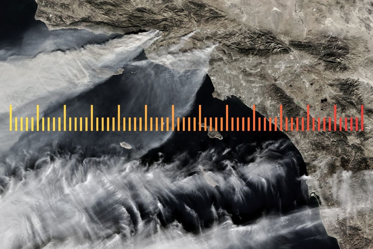
It’s significant, I think, that a mass smoke-out like this has now happened to the eastern U.S. for a second time. Second times matter. When exhaust from Canadian wildfires blanketed the Northeast and parts of the Midwest in June 2023, exposing more Americans to wildfire smoke than on any previous day in history, one could almost write it off as a freak occurrence. It was upsetting, sure, and reminiscent of California’s climate-addled amber skies. But didn’t wildfire smoke also descend on New England once in the 1780s? Even on a warmer planet, couldn’t this remain a once-in-a-century blip?
Twice in just over three years, though — that‘s more than a hiccup. That’s almost a trend. To get smoked out once may be regarded as a misfortune; for it to recur again, without any plan to respond, starts to look like carelessness. The federal government is doing roughly diddly squat about adaptation — President Trump can build a fan on the border and make Canada pay for it — but state and local governments across the eastern U.S. will now need to reckon with a new form of extreme weather. You grew up with snow days, but now we’ll have smoke days — and schools and sports leagues and concert venues will need rules about how to deal with them. When should games be canceled, tickets refunded? Is smoke more like a heat wave or a hurricane? Hotels and office buildings will need to review their ventilation policies and possibly upgrade their equipment; municipal emergency response plans will be revised and printed in triplicate.
All this will happen because the smoke has invaded a second time — and arguably a third, if you count last year’s minor episode — and that means it could come back again. For that reason, this event strikes me as a much bigger deal than what happened in 2023. The smoke is now a fact of life; institutions will need a policy about it. The tortious creep of litigation risk will enforce that outcome, even if no federal official enforces it.
So it goes. But to be clear, this new inconvenience is not what worries me most about today’s events. No, what frightens me instead is that today’s airborne toxic event is not something that was supposed to happen. Until a few years ago, we had not thought too hard about whether a major smoke exposure event like this could happen on the East Coast at all. It had not seemed possible.
For years, economists and climate scientists have simulated how global warming might affect the U.S. and global economies. They poured years of careful work into this modeling, and they simulated — with ever-increasing levels of statistical persnicketiness — what extreme heat and sea-level rise might do to agricultural yield, labor productivity, energy demand, heat mortality, and real estate values, among other potential sources of damage. This work was useful; it improved our practical understanding of coastal flooding, to name one example. It also helped calibrate U.S. regulatory policy, even if it never achieved the crowning heights of helping to set a national carbon tax.
Yet these careful models almost never accounted for mass smoke exposure days. Indeed, the kind of thing that happened this week — when heavy haze blows down from Canada and exposes more than 100 million people to hazardous air — was not countenanced by the simulations at all. Only in recent years did economists begin to study events like these, and only because mass exposure events like 2023’s happened first.
We’ve long known that the tiny shreds of particulate matter in wildfire smoke dance across the body’s barriers and penetrate its deep places, etching their way into lung, heart, and brain tissue. Inflammation follows. What makes days like today unique is the scale: Tens of millions of Americans inhaling wildfire smoke at the same time. As we’ve started studying this phenomenon, it’s become clear that the mortality effects of days like today, the deaths elevated above what you’d otherwise expect, can persist for years. That becomes extraordinarily expensive for society.
How costly? “When monetized,” a group of Stanford and Princeton economists wrote in Nature last year, in the first major study on the topic, “the climate-driven smoke deaths result in economic damages that exceed existing estimates of climate-driven damages from all other causes combined in the U.S.A.”
You read that right: The cost of climate-worsened wildfire smoke alone is larger than what earlier studies said every other estimated cost of climate change would be, combined.
To summarize, wildfire smoke did not appear in our economic simulations of climate change. As recently as a few years ago, we did not really know that days like today — or June 7, 2023; or September 15, 2020; or September 9, 2020 — could occur. Then they happened. And happened again. And then we studied them and discovered that, in fact, they may be more expensive for the U.S. economy than we once thought climate change itself would be.
That worries me. Now we know these smoke-out days can happen; now they are fast becoming a rare but predictable feature of summer life. But until recently they were unimaginable. What other ignominies, what other tail risks and airborne surprises, are lurking in the uncontrolled experiment we’re running on the biosphere? What else — unforecast, unmodeled, unstudied, unthought of — lies ahead? After 10 years of covering the climate system, I am not someone who lies sleepless fretting about atmospheric CO2. But I do wonder what else we don’t know enough about to ask.


 Feel the Burnham. Carl Court/Getty Images


