You’re out of free articles.
Log in
To continue reading, log in to your account.
Create a Free Account
To unlock more free articles, please create a free account.
Sign In or Create an Account.
By continuing, you agree to the Terms of Service and acknowledge our Privacy Policy
Welcome to Heatmap
Thank you for registering with Heatmap. Climate change is one of the greatest challenges of our lives, a force reshaping our economy, our politics, and our culture. We hope to be your trusted, friendly, and insightful guide to that transformation. Please enjoy your free articles. You can check your profile here .
subscribe to get Unlimited access
Offer for a Heatmap News Unlimited Access subscription; please note that your subscription will renew automatically unless you cancel prior to renewal. Cancellation takes effect at the end of your current billing period. We will let you know in advance of any price changes. Taxes may apply. Offer terms are subject to change.
Subscribe to get unlimited Access
Hey, you are out of free articles but you are only a few clicks away from full access. Subscribe below and take advantage of our introductory offer.
subscribe to get Unlimited access
Offer for a Heatmap News Unlimited Access subscription; please note that your subscription will renew automatically unless you cancel prior to renewal. Cancellation takes effect at the end of your current billing period. We will let you know in advance of any price changes. Taxes may apply. Offer terms are subject to change.
Create Your Account
Please Enter Your Password
Forgot your password?
Please enter the email address you use for your account so we can send you a link to reset your password:
With the ongoing disaster approaching its second week, here’s where things stand.

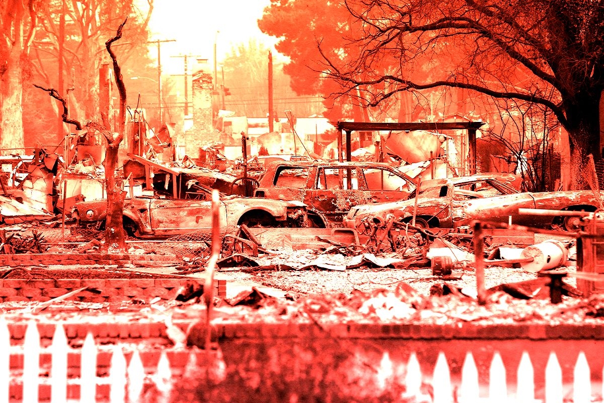
A week ago, forecasters in Southern California warned residents of Los Angeles that conditions would be dry, windy, and conducive to wildfires. How bad things have gotten, though, has taken everyone by surprise. As of Monday morning, almost 40,000 acres of Los Angeles County have burned in six separate fires, the biggest of which, Palisades and Eaton, have yet to be fully contained. The latest red flag warning, indicating fire weather, won’t expire until Wednesday.
Many have questions about how the second-biggest city in the country is facing such unbelievable devastation (some of these questions, perhaps, being more politically motivated than others). Below, we’ve tried to collect as many answers as possible — including a bit of good news about what lies ahead.
A second Santa Ana wind event is due to set in Monday afternoon. “We’re expecting moderate Santa Ana winds over the next few days, generally in the 20 to 30 [mile per hour] range, gusting to 50, across the mountains and through the canyons,” Eric Drewitz, a meteorologist with the Forest Service, told me on Sunday. Drewitz noted that the winds will be less severe than last week’s, when the fires flared up, but he also anticipates they’ll be “more easterly,” which could blow the fires into new areas. A new red flag warning has been issued through Wednesday, signaling increased fire potential due to low humidity and high winds for several days yet.
If firefighters can prevent new flare-ups and hold back the fires through that wind event, they might be in good shape. By Friday of this week, “it looks like we could have some moderate onshore flow,” Drewitz said, when wet ocean air blows inland, which would help “build back the marine layer” and increase the relative humidity in the region, decreasing the chances of more fires. Information about the Santa Anas at that time is still uncertain — the models have been changing, and the wind is tricky to predict the strength of so far out — but an increase in humidity will at least offer some relief for the battered Ventura and Orange Counties.
The Palisades Fire, the biggest in L.A., ripped through the hilly and affluent area between Santa Monica and Malibu, including the Pacific Palisades neighborhood, the second-most expensive zip code in Los Angeles and home to many celebrities. Structures in Big Rock, a neighborhood in Malibu, have also burned. The fire has also encroached on the I-405 and the Getty Villa, and destroyed at least two homes in Mandeville Canyon, a neighborhood of multimillion-dollar homes. Students at nearby University of California, Los Angeles, were told on Friday to prepare for a possible evacuation.
The Eaton Fire, the second biggest blaze in the area, has killed 16 people in Altadena, a neighborhood near Pasadena, according to the Los Angeles Times, making it one of the deadliest fires in the modern history of California.
The 1,000-acre Kenneth fire is 100% contained but still burning near Calabasas and the gated community of Hidden Hills. The Hurst Fire has burned nearly 800 acres and is 89% contained and is still burning near Sylmar, the northernmost neighborhood in L.A. Though there are no evacuation notices for either the Kenneth or the Hurst fires, residents in the L.A. area should monitor the current conditions as the situation continues to be fluid and develop.
The 43-acre Sunset Fire, which triggered evacuations last week in Hollywood and Hollywood Hills, burned no homes and is 100% contained.
The Lidia Fire, which ignited in a remote area south of Acton, California, on Wednesday afternoon, burned 350 acres of brush and is 100% contained.
It can take years to determine the cause of a fire, and investigations typically don’t begin until after the fire is under control and the area is safe to reenter, Edward Nordskog, a retired fire investigator from the Los Angeles Sheriff’s Department, told Heatmap’s Emily Pontecorvo. He also noted, however, that urban fires are typically easier to pinpoint the cause of than wildland fires due to the availability of witnesses and surveillance footage.
The vast majority of wildfires, 85%, are caused by humans. So far, investigators have ruled out lightning — another common fire-starter — because there were no electrical storms in the area when the fires started. In the case of the Palisades Fire, there were no power lines in the area of the ignition, though investigators are now looking into an electrical transmission tower in Eaton Canyon as the possible cause of the deadly fire in Altadena. There have been rumors that arsonists started the fires, but investigators say that scenario is also pretty unlikely due to the spread of the fires and how remote the ignition areas are.
Officially, 24 people have died, but that tally is likely to rise. California Governor Gavin Newsom said Sunday that he expects “a lot more” deaths will be added to the total in the coming days as search efforts continue.
Incoming President Donald Trump slammed the response to the L.A. fires in a Truth Social post on Sunday morning: “This is one of the worst catastrophes in the history of our Country,” he wrote. “They just can’t put out the fires. What’s wrong with them?”
Though there is much blame going around — not all of it founded in reality — the challenges facing firefighters are immense. Last week, because of strong Santa Ana winds, fire crews could not drop suppressants like water or chemical retardant on the initial blazes. (In strong winds, water and retardant will blow away before they reach the flames on the ground.)
Fighting a fire in an urban or suburban area is also different from fighting one in a remote, wild area. In a true wildfire, crews don’t use much water; firefighters typically contain the blazes by creating breaks — areas cleared of vegetation that starve a fire of fuel and keep it from spreading. In an urban or suburban event, however, firefighters can’t simply hack through a neighborhood, and typically have to use water to fight structure fires. Their priority also shifts from stopping the fire to evacuating and saving people, which means putting out the fire itself has to wait.
What’s more, the L.A. area faced dangerous fire weather going into last week — with wind gusts up to 100 miles per hour and dry air — and the persistence of the Santa Ana winds during firefighting operations through the weekend made it extremely difficult for emergency managers to gain a foothold.
Trump and others have criticized Los Angeles for being unprepared for the fires, given reports that some fire hydrants ran dry or had low pressure during operations in Pacific Palisades. According to the Los Angeles Department of Water and Power, about 20% of hydrants were affected, mostly at higher elevations.
The problem isn’t a lack of preparation, however. It’s that the L.A. wildfires are so large and widespread, the county’s preparations were quickly overwhelmed. “We’re fighting a wildfire with urban water systems, and that is really challenging,” Los Angeles Department of Water and Power CEO Janisse Quiñones said in a news conference last week. When houses burn down, water mains can break open. Civilians also put a strain on the system when they use hoses or sprinkler systems to try to protect their homes.
On Sunday, Judy Chu, the Democratic lawmaker representing Altadena, confirmed that fire officials had told her there was enough water to continue the battle in the days ahead. “I believe that we're in a good place right now,” she told reporters. Newsom, meanwhile, has responded to criticism over the water failure by ordering an investigation into the weak or dry hydrants.
So-called “super soaker” planes have had no problem with water access; they’re scooping directly from the ocean.
Yes. Although aerial support was grounded in the early stages of the wildfires due to severe Santa Ana winds, flights resumed during lulls in the storms last week.
There is a misconception, though, that water and retardant drops “put out” fires; they don’t. Instead, aerial support suppresses a fire so crews can get in close and use traditional methods, like cutting a fire break or spraying water. “All that up in the air, all that’s doing is allowing the firefighters [on the ground] a chance to get in,” Bobbie Scopa, a veteran firefighter and author of the memoir Both Sides of the Fire Line, told me last week.
With winds expected to pick up early this week, aerial firefighting operations may be grounded again. “If you have erratic, unpredictable winds to where you’ve got a gust spread of like 20 to 30 knots,” i.e. 23 to 35 miles per hour, “that becomes dangerous,” Dan Reese, a veteran firefighter and the founder and president of the International Wildfire Consulting Group, told me on Friday.
Because of the direction of the Santa Ana winds, wildfire smoke should mostly blow out to sea. But as winds shift, unhealthy air can blow into populated areas, affecting the health of residents.
Wildfire smoke is unhealthy, period, but urban and suburban smoke like that from the L.A. fires can be particularly detrimental. It’s not just trees and brush immolating in an urban fire, it’s also cars, and batteries, and gas tanks, and plastics, and insulation, and other nasty, chemical-filled things catching fire and sending fumes into the air. PM2.5, the inhalable particulates from wildfire smoke, contributes to thousands of excess deaths annually in the U.S.
You can read Heatmap’s guide to staying safe during extreme smoke events here.
“The bad news is, I’m not seeing any rain chances,” Drewitz, the Forest Service meteorologist, told me on Sunday. Though the marine layer will bring wetter air to the Los Angeles area on Friday, his models showed it’ll be unlikely to form precipitation.
Though some forecasters have signaled potential rain at the end of next week, the general consensus is that the odds for that are low, and that any rain there may be will be too light or short-lived to contribute meaningfully to extinguishing the fires.
The chaparral shrublands around Los Angeles are supposed to burn every 30 to 130 years. “There are high concentrations of terpenes — very flammable oils — in that vegetation; it’s made to burn,” Scopa, the veteran firefighter, told me.
What isn’t normal, though, is the amount of rain Los Angeles got ahead of this past spring — 52.46 inches in the preceding two years, the wettest period in the city’s history since the late 1800s — which was followed by a blisteringly hot summer and a delayed start to this year’s rainy season. Since October, parts of Southern California have received just 10% of their normal rainfall
This “weather whiplash” is caused by a warmer atmosphere, which means that plants will grow explosively due to the influx of rain and then dry out when the drought returns, leaving lots of dry fuels ready and waiting for a spark. “This is really, I would argue, a signature of climate change that is going to be experienced almost everywhere people actually live on Earth,” Daniel Swain, a climate scientist at the University of California, Los Angeles, who authored a new study on the pattern, told The Washington Post.
We know less about how climate change may affect the Santa Anas, though experts have some theories.
At least 12,000 structures have burned so far in the fires, which is already exacerbating the strain on the Los Angeles housing market — one of the country’s tightest even before the fires — as thousands of displaced people look for new places to live. “Dozens and dozens of people are going after the same properties,” one real estate agent told the Los Angeles Times. The city has reminded businesses that price gouging — including raising rental prices more than 10% — during an emergency is against the law.
Los Angeles had a shortage of about 370,000 homes before the fires, and between 2021 and 2023, the county added fewer than 30,000 new units per year. Recovery grants and federal aid can lag, and it often takes more than two years for even the first Housing and Urban Development Disaster Recovery Grants’ expenditures to go out.
My colleague Matthew Zeitlin wrote for Heatmap that the economic impact of the Los Angeles fire is already much higher than that of other fires, such as the 2018 Camp fire, partly because of the value of the Pacific Palisades real estate.
The wildfires may “deal a devastating blow to [California’s] fragile home insurance market,” Heatmap’s Matthew Zeitlin wrote last week. In recent years, home insurers have left California or declined to write new policies, at least partially due to the increased risk of wildfires in the state.
Depending on the extent of the damage from the fires, the coffers of California’s FAIR Plan — which insures homeowners who can’t get insurance otherwise, including many in Pacific Palisades and Altadena — could empty, causing it to seek money from insurers, according to the state’s regulations. As Zeitlin writes, “This would mean that Californians who were able to buy private insurance — because they don’t live in a region of the state that insurers have abandoned — could be on the hook for massive wildfire losses.”
First and foremost, sign up for all relevant emergency alerts. Make sure to turn on the sound on your phone and keep it near you in case of a change in conditions. Pack a “go bag” with essentials and consider filling your gas tank now so that you can evacuate at a moment’s notice if needed. Read our guide on what to do if you get a pre-evacuation or an evacuation notice ahead of time so that you’re not scrambling for information if you get an alert.
The free Watch Duty app has become a go-to resource for people affected by the fires, including friends and family of Angelenos who may themselves be thousands of miles away. The app provides information on fire perimeters, evacuation notices, and power outages. Its employees pull information directly from emergency responders’ radio broadcasts and sometimes beat official sources to disseminating it. If you need an endorsement: Emergency responders rely on the app, too.
There are many scams in the wake of disasters as crooks look to take advantage of desperate people — and those who want to help them. To play it safe, you can use a hub like the one established by GoFundMe, which is actively vetting campaigns related to the L.A. fires. If you’re looking to volunteer your time, make a donation of clothing or food, or if you’re able to foster animals the fire has displaced, you can use this handy database from the Mutual Aid Network L.A. There are also many national organizations, such as the Red Cross, that you can connect with if you want to help.
The City of Los Angeles and the Los Angeles Fire Department have asked that do-gooders not bring donations directly to fire stations or shelters; such actions can interfere with emergency operations. Their website provides more information about how you can help — productively — on their website.

Log in
To continue reading, log in to your account.
Create a Free Account
To unlock more free articles, please create a free account.
The Earth Fire Alliance is aiming for a constellation of high-resolution sensors that can capture the whole globe every 20 minutes.
Wildfires burn tens of millions of acres worldwide every year, and they’re only becoming more destructive.
For the past few decades, satellites operated by the likes of NASA and NOAA have assisted fire crews in detecting and tracking wildfires in even the most remote, difficult-to-monitor landscapes. But helpful as they are, these systems can’t provide real-time, actionable insights. They typically can’t spot fires until they’ve grown to several acres, for instance. They also only provide an image of the same spot every 12 hours at best, and by the time the data reaches the ground, hours — sometimes days — may have passed.
But the nonprofit Earth Fire Alliance says it’s built a far more capable alternative. In the wee hours of Tuesday morning, it launched three minifridge-sized satellites into orbit, the first components of a purpose-built wildfire detection constellation of more than 50 satellites planned to be fully operational by the 2030s. Designed to detect much smaller blazes than existing systems, the network will give first responders earlier warning and more time to contain fires before they spread. FireSat will also provide the broader scientific community with new data on how and why smaller burns grow into destructive wildfires, helping to improve models of fire behavior amidst a changing climate.
“We’ll be able to see fires as small as five by five meters — that’s the size of a shipping container — and be able to see fires at a lower temperature than a lot of the other satellite systems do,” Karen O’Conner, a founding principal at Earth Fire Alliance, told me. Once the full constellation is in orbit, the goal is to use the satellite’s thermal imaging capabilities to provide updates on fires every 20 minutes. “When you think about how that compares with current systems, they might see two to three acres. They might be over the same region maybe once or twice a day,” O’Conner explained.
The initiative has raised $69 million from a coalition of philanthropic backers, including a $26 million grant from the Bezos Earth Fund, over $15 million from Google.org, and support from the Gordon and Betty Moore Foundation, as well as other donors. The alliance’s technical partner, Silicon Valley startup Muon Space, designed and built the satellites. The company validated its tech last March when it launched a prototype satellite into orbit that detected a small fire in Oregon that existing systems missed.
O’Connor told me the team has interviewed hundreds of firefighters, fire agency officials, and fire scientists since the project kicked off six years ago, so that they could design the system to meet their needs. Those features include ultra-high-resolution sensors and an unusually wide field of view — over 930 miles across. Each satellite can quickly scan vast swaths of land, imaging the entire globe in about 12 hours. With more satellites will come greater imaging frequency: The alliance aims to capture an image of any point on Earth at least once an hour by 2029, reaching every 20 minutes by the early 2030s.
Hourly imaging “gets us within operational decision making timeframes,” O’Connor told me. Many fire agencies already receive intelligence updates from weather monitoring stations on this cadence, meaning at this point FireSat data can fit directly into their existing workflows to inform decisions about if, where, and when to deploy crews.
FireSat also provides a much clearer, more detailed view of active fires than standard Earth observation satellites, whose imagery generally lacks the resolution needed to manage fires in real time. Its specialized sensor captures six distinct bands of light — one visible, one near infrared, and four thermal infrared bands — each revealing different characteristics of the fire and its progression.
Visible light provides a baseline view of the landscape, while near infrared wavelengths reveal how vegetation responds to a fire — a stronger near-infrared signal indicates healthy vegetation. Short-wave infrared allows satellites to see through smoke during active fires and identify the areas burning with the most intensity. Mid-wave infrared is FireSat’s most unique and valuable channel for fire detection. Unlike most systems which use a single mid-wave band, FireSat uses two. One is attenuated — essentially tuned down — to allow the sensor to measure extremely hot fires without its gradations becoming saturated. The other is not, allowing the satellite to pick up smaller, lower-intensity blazes.
Long-wave infrared helps detect cooler parts of a fire as well as the temperature of the surrounding landscape, including smoldering areas, burn scars, and changes in ground temperature. This helps researchers better distinguish fire signatures and understand their impacts on smoke and air quality.
The three newly launched satellites will now undergo about three months of testing and calibration before they begin feeding data directly to FireSat’s early adopters, which include Cal Fire in California as well as fire agencies in Colorado, Oregon, Texas, Africa, Australia and Portugal.
“We’ve started with the operational community because we think that they’re the ones that need to be using the data from the beginning,” O’Connor told me. But as FireSat’s data set grows and researchers build a more exact historical record of recent fires, the patterns that emerge should provide valuable scientific insights such as seasonal shifts in fire behavior, how fires spread across different environments, and their impacts on ecosystems, biodiversity, and emissions.
Fire modeling is already evolving quickly these days, as startups and research labs increasingly integrate AI into their wildfire simulation models and risk assessments. Examples include companies like Pano AI and Technosylva, as well as researchers at the USC Viterbi School of Engineering and the University of Buffalo. O’Connor told me she thinks FireSat’s data will help further improve these models. “By having a real-time, regularly updated fire path, they can actually go back in and train those tools again — like this is how the fire actually behaved — so that in the future those types of tools will be better for the operational decision makers.”
FireSat could also help reveal the true global scale of fire activity. Until recently, existing systems couldn’t reliably detect smaller conflagrations, so the historical record has mostly captured only the largest ones. A more complete picture of fire activity will improve carbon emissions accounting and inform better land management practices.
That said, it remains true that not every fire ought to be put out. Fire is a natural — and often essential — ecological cycle that helps landscapes like grasslands, chaparral, and forests stay healthy while clearing dead vegetation that would otherwise accumulate as fuel for more destructive wildfires. O’Connor expects FireSat to play a role here, as well, giving agencies a better way to monitor prescribed burns and naturally occurring fires alike to ensure they deliver their ecological benefits without getting out of hand.
Even so, there are limits to what better detection and more sophisticated modeling can achieve when it comes to reducing the toll of wildfires. As the deadly Los Angeles fires at the beginning of 2025 demonstrated, even blazes caught in their earliest stages can explode under a dangerous combination of high winds and drought — conditions that are becoming increasingly common with climate change. Furthermore, as people continue to build homes and infrastructure along the wildland-urban interface, there are limits to how much technology can protect developments in landscapes that are naturally adapted to burn.
Still, FireSat’s data stands to make a meaningful difference in our ability to respond to an increasingly fire-prone world, though those benefits won’t arrive overnight, of course. These first three satellites will offer an early glimpse of what FireSat can deliver at scale, with the real value of the constellation beginning to emerge by the end of the decade. “Four of the five biggest wildfire years were in the 2020s,” O’Connor told me. “We can’t afford to go any slower than that.”
On Trump’s mineral paradox, China’s Great Green Wall, and sodium-ion batteries
Current conditions: After devastating the U.S. island of Rota in the Northern Mariana Islands territory, Super Typhoon Bavi is barreling toward Taiwan with winds of up to 200 miles per hour • Rare tornadoes brought on by storms touched down in China’s Hubei province, leaving 11 dead • Temperatures in Madrid are hovering at around 100 degrees Fahrenheit all week as the Spanish capital roasts in Europe’s latest heat wave.
Exactly three weeks after President Donald Trump signed a formal memorandum to halt the bombing campaign against Iran that the United States and Israel embarked on nearly five months ago, the war is back on. After Washington accused Tehran of launching missiles at tankers passing through the Strait of Hormuz this week, Trump officially declared the resumption of combat. Speaking Wednesday morning at the NATO summit in Turkey, Trump called the Iranian regime “scum,” “sick people,” and “vicious, violent people” when asked about the peace pact during a press conference. “If they had a nuclear weapon, they’d use it,” Trump said. “So as far as I’m concerned, it’s over.” He spent the rest of the day posting more than a dozen videos and photos on his Truth Social account purportedly showing U.S. missile strikes in Iran. “This is in retribution for yesterday’s bombing of ships by Iran,” Trump wrote in one post. “If it happens again, it will get much worse!”
The market is certainly preparing for worse. The price of Murban crude, the benchmark for oil flowing out of the United Arab Emirates, spiked nearly 7% on Wednesday. The European benchmark, Brent crude, jumped more than 5%. The American pricing yardstick, West Texas Intermediate crude, rose by just over 1%. Last month, my colleague Matthew Zeitlin cautioned that, despite a ceasefire, it would take a while for the Strait of Hormuz to return to normal — and “even longer” for energy markets. Emphasis on that last part.
The world’s capacity to generate nuclear energy has increased by 2.2 gigawatts already this year as new Chinese reactors have come online at a rapid clip. By 2035, global nuclear capacity is on track to surge by 44% to 535 gigawatts, up from 372 gigawatts last year. That’s according to the latest forecast from the consultancy BloombergNEF. China, the unrivaled global leader in domestic reactor construction, is largely responsible for the projected spike. Today, the People’s Republic is the world’s No. 2 user of atomic energy behind the U.S., which has long operated the largest fleet of plants on the planet. But China is on pace to surpass the U.S. by 2030 with 102 gigawatts of nuclear capacity.
Among the more promising signs for the democratic world: The U.S. is now working with Japan and South Korea to commercialize new small modular reactor technologies. On Tuesday, at the margins of the NATO summit, U.S. Secretary of State Marco Rubio signed onto a memorandum with the foreign ministers of Japan and South Korea. The document “outlines opportunities for our three countries, which have complementary advantages in the civil nuclear field, to encourage mutually beneficial cooperation among their respective nuclear industries,” the State Department said in a statement.
Right after the presidential inauguration in January 2025, Matthew wrote a sharp piece identifying what he called the “paradox of Trump’s critical minerals crusade.” At issue was the fact that the new Trump administration planned to (and ultimately did) kill off policies designed to spur demand for domestically mined and processed minerals such as lithium, cobalt, and rare earths — even as he slashed barriers to increasing the supply of those metals. U.S. production of minerals is picking up as the White House brokers a growing list of deals to give the government equity stakes in mining firms in exchange for federal support for increasing output. Sure enough, the demand just isn’t there in the U.S. On Tuesday, the Financial Times reported that companies backed by the administration, including rare earths miner MP Materials, uranium producer Energy Fuels, and the rare earths refiner Phoenix Tailings are instead selling their goods to buyers in Asia. Japanese customers were “clamoring” for rare earth metals from Phoenix Tailings, CEO Nick Myers said. The materials the firm produces are ending up “primarily in Korea and Japan.”
That isn’t stopping Trump from reviving his calls for Washington to seize Greenland and its resources from Denmark, a founding NATO ally. Speaking at the conference in the Turkish capital of Ankara, the American president repeated his claim that the U.S. invasion of the world’s largest island following Copenhagen’s collapse to Nazi blitzkrieg in April 1940 should have qualified as a permanent conquest. “We took Greenland and then, stupidly, we gave it back,” Trump told reporters. “We shouldn’t have given it back to them. We’re the ones who need it. We need it for protection of the world, not just the United States.”
Sign up to receive Heatmap AM in your inbox every morning:

Not to be an old man about it, but I remember the Iraq War distinctly — the debates over the role of Baghdad’s oil and the calls from Congress for increased U.S. production with an eye toward energy independence. Here’s some data that will make you want to dismiss your humble millennial correspondent with an “ok boomer.” On Wednesday, the U.S. Energy Information Administration issued a definitive new analysis showing that U.S. petroleum exports hit a record high in April after Iran closed the Strait of Hormuz, forcing overseas buyers to find new sources of fuel. Exports increased to 13.6 million barrels per day, 15% more than the previous record set in March.
On the other end of the American energy spectrum, the nation’s largest provider of home battery and solar equipment just launched a distributed compute pilot program for artificial intelligence servers. Under the program, Sunrun will coordinate “the selling of inference capacity to enterprise compute buyers.” In other words, homeowners can earn money by hosting “compute nodes” — small servers —that then supply output to AI companies in much the same way Sunrun’s customers are paid by giving the virtual power plant operators access to solar panels and batteries. “Over nearly two decades, we have perfected our ability to operationalize, finance, and scale distributed assets,” Paul Dickson, Sunrun’s president and chief revenue officer, said in a press release. “We are now using our leadership position in distributed home energy and proven infrastructure to bring compute closer to the sources of energy and inference.”
Much like the United Nations effort to plant trees at the southern edge of the Sahara to keep the desert at bay, China is building a Great Green Wall. Since 1978, the country has planted 66 billion trees and plans another 34 billion by 2050 in a bid to slow the spread of the Gobi and Taklamakan deserts. A new study using satellite measurements of leafy areas found that the planted forests are greening much faster than wild ones. Younger trees grow faster. But even at similar ages, planted stands grew 4.6% faster, meaning they can absorb more carbon. The findings, according to Fertilizer Daily, “suggest global climate models should better distinguish forest types and age when accounting for carbon.”
Sodium-ion technology, as Heatmap’s Katie Brigham explained two years ago, promises cheaper, less combustible batteries than its dominant lithium-ion cousin. But it remains niche and underdeveloped. Perhaps not for long. On Wednesday, sodium battery startup Peak Energy announced plans for a factory in Sacramento capable of producing 4 gigawatt-hours of sodium battery systems annually. “America needs energy storage that is lower cost, more affordable, more reliable and purpose-built to meet the demand coming onto the grid,” Peak Energy CEO Landon Mossburg said in a statement. “This facility is proof that America can lead not only in inventing the technology, but in building it at scale.”
Generate Capital, CalSTRS, and the Rhodium Group have teamed up on a new Transition Acceleration Framework to measure and assess emissions impacts.
The most common way to judge whether a company or project is helping to tackle climate change is to measure emissions. Has the company reduced its carbon footprint? Will the project add fewer greenhouse gas emissions to the atmosphere than alternatives?
It’s a useful metric, but a limited one. One company might be doing more to advance the energy transition than another — by investing in an expensive, early-stage solution such as geothermal power, for example — but a comparison of their carbon footprints won’t necessarily show it. At the project level, a solar farm in Mississippi, where solar deployment has lagged, will do more to decarbonize the U.S. power grid than one of equal size in California, even though both projects emit zero carbon.
This presents a challenge for climate-minded investors like Jonah Goldman, the chief strategy officer of Generate Capital, who are trying to figure out where their dollars can make the biggest difference. To solve it, Goldman worked with colleagues at the California State Teachers Retirement System, which backs Generate’s investments, and a team at the Rhodium Group to develop a new way for investors to assess where to put their money.
“The question that most of the frameworks out there ask is, what are your carbon emissions today, and can your carbon emissions be lowered?” Goldman told me. “The Transition Acceleration Framework asks, how can you apply capital that has the best chance of getting to decarbonization over a reasonable time frame?
“It sounds like a similar question. It sounds like semantics. But it’s actually quite different,” he said.
At a high level, the Transition Acceleration Framework measures how much additional decarbonization a given investment can deliver beyond what would likely have occurred anyway. It can also be used to evaluate policy interventions and procurement decisions, such as where to get power for a data center. The Rhodium Group published a white paper describing the methodology on Thursday, as well as an accompanying report using it to evaluate options for powering data centers in the U.S.
The Transition Acceleration Framework has three components: transition potential, transition efficiency, and acceleration factor.
Transition potential is “the size of the emissions-reduction opportunity,” the white paper says — it measures the gap between the current trajectory for a given technology and its potential deployment in a deeply decarbonized world. Some of the solutions with the highest transition potential scores, per Rhodium’s analysis, include light duty electric vehicles and utility-scale solar.
Transition efficiency measures how effective a dollar spent on that technology can be at closing the gap, based on an estimate of the total capital expenditure required to realize the potential. There, more nascent solutions like low-carbon cement and geothermal power score higher than EVs and solar.
Rhodium combines these two complementary metrics into a single “technology factor,” a score on a scale from one to ten that can help identify the highest-leverage sectors to invest in. (The project is similar in spirit to Heatmap’s Decarbonize Your Life series, in which we tried to determine the highest-leverage actions a given individual could take to cut emissions. If you missed it, check it out.)
While the transition potential and efficiency metrics provide a high-level view into how transformative different types of investments can be, the third component of the framework — the acceleration factor — helps distinguish between specific projects.
This starts with an assessment of five “acceleration attributes” — cost reduction, capital availability, new markets, infrastructure and supply chains, and political economy — that represent different mechanisms by which a single investment can help move an entire technology category forward.
For cost reduction, for example, an investor might ask how likely it is that the project will reduce the cost of future deployments through learning by doing or economies of scale. If it’s a first-of-a-kind project, the answer is likely yes. For capital availability, they might look at whether the investment will de-risk the technology. Goldman praised Amazon’s early investment in Rivian delivery vans — not just because it took gas-powered Amazon vans off the road, but because it also spurred other automakers and major shippers such as Walmart and GM to follow suit.
“While the Amazon-Rivian deal wasn’t 100% responsible for it, it certainly was a huge signal to the market that there was safety in solving this last mile delivery problem,” he said.
The Rhodium report outlines a method investors can use to score and weight the various attributes and combine them with the technology factor score to reach a final “acceleration factor” score.
In an accompanying report, Rhodium researchers used the framework to compare a number of different options for powering data centers in the U.S. It’s a high-level assessment — i.e. it doesn’t consider project-specific acceleration attributes — but it provides a rough hierarchy of the arrangements that accelerate the energy transition the most against those that do the most harm. At the top of the list is a grid-connected data center that signs a power purchase agreement with a clean, firm generator, such as a nuclear or geothermal plant. At the bottom, with a negative score indicating it would actually hinder progress relative to a regular grid connection, is an off-grid data center powered entirely by natural gas.
Of course, hyperscalers prioritizing speed to power are unlikely to wait around for a nuclear plant to get built. But there are plenty of options between that and behind the meter gas. An off-grid data center that builds enough renewables and batteries for 95% of its electricity needs and relies on gas backup scores higher than a grid-connected project that buys spot market renewable energy certificates.
“Different data center power configurations can have a meaningfully different impact on the transition, even if you’re looking at things that might on the surface seem relatively similar,” Michael Delgado, a partner at Rhodium, told me.
For now, the Transition Acceleration Framework is just that — a framework. Rhodium is piloting it with Generate and CalSTRS, as well as some additional partners, conducting bespoke assessments or their portfolios and projects. The hope is that it could eventually inform not just individual investment decisions or portfolio analyses but regulations and policy packages.
“This is an open method that we’re trying to put out there and get feedback on from the investment and philanthropic and policy world,” Delgado said.