You’re out of free articles.
Log in
To continue reading, log in to your account.
Create a Free Account
To unlock more free articles, please create a free account.
Sign In or Create an Account.
By continuing, you agree to the Terms of Service and acknowledge our Privacy Policy
Welcome to Heatmap
Thank you for registering with Heatmap. Climate change is one of the greatest challenges of our lives, a force reshaping our economy, our politics, and our culture. We hope to be your trusted, friendly, and insightful guide to that transformation. Please enjoy your free articles. You can check your profile here .
subscribe to get Unlimited access
Offer for a Heatmap News Unlimited Access subscription; please note that your subscription will renew automatically unless you cancel prior to renewal. Cancellation takes effect at the end of your current billing period. We will let you know in advance of any price changes. Taxes may apply. Offer terms are subject to change.
Subscribe to get unlimited Access
Hey, you are out of free articles but you are only a few clicks away from full access. Subscribe below and take advantage of our introductory offer.
subscribe to get Unlimited access
Offer for a Heatmap News Unlimited Access subscription; please note that your subscription will renew automatically unless you cancel prior to renewal. Cancellation takes effect at the end of your current billing period. We will let you know in advance of any price changes. Taxes may apply. Offer terms are subject to change.
Create Your Account
Please Enter Your Password
Forgot your password?
Please enter the email address you use for your account so we can send you a link to reset your password:
With the ongoing disaster approaching its second week, here’s where things stand.
A week ago, forecasters in Southern California warned residents of Los Angeles that conditions would be dry, windy, and conducive to wildfires. How bad things have gotten, though, has taken everyone by surprise. As of Monday morning, almost 40,000 acres of Los Angeles County have burned in six separate fires, the biggest of which, Palisades and Eaton, have yet to be fully contained. The latest red flag warning, indicating fire weather, won’t expire until Wednesday.
Many have questions about how the second-biggest city in the country is facing such unbelievable devastation (some of these questions, perhaps, being more politically motivated than others). Below, we’ve tried to collect as many answers as possible — including a bit of good news about what lies ahead.
A second Santa Ana wind event is due to set in Monday afternoon. “We’re expecting moderate Santa Ana winds over the next few days, generally in the 20 to 30 [mile per hour] range, gusting to 50, across the mountains and through the canyons,” Eric Drewitz, a meteorologist with the Forest Service, told me on Sunday. Drewitz noted that the winds will be less severe than last week’s, when the fires flared up, but he also anticipates they’ll be “more easterly,” which could blow the fires into new areas. A new red flag warning has been issued through Wednesday, signaling increased fire potential due to low humidity and high winds for several days yet.
If firefighters can prevent new flare-ups and hold back the fires through that wind event, they might be in good shape. By Friday of this week, “it looks like we could have some moderate onshore flow,” Drewitz said, when wet ocean air blows inland, which would help “build back the marine layer” and increase the relative humidity in the region, decreasing the chances of more fires. Information about the Santa Anas at that time is still uncertain — the models have been changing, and the wind is tricky to predict the strength of so far out — but an increase in humidity will at least offer some relief for the battered Ventura and Orange Counties.
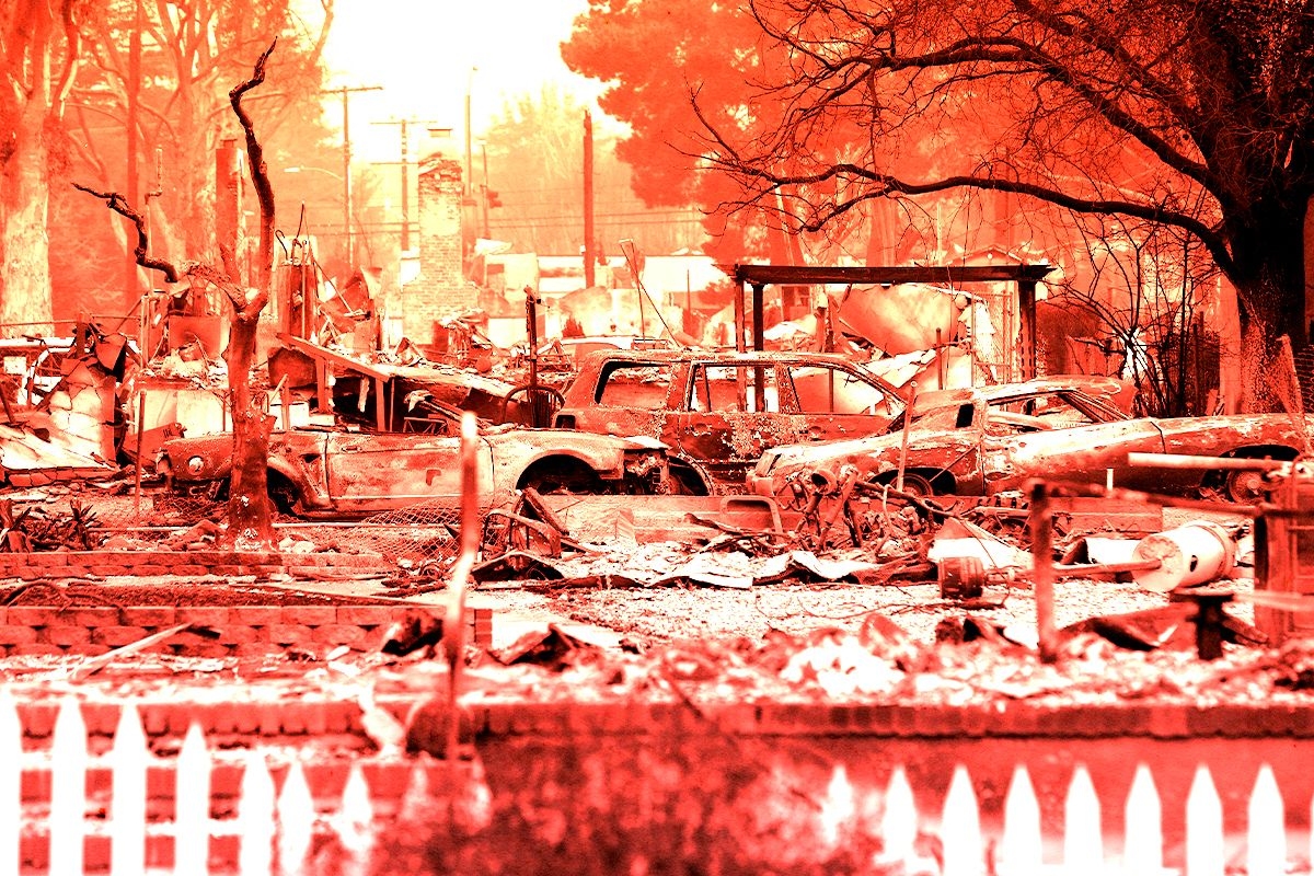
The Palisades Fire, the biggest in L.A., ripped through the hilly and affluent area between Santa Monica and Malibu, including the Pacific Palisades neighborhood, the second-most expensive zip code in Los Angeles and home to many celebrities. Structures in Big Rock, a neighborhood in Malibu, have also burned. The fire has also encroached on the I-405 and the Getty Villa, and destroyed at least two homes in Mandeville Canyon, a neighborhood of multimillion-dollar homes. Students at nearby University of California, Los Angeles, were told on Friday to prepare for a possible evacuation.
The Eaton Fire, the second biggest blaze in the area, has killed 16 people in Altadena, a neighborhood near Pasadena, according to the Los Angeles Times, making it one of the deadliest fires in the modern history of California.
The 1,000-acre Kenneth fire is 100% contained but still burning near Calabasas and the gated community of Hidden Hills. The Hurst Fire has burned nearly 800 acres and is 89% contained and is still burning near Sylmar, the northernmost neighborhood in L.A. Though there are no evacuation notices for either the Kenneth or the Hurst fires, residents in the L.A. area should monitor the current conditions as the situation continues to be fluid and develop.
The 43-acre Sunset Fire, which triggered evacuations last week in Hollywood and Hollywood Hills, burned no homes and is 100% contained.
The Lidia Fire, which ignited in a remote area south of Acton, California, on Wednesday afternoon, burned 350 acres of brush and is 100% contained.
It can take years to determine the cause of a fire, and investigations typically don’t begin until after the fire is under control and the area is safe to reenter, Edward Nordskog, a retired fire investigator from the Los Angeles Sheriff’s Department, told Heatmap’s Emily Pontecorvo. He also noted, however, that urban fires are typically easier to pinpoint the cause of than wildland fires due to the availability of witnesses and surveillance footage.
The vast majority of wildfires, 85%, are caused by humans. So far, investigators have ruled out lightning — another common fire-starter — because there were no electrical storms in the area when the fires started. In the case of the Palisades Fire, there were no power lines in the area of the ignition, though investigators are now looking into an electrical transmission tower in Eaton Canyon as the possible cause of the deadly fire in Altadena. There have been rumors that arsonists started the fires, but investigators say that scenario is also pretty unlikely due to the spread of the fires and how remote the ignition areas are.
Officially, 24 people have died, but that tally is likely to rise. California Governor Gavin Newsom said Sunday that he expects “a lot more” deaths will be added to the total in the coming days as search efforts continue.
Incoming President Donald Trump slammed the response to the L.A. fires in a Truth Social post on Sunday morning: “This is one of the worst catastrophes in the history of our Country,” he wrote. “They just can’t put out the fires. What’s wrong with them?”
Though there is much blame going around — not all of it founded in reality — the challenges facing firefighters are immense. Last week, because of strong Santa Ana winds, fire crews could not drop suppressants like water or chemical retardant on the initial blazes. (In strong winds, water and retardant will blow away before they reach the flames on the ground.)
Fighting a fire in an urban or suburban area is also different from fighting one in a remote, wild area. In a true wildfire, crews don’t use much water; firefighters typically contain the blazes by creating breaks — areas cleared of vegetation that starve a fire of fuel and keep it from spreading. In an urban or suburban event, however, firefighters can’t simply hack through a neighborhood, and typically have to use water to fight structure fires. Their priority also shifts from stopping the fire to evacuating and saving people, which means putting out the fire itself has to wait.
What’s more, the L.A. area faced dangerous fire weather going into last week — with wind gusts up to 100 miles per hour and dry air — and the persistence of the Santa Ana winds during firefighting operations through the weekend made it extremely difficult for emergency managers to gain a foothold.
Trump and others have criticized Los Angeles for being unprepared for the fires, given reports that some fire hydrants ran dry or had low pressure during operations in Pacific Palisades. According to the Los Angeles Department of Water and Power, about 20% of hydrants were affected, mostly at higher elevations.
The problem isn’t a lack of preparation, however. It’s that the L.A. wildfires are so large and widespread, the county’s preparations were quickly overwhelmed. “We’re fighting a wildfire with urban water systems, and that is really challenging,” Los Angeles Department of Water and Power CEO Janisse Quiñones said in a news conference last week. When houses burn down, water mains can break open. Civilians also put a strain on the system when they use hoses or sprinkler systems to try to protect their homes.
On Sunday, Judy Chu, the Democratic lawmaker representing Altadena, confirmed that fire officials had told her there was enough water to continue the battle in the days ahead. “I believe that we're in a good place right now,” she told reporters. Newsom, meanwhile, has responded to criticism over the water failure by ordering an investigation into the weak or dry hydrants.
So-called “super soaker” planes have had no problem with water access; they’re scooping directly from the ocean.
Yes. Although aerial support was grounded in the early stages of the wildfires due to severe Santa Ana winds, flights resumed during lulls in the storms last week.
There is a misconception, though, that water and retardant drops “put out” fires; they don’t. Instead, aerial support suppresses a fire so crews can get in close and use traditional methods, like cutting a fire break or spraying water. “All that up in the air, all that’s doing is allowing the firefighters [on the ground] a chance to get in,” Bobbie Scopa, a veteran firefighter and author of the memoir Both Sides of the Fire Line, told me last week.
With winds expected to pick up early this week, aerial firefighting operations may be grounded again. “If you have erratic, unpredictable winds to where you’ve got a gust spread of like 20 to 30 knots,” i.e. 23 to 35 miles per hour, “that becomes dangerous,” Dan Reese, a veteran firefighter and the founder and president of the International Wildfire Consulting Group, told me on Friday.
Because of the direction of the Santa Ana winds, wildfire smoke should mostly blow out to sea. But as winds shift, unhealthy air can blow into populated areas, affecting the health of residents.
Wildfire smoke is unhealthy, period, but urban and suburban smoke like that from the L.A. fires can be particularly detrimental. It’s not just trees and brush immolating in an urban fire, it’s also cars, and batteries, and gas tanks, and plastics, and insulation, and other nasty, chemical-filled things catching fire and sending fumes into the air. PM2.5, the inhalable particulates from wildfire smoke, contributes to thousands of excess deaths annually in the U.S.
You can read Heatmap’s guide to staying safe during extreme smoke events here.
“The bad news is, I’m not seeing any rain chances,” Drewitz, the Forest Service meteorologist, told me on Sunday. Though the marine layer will bring wetter air to the Los Angeles area on Friday, his models showed it’ll be unlikely to form precipitation.
Though some forecasters have signaled potential rain at the end of next week, the general consensus is that the odds for that are low, and that any rain there may be will be too light or short-lived to contribute meaningfully to extinguishing the fires.
The chaparral shrublands around Los Angeles are supposed to burn every 30 to 130 years. “There are high concentrations of terpenes — very flammable oils — in that vegetation; it’s made to burn,” Scopa, the veteran firefighter, told me.
What isn’t normal, though, is the amount of rain Los Angeles got ahead of this past spring — 52.46 inches in the preceding two years, the wettest period in the city’s history since the late 1800s — which was followed by a blisteringly hot summer and a delayed start to this year’s rainy season. Since October, parts of Southern California have received just 10% of their normal rainfall
This “weather whiplash” is caused by a warmer atmosphere, which means that plants will grow explosively due to the influx of rain and then dry out when the drought returns, leaving lots of dry fuels ready and waiting for a spark. “This is really, I would argue, a signature of climate change that is going to be experienced almost everywhere people actually live on Earth,” Daniel Swain, a climate scientist at the University of California, Los Angeles, who authored a new study on the pattern, told The Washington Post.
We know less about how climate change may affect the Santa Anas, though experts have some theories.
At least 12,000 structures have burned so far in the fires, which is already exacerbating the strain on the Los Angeles housing market — one of the country’s tightest even before the fires — as thousands of displaced people look for new places to live. “Dozens and dozens of people are going after the same properties,” one real estate agent told the Los Angeles Times. The city has reminded businesses that price gouging — including raising rental prices more than 10% — during an emergency is against the law.
Los Angeles had a shortage of about 370,000 homes before the fires, and between 2021 and 2023, the county added fewer than 30,000 new units per year. Recovery grants and federal aid can lag, and it often takes more than two years for even the first Housing and Urban Development Disaster Recovery Grants’ expenditures to go out.
My colleague Matthew Zeitlin wrote for Heatmap that the economic impact of the Los Angeles fire is already much higher than that of other fires, such as the 2018 Camp fire, partly because of the value of the Pacific Palisades real estate.
The wildfires may “deal a devastating blow to [California’s] fragile home insurance market,” Heatmap’s Matthew Zeitlin wrote last week. In recent years, home insurers have left California or declined to write new policies, at least partially due to the increased risk of wildfires in the state.
Depending on the extent of the damage from the fires, the coffers of California’s FAIR Plan — which insures homeowners who can’t get insurance otherwise, including many in Pacific Palisades and Altadena — could empty, causing it to seek money from insurers, according to the state’s regulations. As Zeitlin writes, “This would mean that Californians who were able to buy private insurance — because they don’t live in a region of the state that insurers have abandoned — could be on the hook for massive wildfire losses.”
First and foremost, sign up for all relevant emergency alerts. Make sure to turn on the sound on your phone and keep it near you in case of a change in conditions. Pack a “go bag” with essentials and consider filling your gas tank now so that you can evacuate at a moment’s notice if needed. Read our guide on what to do if you get a pre-evacuation or an evacuation notice ahead of time so that you’re not scrambling for information if you get an alert.
The free Watch Duty app has become a go-to resource for people affected by the fires, including friends and family of Angelenos who may themselves be thousands of miles away. The app provides information on fire perimeters, evacuation notices, and power outages. Its employees pull information directly from emergency responders’ radio broadcasts and sometimes beat official sources to disseminating it. If you need an endorsement: Emergency responders rely on the app, too.
There are many scams in the wake of disasters as crooks look to take advantage of desperate people — and those who want to help them. To play it safe, you can use a hub like the one established by GoFundMe, which is actively vetting campaigns related to the L.A. fires. If you’re looking to volunteer your time, make a donation of clothing or food, or if you’re able to foster animals the fire has displaced, you can use this handy database from the Mutual Aid Network L.A. There are also many national organizations, such as the Red Cross, that you can connect with if you want to help.
The City of Los Angeles and the Los Angeles Fire Department have asked that do-gooders not bring donations directly to fire stations or shelters; such actions can interfere with emergency operations. Their website provides more information about how you can help — productively — on their website.
Log in
To continue reading, log in to your account.
Create a Free Account
To unlock more free articles, please create a free account.
Paradise, California, is snatching up high-risk properties to create a defensive perimeter and prevent the town from burning again.
The 2018 Camp Fire was the deadliest wildfire in California’s history, wiping out 90% of the structures in the mountain town of Paradise and killing at least 85 people in a matter of hours. Investigations afterward found that Paradise’s town planners had ignored warnings of the fire risk to its residents and forgone common-sense preparations that would have saved lives. In the years since, the Camp Fire has consequently become a cautionary tale for similar communities in high-risk wildfire areas — places like Chinese Camp, a small historic landmark in the Sierra Nevada foothills that dramatically burned to the ground last week as part of the nearly 14,000-acre TCU September Lightning Complex.
More recently, Paradise has also become a model for how a town can rebuild wisely after a wildfire. At least some of that is due to the work of Dan Efseaff, the director of the Paradise Recreation and Park District, who has launched a program to identify and acquire some of the highest-risk, hardest-to-access properties in the Camp Fire burn scar. Though he has a limited total operating budget of around $5.5 million and relies heavily on the charity of local property owners (he’s currently in the process of applying for a $15 million grant with a $5 million match for the program) Efseaff has nevertheless managed to build the beginning of a defensible buffer of managed parkland around Paradise that could potentially buy the town time in the case of a future wildfire.
In order to better understand how communities can build back smarter after — or, ideally, before — a catastrophic fire, I spoke with Efseaff about his work in Paradise and how other communities might be able to replicate it. Our conversation has been lightly edited and condensed for clarity.
Do you live in Paradise? Were you there during the Camp Fire?
I actually live in Chico. We’ve lived here since the mid-‘90s, but I have a long connection to Paradise; I’ve worked for the district since 2017. I’m also a sea kayak instructor and during the Camp Fire, I was in South Carolina for a training. I was away from the phone until I got back at the end of the day and saw it blowing up with everything.
I have triplet daughters who were attending Butte College at the time, and they needed to be evacuated. There was a lot of uncertainty that day. But it gave me some perspective, because I couldn’t get back for two days. It gave me a chance to think, “Okay, what’s our response going to be?” Looking two days out, it was like: That would have been payroll, let’s get people together, and then let’s figure out what we’re going to do two weeks and two months from now.
It also got my mind thinking about what we would have done going backwards. If you’d had two weeks to prepare, you would have gotten your go-bag together, you’d have come up with your evacuation route — that type of thing. But when you run the movie backwards on what you would have done differently if you had two years or two decades, it would include prepping the landscape, making some safer community defensible space. That’s what got me started.
Was it your idea to buy up the high-risk properties in the burn scar?
I would say I adapted it. Everyone wants to say it was their idea, but I’ll tell you where it came from: Pre-fire, the thinking was that it would make sense for the town to have a perimeter trail from a recreation standpoint. But I was also trying to pitch it as a good idea from a fuel standpoint, so that if there was a wildfire, you could respond to it. Certainly, the idea took on a whole other dimension after the Camp Fire.
I’m a restoration ecologist, so I’ve done a lot of river floodplain work. There are a lot of analogies there. The trend has been to give nature a little bit more room: You’re not going to stop a flood, but you can minimize damage to human infrastructure. Putting levees too close to the river makes them more prone to failing and puts people at risk — but if you can set the levee back a little bit, it gives the flood waters room to go through. That’s why I thought we need a little bit of a buffer in Paradise and some protection around the community. We need a transition between an area that is going to burn, and that we can let burn, but not in a way that is catastrophic.
How hard has it been to find willing sellers? Do most people in the area want to rebuild — or need to because of their mortgages?
Ironically, the biggest challenge for us is finding adequate funding. A lot of the property we have so far has been donated to us. It’s probably upwards of — oh, let’s see, at least half a dozen properties have been donated, probably close to 200 acres at this point.
We are applying for some federal grants right now, and we’ll see how that goes. What’s evolved quite a bit on this in recent years, though, is that — because we’ve done some modeling — instead of thinking of the buffer as areas that are managed uniformly around the community, we’re much more strategic. These fire events are wind-driven, and there are only a couple of directions where the wind blows sufficiently long enough and powerful enough for the other conditions to fall into play. That’s not to say other events couldn’t happen, but we’re going after the most likely events that would cause catastrophic fires, and that would be from the Diablo winds, or north winds, that come through our area. That was what happened in the Camp Fire scenario, and another one our models caught what sure looked a lot like the [2024] Park Fire.
One thing that I want to make clear is that some people think, “Oh, this is a fire break. It’s devoid of vegetation.” No, what we’re talking about is a well-managed habitat. These are shaded fuel breaks. You maintain the big trees, you get rid of the ladder fuels, and you get rid of the dead wood that’s on the ground. We have good examples with our partners, like the Butte Fire Safe Council, on how this works, and it looks like it helped protect the community of Cohasset during the Park Fire. They did some work on some strips there, and the fire essentially dropped to the ground before it came to Paradise Lake. You didn’t have an aerial tanker dropping retardant, you didn’t have a $2-million-per-day fire crew out there doing work. It was modest work done early and in the right place that actually changed the behavior of the fire.
Tell me a little more about the modeling you’ve been doing.
We looked at fire pathways with a group called XyloPlan out of the Bay Area. The concept is that you simulate a series of ignitions with certain wind conditions, terrain, and vegetation. The model looked very much like a Camp Fire scenario; it followed the same pathway, going towards the community in a little gulch that channeled high winds. You need to interrupt that pathway — and that doesn’t necessarily mean creating an area devoid of vegetation, but if you have these areas where the fire behavior changes and drops down to the ground, then it slows the travel. I found this hard to believe, but in the modeling results, in a scenario like the Camp Fire, it could buy you up to eight hours. With modern California firefighting, you could empty out the community in a systematic way in that time. You could have a vigorous fire response. You could have aircraft potentially ready. It’s a game-changing situation, rather than the 30 minutes Paradise had when the Camp Fire started.
How does this work when you’re dealing with private property owners, though? How do you convince them to move or donate their land?
We’re a Park and Recreation District so we don’t have regulatory authority. We are just trying to run with a good idea with the properties that we have so far — those from willing donors mostly, but there have been a couple of sales. If we’re unable to get federal funding or state support, though, I ultimately think this idea will still have to be here — whether it’s five, 10, 15, or 50 years from now. We have to manage this area in a comprehensive way.
Private property rights are very important, and we don’t want to impinge on that. And yet, what a person does on their property has a huge impact on the 30,000 people who may be downwind of them. It’s an unusual situation: In a hurricane, if you have a hurricane-rated roof and your neighbor doesn’t, and theirs blows off, you feel sorry for your neighbor but it’s probably not going to harm your property much. In a wildfire, what your neighbor has done with the wood, or how they treat vegetation, has a significant impact on your home and whether your family is going to survive. It’s a fundamentally different kind of event than some of the other disasters we look at.
Do you have any advice for community leaders who might want to consider creating buffer zones or something similar to what you’re doing in Paradise?
Start today. You have to think about these things with some urgency, but they’re not something people think about until it happens. Paradise, for many decades, did not have a single escaped wildfire make it into the community. Then, overnight, the community is essentially wiped out. But in so many places, these events are foreseeable; we’re just not wired to think about them or prepare for them.
Buffers around communities make a lot of sense, even from a road network standpoint. Even from a trash pickup standpoint. You don’t think about this, but if your community is really strung out, making it a little more thoughtfully laid out also makes it more economically viable to provide services to people. Some things we look for now are long roads that don’t have any connections — that were one-way in and no way out. I don’t think [the traffic jams and deaths in] Paradise would have happened with what we know now, but I kind of think [authorities] did know better beforehand. It just wasn’t economically viable at the time; they didn’t think it was a big deal, but they built the roads anyway. We can be doing a lot of things smarter.
A war of attrition is now turning in opponents’ favor.
A solar developer’s defeat in Massachusetts last week reveals just how much stronger project opponents are on the battlefield after the de facto repeal of the Inflation Reduction Act.
Last week, solar developer PureSky pulled five projects under development around the western Massachusetts town of Shutesbury. PureSky’s facilities had been in the works for years and would together represent what the developer has claimed would be one of the state’s largest solar projects thus far. In a statement, the company laid blame on “broader policy and regulatory headwinds,” including the state’s existing renewables incentives not keeping pace with rising costs and “federal policy updates,” which PureSky said were “making it harder to finance projects like those proposed near Shutesbury.”
But tucked in its press release was an admission from the company’s vice president of development Derek Moretz: this was also about the town, which had enacted a bylaw significantly restricting solar development that the company was until recently fighting vigorously in court.
“There are very few areas in the Commonwealth that are feasible to reach its clean energy goals,” Moretz stated. “We respect the Town’s conservation go als, but it is clear that systemic reforms are needed for Massachusetts to source its own energy.”
This stems from a story that probably sounds familiar: after proposing the projects, PureSky began reckoning with a burgeoning opposition campaign centered around nature conservation. Led by a fresh opposition group, Smart Solar Shutesbury, activists successfully pushed the town to drastically curtail development in 2023, pointing to the amount of forest acreage that would potentially be cleared in order to construct the projects. The town had previously not permitted facilities larger than 15 acres, but the fresh change went further, essentially banning battery storage and solar projects in most areas.
When this first happened, the state Attorney General’s office actually had PureSky’s back, challenging the legality of the bylaw that would block construction. And PureSky filed a lawsuit that was, until recently, ongoing with no signs of stopping. But last week, shortly after the Treasury Department unveiled its rules for implementing Trump’s new tax and spending law, which basically repealed the Inflation Reduction Act, PureSky settled with the town and dropped the lawsuit – and the projects went away along with the court fight.
What does this tell us? Well, things out in the country must be getting quite bleak for solar developers in areas with strident and locked-in opposition that could be costly to fight. Where before project developers might have been able to stomach the struggle, money talks – and the dollars are starting to tell executives to lay down their arms.
The picture gets worse on the macro level: On Monday, the Solar Energy Industries Association released a report declaring that federal policy changes brought about by phasing out federal tax incentives would put the U.S. at risk of losing upwards of 55 gigawatts of solar project development by 2030, representing a loss of more than 20 percent of the project pipeline.
But the trade group said most of that total – 44 gigawatts – was linked specifically to the Trump administration’s decision to halt federal permitting for renewable energy facilities, a decision that may impact generation out west but has little-to-know bearing on most large solar projects because those are almost always on private land.
Heatmap Pro can tell us how much is at stake here. To give you a sense of perspective, across the U.S., over 81 gigawatts worth of renewable energy projects are being contested right now, with non-Western states – the Northeast, South and Midwest – making up almost 60% of that potential capacity.
If historical trends hold, you’d expect a staggering 49% of those projects to be canceled. That would be on top of the totals SEIA suggests could be at risk from new Trump permitting policies.
I suspect the rate of cancellations in the face of project opposition will increase. And if this policy landscape is helping activists kill projects in blue states in desperate need of power, like Massachusetts, then the future may be more difficult to swallow than we can imagine at the moment.
And more on the week’s most important conflicts around renewables.
1. Wells County, Indiana – One of the nation’s most at-risk solar projects may now be prompting a full on moratorium.
2. Clark County, Ohio – Another Ohio county has significantly restricted renewable energy development, this time with big political implications.
3. Daviess County, Kentucky – NextEra’s having some problems getting past this county’s setbacks.
4. Columbia County, Georgia – Sometimes the wealthy will just say no to a solar farm.
5. Ottawa County, Michigan – A proposed battery storage facility in the Mitten State looks like it is about to test the state’s new permitting primacy law.