You’re out of free articles.
Log in
To continue reading, log in to your account.
Create a Free Account
To unlock more free articles, please create a free account.
Sign In or Create an Account.
By continuing, you agree to the Terms of Service and acknowledge our Privacy Policy
Welcome to Heatmap
Thank you for registering with Heatmap. Climate change is one of the greatest challenges of our lives, a force reshaping our economy, our politics, and our culture. We hope to be your trusted, friendly, and insightful guide to that transformation. Please enjoy your free articles. You can check your profile here .
subscribe to get Unlimited access
Offer for a Heatmap News Unlimited Access subscription; please note that your subscription will renew automatically unless you cancel prior to renewal. Cancellation takes effect at the end of your current billing period. We will let you know in advance of any price changes. Taxes may apply. Offer terms are subject to change.
Subscribe to get unlimited Access
Hey, you are out of free articles but you are only a few clicks away from full access. Subscribe below and take advantage of our introductory offer.
subscribe to get Unlimited access
Offer for a Heatmap News Unlimited Access subscription; please note that your subscription will renew automatically unless you cancel prior to renewal. Cancellation takes effect at the end of your current billing period. We will let you know in advance of any price changes. Taxes may apply. Offer terms are subject to change.
Create Your Account
Please Enter Your Password
Forgot your password?
Please enter the email address you use for your account so we can send you a link to reset your password:

The fire was “fueled by drought and hurricane-force winds.” It “jumped from one home to the next,” the local news later reported, and “moved in unpredictable and unprecedented ways.” Camera phone videos showed shaky scenes of last-minute evacuations — a “dizzyingly chaotic display of improvisation and panic.” The fire had apparently ignited in dry invasive grasses outside of town, perhaps due to a downed power line, before blowing into an unstoppable “urban firestorm.” Airborne embers destroyed hundreds of structures, leaving behind ashen ruins that survivors said looked like a war zone.
It was December 30, 2021. The Marshall fire would become the most destructive in Colorado’s history, ultimately killing two people, causing 35,000 to flee, and destroying more than 1,000 homes and businesses outside of Boulder. But to an untrained eye, the landscape hardly looked like a place where a wildfire could break out; after all, there was no forest. “It was 200 yards from a Costco — why would I have to worry about fire?” one survivor recounted to The Washington Post afterward. “It’s, like, suburbia, you know?”
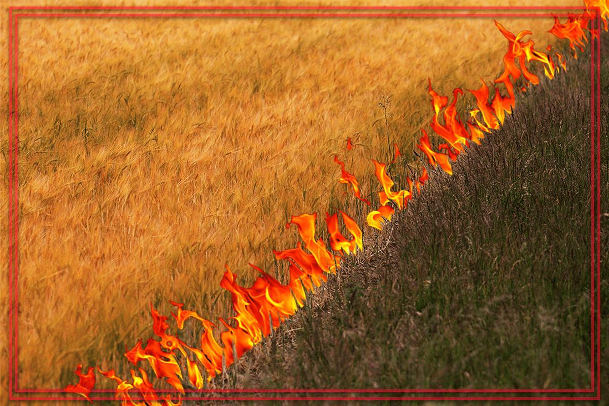
But grass fires are a growing danger in the United States, even if they lack the iconic imagery of the forest fires that tend to dominate the news this time of year. The 2018 Martin fire in Nevada, the largest in the state’s history, burned 435,000 acres of invasive cheatgrass and at one point stretched 54 miles long. The 2006 East Amarillo Complex fire in Texas blackened almost a million acres. And the wildfires in Maui this month were the deadliest in modern U.S. history, in part because they ignited in highly flammable non-native grasses, which burn hot, fast, and unpredictably.
“They’re too intense for firefighters to get next to with either ‘dozers or engines,” Brad Smith, the Predictive Services department head at Texas A&M Forest Service, told me of the wind-driven grass fires he sees across Texas. “They also move too fast, so it’s dangerous to put people out in front of these fires. It’s often the case we have to wait either for the weather to change or for the fire to move into a more favorable fuel type,” such as plowed agricultural land, before first responders can get it under control.
I had reached out to Smith after seeing him dispense grassland firefighting advice in a 2011 educational video for firefighters titled, “Oh, It’s Just a Grass Fire.” Produced by the Wildland Fire Lessons Learned Center — a grimly named government agency that exists to “share lessons and knowledge within the entire wildland fire community” — the video was apparently intended to head off dismissals of what it calls a “potentially underestimated fuel type.”
Such an underestimation in the industry comes from the fact that grass fires can actually have “a few advantages” for wildland firefighters, as authors Justin Angle and Nick Mott write in their forthcoming guide This Is Wildfire. “There are a lot of fire-fighting strategies that are just more feasible in a grassy landscape that’s more open and has more fuel breaks like roads and bodies of water,” the authors go on to explain. “In addition, the fuel type is more homogenous (and therefore predictable) compared with a mountain ecosystem.”
But throw in high winds, and all of a sudden grassland fires can become a completely different beast. “People think [wildfires] just move in one direction, but winds generally quarter,” Smith said. “So let’s say you have a north wind; you think, Well, [the fire] is going south. But if you get a 45-degree change in direction, that fire can move left or right for short periods of time very quickly. That can catch people by surprise.” In the instructional video, this point is made with the cautionary tale of Destry Horton, a father of two who was killed fighting a grass fire in Oklahoma in 2006.
But if even firefighters need the occasional somber refresher to take grass fires seriously, then many of the rest of us have likely barely registered them as a threat. “I think a lot of people look at a grass fire and feel like, ‘Well, I could just go stomp it out,’” Barb Satink Wolfson, the University of California’s Cooperative Extension fire advisor for Monterey, San Benito, Santa Clara, and Santa Cruz counties, told me.
Perhaps that’s partially because “forest fire” is often interchanged with “wildfire,” inadvertently evoking the conflagration out of Bambi: popping evergreen trees, flames reaching for the sky, adorable woodland animals running for cover. Reality looks a little different: Grassland pasture and range make up 60% of land use in the Mountain West and about 29% of land use in the Pacific Coast states, the most recent survey by the United States Department of Agriculture found (compared to 18% and 29% forest-use land, respectively).
Fire statistics seem to bear that out: In a study of burns in 11 western states between 1984 and 2020, only 35% were actually in forests, Denver’s 5280 magazine reports. In another cited study, local fire departments “responded to forest fires just 7% of the time, compared to 39% for grass fires.” Smith also told me that of the 30 largest fires in Texas since 2000, 28 had “occurred in our grass-dominant fuel-scape in West Texas.”
The tragic consequence of the public not taking grass fires seriously — or not knowing to take them seriously — is that many people who live in wildland-urban interface communities near or adjacent to natural, undeveloped lands might not have made the proper wildfire preparations or have an evacuation plan because the fire threat feels remote.
That can prove deadly. A quarter of Hawaii is covered in highly flammable non-native grasses and “virtually every community [in the state] is on a wildland-urban interface,” one fire manager recently told Wired. Yet the communities were unsuspecting and unprepared for the fire that swept through Lahaina and the surrounding landscape last week. Part of that is because fire is “not something that has been a part of ... society in Hawaii,” Satink Wolfson said, adding: “There isn’t a big history of people telling [residents]: ‘You need metal gutters, you need to make your home fire safe.’”
Though fire is not a historic part of the ecology of Hawaii, it is in North American grasslands, where Indigenous communities have practiced cultural burning for centuries upon centuries. But non-native grass species are likewise disrupting these natural cycles in the western United States, since invasive plants tend to grow thickly and contiguously, unlike native perennials that grow in more isolated clumps that help naturally break up fires. By one estimate, invasive grasses can more than triple a region’s susceptibility to wildfire.
Making matters worse, non-native grasses tend to quickly colonize and outcompete native plants after burns, in effect bridging fire further and further into landscapes where it doesn’t belong, such as deserts — or urban environments. “Those non-native herbaceous species are like the wick,” Max Moritz, a Cooperative Extension wildfire specialist and adjunct professor at U.C. Santa Barbara’s Bren School of Environmental Science & Management, told me. “They’re the place that fire can get a foothold on the landscape, even if the landscape wasn’t supposed to burn very often from a fire ecology perspective.”
Increasingly, attention in the West has focused on allowing “good fires” to run their course — grass fires included. “I would love to see CalFire use natural ignitions to reduce fire hazard and to improve ecosystem health,” Satink Wolfson said. “I’ve already seen so many fires put out this year that could have had a positive impact.” Moritz’s focus is on better land-use planning, including rehabilitating abandoned farmlands into working buffer zones. Both Satink Wolfson and Moritz floated strategic grazing as another possibility. But everyone agrees: Something needs to be done.
“Grasslands — there’s a lot of area there to manage if you are hoping to reduce the ignition potential,” Moritz said, then ominously warned: “It’s almost all ignitable.”
Read more about grass fires:
Log in
To continue reading, log in to your account.
Create a Free Account
To unlock more free articles, please create a free account.
On China’s rare earths, Bill Gates’ nuclear dream, and Texas renewables
Current conditions: Hurricane Melissa exploded in intensity over the warm Caribbean waters and has now strengthened into a major storm, potentially slamming into Cuba, the Dominican Republic, Haiti, and Jamaica as a Category 5 in the coming days • The Northeast is bracing for a potential nor’easter, which will be followed by a plunge in temperatures of as much as 15 degrees Fahrenheit lower than average • The northern Australian town of Julia Creek saw temperatures soar as high as 106 degrees.
Exxon Mobil filed a lawsuit against California late Friday on the grounds that two landmark new climate laws violate the oil giant’s free speech rights, The New York Times reported. The two laws would require thousands of large companies doing business in the state to calculate and report the greenhouse gas pollution created by the use of their products, so-called Scope 3 emissions. “The statutes compel Exxon Mobil to trumpet California’s preferred message even though Exxon Mobil believes the speech is misleading and misguided,” Exxon complained through its lawyers. California Governor Gavin Newsom’s office said the statutes “have already been upheld in court and we continue to have confidence in them.” He condemned the lawsuit, calling it “truly shocking that one of the biggest polluters on the planet would be opposed to transparency.”
China will delay introducing export controls on rare earths, an unnamed U.S. official told the Financial Times following two days of talks in Malaysia. For years, Beijing has been ratcheting up trade restrictions on the global supply of metals its industry dominates. But this month, China slapped the harshest controls yet on rare earths. In response, stocks in rare earth mining and refining companies soared. Despite what Heatmap’s Matthew Zeitlin called the “paradox of Trump’s critical mineral crusade” to mine even as he reduced demand from electric vehicle factories, “everybody wants to invest in critical minerals startups,” Heatmap’s Katie Brigham wrote. That — as frequent readers of this newsletter will recall — includes the federal government, which under the Trump administration has been taking equity stakes in major projects as part of deals for federal funding.
The Nuclear Regulatory Commission rewarded Bill Gates’ next-generation reactor company, TerraPower, with its final environment impact statement last week. The next step in the construction permit process is a final safety evaluation that the company expects to receive by the end of this year. If everything goes according to plan, TerraPower could end up winning the race to build the nation’s first commercial reactor to use a coolant other than water, and do so at a former coal-fired plant in the country’s top coal-producing state. “The Natrium plant in Wyoming, Kemmerer Unit 1, is now the first advanced reactor technology to successfully complete an environmental impact statement for the NRC, bringing us another step closer to delivering America’s next nuclear power plant,” said TerraPower president and CEO Chris Levesque.
A judge gave New York Governor Kathy Hochul’s administration until February 6 to issue rules for its long-delayed cap-and-invest program, the Albany Times-Union reported. The government was supposed to issue the guidelines that would launch the program as early as 2024, but continuously pushed back the release. “Early outlines of New York’s cap and invest program indicate that regulators were considering a relatively low price ceiling on pollution, making it easier for companies to buy their way out of compliance with the cap,” Heatmap’s Emily Pontecorvo wrote in January.
 
The Texas data center boom is being powered primarily with new wind, solar, and batteries, according to new analysis by the Energy Information Administration. Since 2021, electricity demand on the independent statewide grid operated by the Electric Reliability Council of Texas has soared. Over the past year, wind, solar, and batteries have been supplying that rising demand. Utility-scale solar generated 45 terawatt-hours of electricity in the first nine months of 2025. That’s 50% more than the same period in 2024 and nearly four times more than the same period in 2021. Wind generation, meanwhile, totaled 87 terawatt-hours for the first nine months of this year, up 4% from last year and 36% since 2021. “Together,” the analysis stated, “wind and solar generation met 36% of ERCOT’s electricity demand in the first nine months of 2025.”
The question isn’t whether the flames will come — it’s when, and what it will take to recover.
In the two decades following the turn of the millennium, wildfires came within three miles of an estimated 21.8 million Americans’ homes. That number — which has no doubt grown substantially in the five years since — represents about 6% of the nation’s population, including the survivors of some of the deadliest and most destructive fires in the country’s history. But it also includes millions of stories that never made headlines.
For every Paradise, California, and Lahaina, Hawaii, there were also dozens of uneventful evacuations, in which regular people attempted to navigate the confusing jargon of government notices and warnings. Others lost their homes in fires that were too insignificant to meet the thresholds for federal aid. And there are countless others who have decided, after too many close calls, to move somewhere else.
By any metric, costly, catastrophic, and increasingly urban wildfires are on the rise. Nearly a third of the U.S. population, however, lives in a county with a high or very high risk of wildfire, including over 60% of the counties in the West. But the shape of the recovery from those disasters in the weeks and months that follow is often that of a maze, featuring heart-rending decisions and forced hands. Understanding wildfire recovery is critical, though, for when the next disaster follows — which is why we’ve set out to explore the topic in depth.
The most immediate concerns for many in the weeks following a wildfire are financial. Homeowners are still required to pay the mortgage on homes that are nothing more than piles of ash — one study by the Federal Reserve Bank of Philadelphia found that 90-day delinquencies rose 4% and prepayments rose 16% on properties that were damaged by wildfires. Because properties destroyed in fires often receive insurance settlements that are lower than the cost to fully replace their home, “households face strong incentives to apply insurance funds toward the mortgage balance instead of rebuilding, and the observed increase in prepayment represents a symptom of broader frictions in insurance markets that leave households with large financial losses in the aftermath of a natural disaster,” the researchers explain.
Indeed, many people who believed they had adequate insurance only discover after a fire that their coverage limits are lower than 75% of their home’s actual replacement costs, putting them in the category of the underinsured. Homeowners still grappling with the loss of their residence and possessions are also left to navigate reams of required paperwork to get their money, a project one fire victim likened to having a “part-time job.” It’s not uncommon for fire survivors to wait months or even years for payouts, or to find that necessary steps to rebuilding, such as asbestos testing and dead tree removals, aren’t covered. Just last week, California Governor Gavin Newsom signed a new law requiring insurers to pay at least 60% of a homeowner’s personal property coverage on a total loss without a detailed inventory, up to $350,000. The original proposal called for a 100% payout, but faced intense insurance industry blowback .
Even if your home doesn’t burn to the ground, you might be affected by the aftermath of a nearby fire. In California, a fifth of homes in the highest-risk wildfire areas have lost insurance coverage since 2019, while premiums in those same regions have increased by 42%. Insurers’ jitters have overflowedspilled over into other Western states like Washington, where there are fewer at-risk properties than in California — 16% compared to 41% — but premiums have similarly doubled in some cases due to the perceived hazardrisks.
Some experts argue that people should be priced out of the wildland-urban interface and that managed retreat will help prevent future tragedies. But as I report in my story on fire victims who’ve decided not to rebuild, that’s easier said than done. There are only three states where insured homeowners have the legal right to replace a wildfire-destroyed home by buying a new property instead of rebuilding, meaning many survivors end up shackled to a property that is likely to burn again.
The financial maze, of course, is only one aspect of recovery — the physical and mental health repercussions can also reverberate for years. A study that followed survivors of Australia’s Black Saturday bush fires in 2009, which killed over 170 people, found that five years after the disaster, a fifth of survivors still suffered from “serious mental health challenges” like post-traumatic stress disorder. In Lahaina, two years after the fire, nearly half of the children aged 10 to 17 who survived are suspected of coping with PTSD.
Federal firefighting practices continue to focus on containing fires as quickly as possible, to the detriment of less showy but possibly more effective solutions such as prescribed burns and limits on development in fire-prone areas. Some of this is due to the long history of fire suppression in the West, but it persists due to ongoing political and public pressure. Still, you can find small and promising steps forward for forest management in places like Paradise, where the recreation and park district director has scraped together funds to begin to build a buffer between an ecosystem that is meant to burn and survivors of one of the worst fires in California’s history.
In the four pieces that follow, I’ve attempted to explore the challenges of wildfire recovery in the weeks and months after the disaster itself. In doing so, I’ve spoken to firefighters, victims, researchers, and many others to learn more about what can be done to make future recoveries easier and more effective.
The bottom line, though, is that there is no way to fully prevent wildfires. We have to learn to live alongside them, and that means recovering smarter, too. It’s not the kind of glamorous work that attracts TV cameras and headlines; often, the real work of recovery occurs in the many months after the fire is extinguished. But it also might just make the difference.
Wildfire evacuation notices are notoriously confusing, and the stakes are life or death. But how to make them better is far from obvious.
How many different ways are there to say “go”? In the emergency management world, it can seem at times like there are dozens.
Does a “level 2” alert during a wildfire, for example, mean it’s time to get out? How about a “level II” alert? Most people understand that an “evacuation order” means “you better leave now,” but how is an “evacuation warning” any different? And does a text warning that “these zones should EVACUATE NOW: SIS-5111, SIS-5108, SIS-5117…” even apply to you?
As someone who covers wildfires, I’ve been baffled not only by how difficult evacuation notices can be to parse, but also by the extent to which they vary in form and content across the United States. There is no centralized place to look up evacuation information, and even trying to follow how a single fire develops can require hopping among jargon-filled fire management websites, regional Facebook pages, and emergency department X accounts — with some anxious looking-out-the-window-at-the-approaching-pillar-of-smoke mixed in.
Google and Apple Maps don’t incorporate evacuation zone data. Third-party emergency alert programs have low subscriber rates, and official government-issued Wireless Emergency Alerts, or WEAs — messages that trigger a loud tone and vibration to all enabled phones in a specific geographic region — are often delayed, faulty, or contain bad information, none of which is ideal in a scenario where people are making life-or-death decisions. The difficulty in accessing reliable information during fast-moving disasters like wildfires is especially aggravating when you consider that nearly everyone in America owns a smartphone, i.e. a portal to all the information in the world.
So why is it still so hard to learn when and where specific evacuation notices are in place, or if they even apply to you? The answer comes down to the decentralized nature of emergency management in the United States.
A downed power line sparks a fire on a day with a Red Flag Warning. A family driving nearby notices the column of smoke and calls to report it to 911. The first responders on the scene realize that the winds are fanning the flames toward a neighborhood, and the sheriff decides to issue a wildfire warning, communicating to the residents that they should be ready to leave at a moment’s notice. She radios her office — which is now fielding multiple calls asking for information about the smoke column — and asks for the one person in the office that day with training on the alert system to compose the message.
Scenarios like these are all too common. “The people who are put in the position of issuing the messages are doing 20 other things at the same time,” Jeannette Sutton, a researcher at the University at Albany’s Emergency and Risk Communication Message Testing Lab, told me. “They might have limited training and may not have had the opportunity to think about what the messages might contain — and then they’re told by an incident commander, Send this, and they’re like, Oh my God, what do I do?”
The primary way of issuing wildfire alerts is through WEAs, with 78,000 messages sent since 2012. Although partnerships between local emergency management officials, the Federal Emergency Management Agency, the Federal Communications Commission, and cellular and internet providers facilitate the technology, it’s local departments that determine the actual content of the message. Messaging limits force some departments to condense the details of complicated and evolving fire events into 90 characters or fewer. Typos, confusing wording, and jargon inevitably abound.
Emergency management teams often prefer to err on the side of sending too few messages rather than too many for fear of inducing information overload. “We’re so attached to our devices, whether it’s Instagram or Facebook or text messages, that it’s hard to separate the wheat from the chaff, so to speak — to make sure that we are getting the right information out there,” John Rabin, the vice president of disaster management at the consulting firm ICF International and a former assistant administrator at the Federal Emergency Management Agency, told me. “One of the challenges for local and state governments is how to bring [pertinent information] up and out, so that when they send those really important notifications for evacuations, they really resonate.”
But while writing an emergency alert is a bit of an art, active prose alone doesn’t ensure an effective evacuation message.
California’s Cal Fire has found success with the “Ready, Set, Go” program, designed by the International Association of Fire Chiefs, which uses an intuitive traffic light framework — “ready” is the prep work of putting together a go-bag and waiting for more news if a fire is in the vicinity, escalating to the “go” of the actual evacuation order. Parts of Washington and Oregon use similar three-tiered systems of evacuation “levels” ranging from 1 to 3. Other places, like Montana, rely on two-step “evacuation warnings” and “evacuation orders.”
Watch Duty, a website and app that surged in popularity during the Los Angeles fires earlier this year, doesn’t worry about oversharing. Most information on Watch Duty comes from volunteers, who monitor radio scanners, check wildfire cameras, and review official law enforcement announcements, then funnel the information to the organization’s small staff, who vet it before posting. Though WatchDuty volunteers and staff — many of whom are former emergency managers or fire personnel themselves — actively review and curate the information on the app, the organization still publishes far more frequent and iterative updates than most people are used to seeing and interpreting. As a result, some users and emergency managers have criticized Watch Duty for having too much information available, as a result.
The fact that Watch Duty was downloaded more than 2 million times during the L.A. fires, though, would seem to testify to the fact that people really are hungry for information in one easy-to-locate place. The app is now available in 22 states, with more than 250 volunteers working around the clock to keep wildfire information on the app up to date. John Clarke Mills, the app’s CEO and co-founder, has said he created the app out of “spite” over the fact that the government doesn’t have a better system in place for keeping people informed on wildfires.
“I’ve not known too many situations where not having information makes it better,” Katlyn Cummings, the community manager at Watch Duty, told me. But while the app’s philosophy is “rooted in transparency and trust with our users,” Cummings stressed to me that the app’s volunteers only use official and public sources of information for their updates and never include hearsay, separating it from other crowd-sourced community apps that have proved to be less than reliable.
Still, it takes an army of a dozen full-time staff and over 200 part-time volunteers, plus an obsessively orchestrated Slack channel to centralize the wildfire and evacuation updates — which might suggest why a more official version doesn’t exist yet, either from the government or a major tech company. Google Maps currently uses AI to visualize the boundaries of wildfires, but stops short of showing users the borders of local evacuation zones (though it will route you around known road closures). A spokesperson for Google also pointed me toward a feature in Maps that shares news articles, information from local authorities, and emergency numbers when users are in “the immediate vicinity” of an actively unfolding natural disaster — a kind of do-it-yourself Watch Duty. The company declined to comment on the record about why Maps specifically excludes evacuation zones. Apple did not respond to a request for comment.
There is, of course, a major caveat to the usefulness of Watch Duty.
Users of the app tend to be a self-selecting group of hyper-plugged-in digital natives who are savvy enough to download it or otherwise know to visit the website during an unfolding emergency. As Rabin, the former FEMA official, pointed out, Watch Duty users aren’t the population that first responders are most concerned about — they’re like “Boy Scouts,” he said, because they’re “always prepared.” They’re the ones who already know what’s going on. “It’s reaching the folks that aren’t paying attention that is the big challenge,” he told me.
The older adult population is the most vulnerable in cases of wildfire. Death tolls often skew disproportionately toward the elderly; of the 30 people who died in the Los Angeles fires in January, for example, all but two were over 60 or disabled, with the average age of the deceased 77, the San Francisco Chronicle reported. Part of that is because adults 65 and older are more likely to have physical impairments that make quick or unplanned evacuations challenging. Social and technological isolation are also factors — yes, almost everyone in America has a smartphone, but that includes just 80% of those 65 and older, and only 26% of the older adult population feels “very confident” using computers or smartphones. According to an extensive 2024 report on how extreme weather impacts older adults by CNA, an independent, nonprofit research organization, “Evacuation information, including orders, is not uniformly communicated in ways and via media that are accessible to older adults or those with access and functional needs.”
Sutton, the emergency warning researcher, also cautioned that more information isn’t always better. Similar to the way scary medical test results might appear in a health portal before a doctor has a chance to review them with you (and calm you down), wildfire information shared without context or interpretation from emergency management officials means the public is “making assumptions based upon what they see on Watch Duty without actually having those official messages coming from the public officials who are responsible for issuing those messages,” she said. One role of emergency managers is to translate the raw, on-the-ground information into actionable guidance. Absent that filter, panic is probable, which could lead to uncontrollable evacuation traffic or exacerbate alert fatigue. Alternatively, people might choose to opt out of future alerts or stop checking for updates.
Sutton, though she’s a strong advocate of creating standardized language for emergency alerts — “It would be wonderful if we had consistent language that was agreed upon” between departments, she told me — was ultimately skeptical of centralizing the emergency alert system under a large agency like FEMA. “The movement of wildfires is so fast, and it requires knowledge of the local communities and the local terrain as well as meteorological knowledge,” she said. “Alerts and warnings really should be local.”
The greater emphasis, Sutton stressed, should be on providing emergency managers with the training they need to communicate quickly, concisely, and effectively with the tools they already have.
The high wire act of emergency communications, though, is that while clear and regionally informed messages are critical during life-or-death situations, it also falls on residents in fire-risk areas to be ready to receive them. California first adopted the “Ready, Set, Go” framework in 2009, and it has spent an undisclosed amount of money over the years on a sustained messaging blitz to the public. (Cal Fire’s “land use planning and public education budget is estimated at $16 million, and funds things like the updated ad spots it released as recently as this August.) Still, there is evidence that even that has not been enough — and Cal Fire is the best-resourced firefighting agency in the country, setting the gold standard for an evacuation messaging campaign.
Drills and test messages are one way to bring residents up to speed, but participation is typically very low. Many communities and residents living in wildfire-risk areas continue to treat the threat with low urgency — something to get around to one day. But whether they’re coming from your local emergency management department or the White House itself, emergency notices are only as effective as the public is willing and able to heed them.